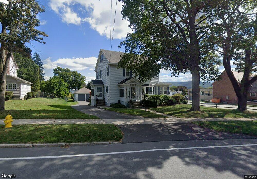
156 Benedict Rd Pittsfield, MA 01201
Estimated Value: $292,000 - $338,000
3
Beds
2
Baths
1,824
Sq Ft
$170/Sq Ft
Est. Value
About This Home
This home is located at 156 Benedict Rd, Pittsfield, MA 01201 and is currently estimated at $309,301, approximately $169 per square foot. 156 Benedict Rd is a home located in Berkshire County with nearby schools including Allendale Elementary School, Theodore Herberg Middle School, and Pittsfield High School.
Ownership History
Date
Name
Owned For
Owner Type
Purchase Details
Closed on
Aug 22, 2023
Sold by
Powers Anne S
Bought by
Powers Anne S and Powers John J
Current Estimated Value
Purchase Details
Closed on
Jun 26, 2023
Sold by
Powers Richard A Est and Powers
Bought by
Richard A Powers T A and Richard Powers
Purchase Details
Closed on
May 4, 2021
Sold by
Powers Richard A and Powers Anne S
Bought by
Powers Richard A and Powers Anne S
Purchase Details
Closed on
Apr 15, 1969
Bought by
Powers Richard A and Powers Anne S
Create a Home Valuation Report for This Property
The Home Valuation Report is an in-depth analysis detailing your home's value as well as a comparison with similar homes in the area
Home Values in the Area
Average Home Value in this Area
Purchase History
| Date | Buyer | Sale Price | Title Company |
|---|---|---|---|
| Powers Anne S | -- | None Available | |
| Powers Anne S | -- | None Available | |
| Powers Anne S | -- | None Available | |
| Richard A Powers T A | -- | None Available | |
| Richard A Powers T A | -- | None Available | |
| Richard A Powers T A | -- | None Available | |
| Powers Richard A | -- | None Available | |
| Powers Richard A | -- | None Available | |
| Powers Richard A | -- | None Available | |
| Powers Richard A | -- | -- |
Source: Public Records
Tax History
| Year | Tax Paid | Tax Assessment Tax Assessment Total Assessment is a certain percentage of the fair market value that is determined by local assessors to be the total taxable value of land and additions on the property. | Land | Improvement |
|---|---|---|---|---|
| 2025 | $4,831 | $269,300 | $67,500 | $201,800 |
| 2024 | $4,434 | $240,300 | $67,500 | $172,800 |
| 2023 | $4,085 | $223,000 | $62,500 | $160,500 |
| 2022 | $3,695 | $199,100 | $60,000 | $139,100 |
| 2021 | $3,219 | $167,200 | $60,000 | $107,200 |
| 2020 | $3,223 | $163,500 | $60,000 | $103,500 |
| 2019 | $2,942 | $151,500 | $54,500 | $97,000 |
| 2018 | $2,961 | $148,000 | $54,500 | $93,500 |
| 2017 | $2,803 | $142,800 | $52,500 | $90,300 |
| 2016 | $2,662 | $141,900 | $52,500 | $89,400 |
| 2015 | $2,563 | $141,900 | $52,500 | $89,400 |
Source: Public Records
Map
Nearby Homes
- 21 Ensign Ave
- 81 Dartmouth St Unit 108
- 91 Dalton Ave
- 0 Stanley Ave
- 89 Delancy Ave
- 40 Roland St
- 74 Norman Ave
- 162 Woodlawn Ave
- 258 Dalton Ave
- 71 Dickinson Ave
- 121 Elberon Ave
- I11001904 Scammell Ave
- 0 Parker St
- 135 Allengate Ave
- 0 Brown St
- 48 Brown St
- 56 Spring St
- 0 Courtland Place
- 762 East St
- 10 Huron St
- 158 Benedict Rd
- 133 Dalton Ave
- 141 Dalton Ave
- 162 Benedict Rd
- 147 Dalton Ave
- 159 Benedict Rd
- 17 Pittsfield Ave
- 168 Benedict Rd
- 23 Pittsfield Ave
- 155 Dalton Ave
- 157 Benedict Rd
- 21 Pittsfield Ave
- 161 Benedict Rd
- 31 Pittsfield Ave
- 163 Benedict Rd
- 174 Benedict Rd
- 159 Dalton Ave
- 35 Pittsfield Ave
- 140 Dalton Ave
- 154 Dalton Ave
Your Personal Tour Guide
Ask me questions while you tour the home.