
Seller's Agent in 2025
Laurie Norton Team
BHG Masiello Bedford
(603) 361-4804
9 in this area
489 Total Sales
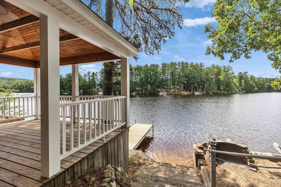
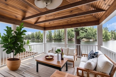
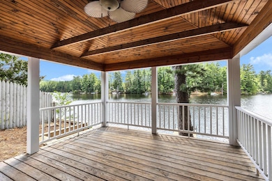
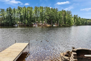
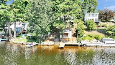
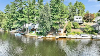

*OFFER DEADLINE WEDNESDAY 9/3 AT 3PM.* Love where you live in this 3-bedroom lakefront home! Located on Goffstown's Glen Lake, this home has a 2 car detached garage, an on-demand whole house generator, central air, and a fire pit alongside the lake's only gazebo. Launch your boat or jet ski down the road and tie up at your private dock for the season. Load the kayaks onto the built-in rack, and fill the fridge with drinks because you'll be spending all your time outside! This house has been transformed over the past four months. Fresh paint throughout...(walls, ceilings, trim and doors), new flooring, a new deck and so much more! This is one you need to see to believe. Primary bedroom and full bath on the 1st floor with views of the lake from the moment you wake up. This is a home for anyone who loves the outdoors. Views galore, summer fun and winter activities right out the front door. Assisted showings. OPEN HOUSES scheduled for the following: Friday 8/29 from 4:30-6:30pm, Saturday 8/30 from 11-1pm, Sunday 8/31 from 12-2pm and even Monday from 2-4pm. See you there!
Last Agent to Sell the Property
BHG Masiello Bedford License #058926 Listed on: 08/28/2025
| Date | Type | Sale Price | Title Company |
|---|---|---|---|
| Deed | $278,000 | -- | |
| Deed | $290,000 | -- | |
| Warranty Deed | $112,000 | -- | |
| Foreclosure Deed | $3,000 | -- | |
| Warranty Deed | $70,000 | -- |
| Date | Status | Loan Amount | Loan Type |
|---|---|---|---|
| Open | $250,200 | Purchase Money Mortgage | |
| Previous Owner | $245,000 | Unknown | |
| Previous Owner | $20,576 | Unknown |
| Date | Event | Price | List to Sale | Price per Sq Ft |
|---|---|---|---|---|
| 09/30/2025 09/30/25 | Sold | $680,000 | +8.8% | $424 / Sq Ft |
| 09/03/2025 09/03/25 | Pending | -- | -- | -- |
| 08/28/2025 08/28/25 | For Sale | $625,000 | -- | $390 / Sq Ft |
| Year | Tax Paid | Tax Assessment Tax Assessment Total Assessment is a certain percentage of the fair market value that is determined by local assessors to be the total taxable value of land and additions on the property. | Land | Improvement |
|---|---|---|---|---|
| 2024 | $11,244 | $550,100 | $322,100 | $228,000 |
| 2023 | $10,375 | $550,100 | $322,100 | $228,000 |
| 2022 | $9,451 | $359,200 | $205,700 | $153,500 |
| 2021 | $8,915 | $359,200 | $205,700 | $153,500 |
| 2020 | $8,915 | $359,200 | $205,700 | $153,500 |
| 2019 | $8,829 | $359,200 | $205,700 | $153,500 |
| 2018 | $6,681 | $359,200 | $205,700 | $153,500 |
| 2017 | $8,256 | $301,100 | $169,200 | $131,900 |
| 2016 | $7,958 | $301,100 | $169,200 | $131,900 |
| 2015 | $7,699 | $273,400 | $150,000 | $123,400 |
| 2014 | $7,190 | $266,300 | $150,000 | $116,300 |
Seller's Agent in 2025
Laurie Norton Team
BHG Masiello Bedford
(603) 361-4804
9 in this area
489 Total Sales
Source: PrimeMLS
MLS Number: 5058765
APN: GOFF-000036-000089
Disclaimer: Certain information contained herein is derived from information provided by parties other than Homes.com. All information provided is deemed reliable, but is not guaranteed to be accurate and should be independently verified.
![]() Copyright 2025 PrimeMLS, Inc. All rights reserved. This information is deemed reliable, but not guaranteed. The data relating to real estate displayed on this display comes in part from the IDX Program of PrimeMLS. The information being provided is for consumers’ personal, non-commercial use and may not be used for any purpose other than to identify prospective properties consumers may be interested in purchasing.
Copyright 2025 PrimeMLS, Inc. All rights reserved. This information is deemed reliable, but not guaranteed. The data relating to real estate displayed on this display comes in part from the IDX Program of PrimeMLS. The information being provided is for consumers’ personal, non-commercial use and may not be used for any purpose other than to identify prospective properties consumers may be interested in purchasing.