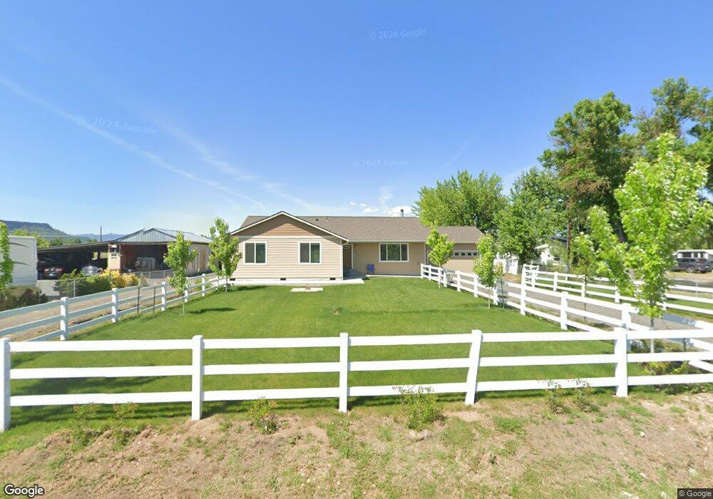
1562 Newland Rd Central Point, OR 97502
Estimated Value: $533,000 - $831,000
3
Beds
2
Baths
1,680
Sq Ft
$377/Sq Ft
Est. Value
About This Home
This home is located at 1562 Newland Rd, Central Point, OR 97502 and is currently estimated at $633,251, approximately $376 per square foot. 1562 Newland Rd is a home located in Jackson County with nearby schools including Jewett Elementary School, Scenic Middle School, and Crater High School.
Ownership History
Date
Name
Owned For
Owner Type
Purchase Details
Closed on
Aug 12, 1999
Sold by
Poythress Bonnie L
Bought by
Granger Randy
Current Estimated Value
Home Financials for this Owner
Home Financials are based on the most recent Mortgage that was taken out on this home.
Original Mortgage
$90,850
Outstanding Balance
$26,209
Interest Rate
7.7%
Mortgage Type
Purchase Money Mortgage
Estimated Equity
$607,042
Create a Home Valuation Report for This Property
The Home Valuation Report is an in-depth analysis detailing your home's value as well as a comparison with similar homes in the area
Home Values in the Area
Average Home Value in this Area
Purchase History
| Date | Buyer | Sale Price | Title Company |
|---|---|---|---|
| Granger Randy | $93,700 | -- |
Source: Public Records
Mortgage History
| Date | Status | Borrower | Loan Amount |
|---|---|---|---|
| Open | Granger Randy | $90,850 |
Source: Public Records
Tax History Compared to Growth
Tax History
| Year | Tax Paid | Tax Assessment Tax Assessment Total Assessment is a certain percentage of the fair market value that is determined by local assessors to be the total taxable value of land and additions on the property. | Land | Improvement |
|---|---|---|---|---|
| 2025 | $3,324 | $277,250 | $69,470 | $207,780 |
| 2024 | $3,324 | $269,180 | $94,630 | $174,550 |
| 2023 | $3,213 | $261,340 | $91,870 | $169,470 |
| 2022 | $3,145 | $253,730 | $89,200 | $164,530 |
| 2021 | $1,218 | $101,170 | $89,200 | $11,970 |
| 2020 | $1,416 | $98,230 | $86,610 | $11,620 |
| 2019 | $1,383 | $110,820 | $49,490 | $61,330 |
| 2018 | $1,340 | $107,600 | $48,060 | $59,540 |
| 2017 | $1,309 | $107,600 | $48,060 | $59,540 |
| 2016 | $1,271 | $101,430 | $45,300 | $56,130 |
| 2015 | $1,224 | $101,430 | $45,300 | $56,130 |
| 2014 | $1,177 | $95,620 | $42,710 | $52,910 |
Source: Public Records
Map
Nearby Homes
- 6850 Downing Rd Unit 44
- 6850 Downing Rd Unit 65
- 644 Raven
- 6199 Wilson Ln
- 225 Wilson Rd
- 2035 Rabun Way
- 4035 Rock Way
- 6251 Ventura Ln
- 335 Applewood Dr
- 1409 Twin Rocks Dr
- 2248 Evan Way
- 2330 Savannah Dr
- 2598 St James Way
- 4922 Gebhard Rd
- 2225 New Haven Dr
- 356 Marian Ave Unit 40
- 0 Peninger Rd
- 413 Sand Pointe Dr
- 1729 E Gregory Rd
- 920 N 10th St
- 1560 Newland Rd
- 1648 Newland Rd
- 1564 Newland Rd
- 7344 Table Rock Terrace
- 7352 Table Rock Terrace
- 7293 Table Rock Terrace
- 7388 Table Rock Terrace
- 1780 Newland Rd
- 0 Table Rock Terrace
- 0 Table Rock Terrace
- 7570 Truax Rd
- 1792 Newland Rd
- 7414 Truax Rd
- 7452 Truax Rd
- 7598 Truax Rd
- 7465 Table Rock Terrace
- 7516 Truax Rd
- 7464 Table Rock Terrace
- 7542 Truax Rd
- 7556 Truax Rd