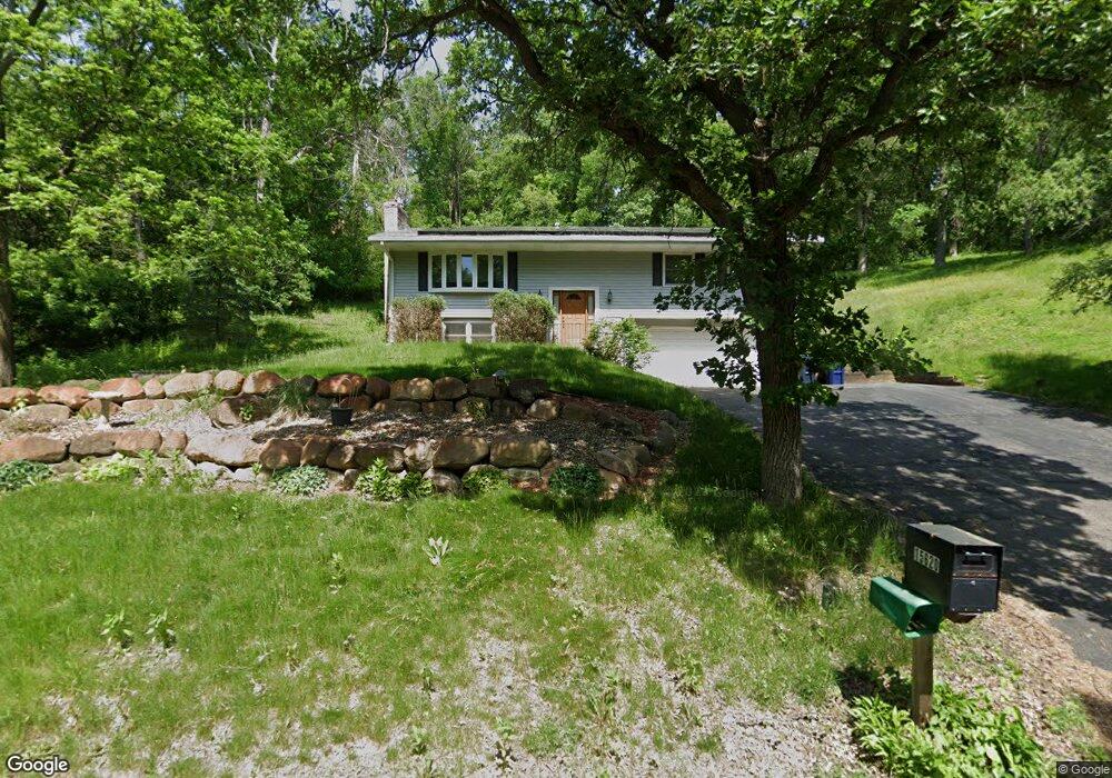
15620 Crest Dr Burnsville, MN 55306
Estimated Value: $394,000 - $408,000
3
Beds
3
Baths
1,927
Sq Ft
$208/Sq Ft
Est. Value
About This Home
This home is located at 15620 Crest Dr, Burnsville, MN 55306 and is currently estimated at $401,298, approximately $208 per square foot. 15620 Crest Dr is a home located in Dakota County with nearby schools including Impact Academy at Orchard Lake Elementary School, Kenwood Trail Middle School, and Lakeville South High School.
Ownership History
Date
Name
Owned For
Owner Type
Purchase Details
Closed on
Dec 30, 2019
Sold by
Peters Gordon E and Peters Muriel M
Bought by
Blair Brandon Leo and Blair Abby Elisabeth
Current Estimated Value
Home Financials for this Owner
Home Financials are based on the most recent Mortgage that was taken out on this home.
Original Mortgage
$275,500
Outstanding Balance
$243,884
Interest Rate
3.7%
Mortgage Type
New Conventional
Estimated Equity
$157,414
Create a Home Valuation Report for This Property
The Home Valuation Report is an in-depth analysis detailing your home's value as well as a comparison with similar homes in the area
Home Values in the Area
Average Home Value in this Area
Purchase History
| Date | Buyer | Sale Price | Title Company |
|---|---|---|---|
| Blair Brandon Leo | $290,000 | Titlesmart Inc |
Source: Public Records
Mortgage History
| Date | Status | Borrower | Loan Amount |
|---|---|---|---|
| Open | Blair Brandon Leo | $275,500 |
Source: Public Records
Tax History Compared to Growth
Tax History
| Year | Tax Paid | Tax Assessment Tax Assessment Total Assessment is a certain percentage of the fair market value that is determined by local assessors to be the total taxable value of land and additions on the property. | Land | Improvement |
|---|---|---|---|---|
| 2024 | $3,576 | $330,700 | $118,900 | $211,800 |
| 2023 | $3,576 | $300,400 | $108,400 | $192,000 |
| 2022 | $3,422 | $307,800 | $108,200 | $199,600 |
| 2021 | $3,486 | $277,300 | $94,100 | $183,200 |
| 2020 | $3,132 | $276,900 | $89,600 | $187,300 |
| 2019 | $2,939 | $266,200 | $85,300 | $180,900 |
| 2018 | $2,587 | $259,100 | $77,500 | $181,600 |
| 2017 | $2,377 | $232,500 | $77,400 | $155,100 |
| 2016 | $2,506 | $214,100 | $70,300 | $143,800 |
| 2015 | $2,091 | $198,309 | $62,677 | $135,632 |
| 2014 | -- | $177,490 | $60,365 | $117,125 |
| 2013 | -- | $157,652 | $54,138 | $103,514 |
Source: Public Records
Map
Nearby Homes
- 1312 Fremont Ct
- XXXX Judicial Rd
- 15455 Fremont Ave S
- 1005 Hilloway Cir
- 2204 Wildwood Ct
- 2300 Wildwood Ct
- 155xx Loop Rd S
- 15203 Greenhaven Way
- 15012 Willa Ct
- 15017 Orchard Dr
- 14920 Sharon Ln
- 16720 Klamath Tl
- 344 Stonewood Place
- 900 Windemere Way
- 594 Stonewood Ln
- 16720 Klamath Trail
- 14900 Viewcrest Ln
- 14908 Judicial Rd
- 1212 Hillside Ln
- 600 Greenhaven Dr Unit 213
- 15700 Crest Dr
- 15515 Kings Ct
- 15509 Kings Ct
- 15600 Crest Dr
- 1900 Sumac Ln
- 15508 Kings Ct
- 15516 Crest Dr
- 15615 James Ave S
- 15701 James Ave S
- 15505 Kings Ct
- 15720 Crest Dr
- 15624 County Road 5
- 1908 Sumac Ln
- 15517 Crest Dr
- 15514 Crest Dr
- 15504 Kings Ct
- 2000 Sumac Ln
- 1605 W 156th St
- 1608 W 156th St
- 15515 Crest Dr