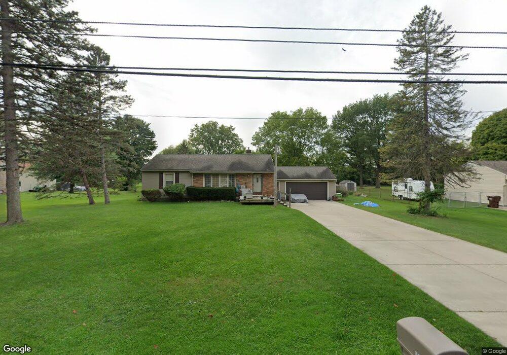
15632 Brook Rd Lansing, MI 48906
Estimated Value: $198,311 - $217,000
2
Beds
1
Bath
1,016
Sq Ft
$208/Sq Ft
Est. Value
About This Home
This home is located at 15632 Brook Rd, Lansing, MI 48906 and is currently estimated at $211,578, approximately $208 per square foot. 15632 Brook Rd is a home located in Clinton County with nearby schools including Gier Park School, Pattengill Academy, and Eastern High School.
Ownership History
Date
Name
Owned For
Owner Type
Purchase Details
Closed on
Jul 28, 2025
Sold by
Crow Michael
Bought by
Crow Sylvia
Current Estimated Value
Purchase Details
Closed on
Jun 2, 2003
Sold by
Jones Leary E and Jones Florence W
Bought by
Crow Michael and Christmas Sylvia
Home Financials for this Owner
Home Financials are based on the most recent Mortgage that was taken out on this home.
Original Mortgage
$125,100
Interest Rate
5.71%
Mortgage Type
Purchase Money Mortgage
Create a Home Valuation Report for This Property
The Home Valuation Report is an in-depth analysis detailing your home's value as well as a comparison with similar homes in the area
Home Values in the Area
Average Home Value in this Area
Purchase History
| Date | Buyer | Sale Price | Title Company |
|---|---|---|---|
| Crow Sylvia | -- | None Listed On Document | |
| Crow Michael | $129,000 | Transnation Title |
Source: Public Records
Mortgage History
| Date | Status | Borrower | Loan Amount |
|---|---|---|---|
| Previous Owner | Crow Michael | $125,100 |
Source: Public Records
Tax History
| Year | Tax Paid | Tax Assessment Tax Assessment Total Assessment is a certain percentage of the fair market value that is determined by local assessors to be the total taxable value of land and additions on the property. | Land | Improvement |
|---|---|---|---|---|
| 2025 | $2,527 | $96,800 | $21,700 | $75,100 |
| 2024 | $13 | $90,300 | $20,300 | $70,000 |
| 2023 | $1,274 | $84,800 | $0 | $0 |
| 2022 | $2,301 | $75,700 | $18,000 | $57,700 |
| 2021 | $2,236 | $71,700 | $17,400 | $54,300 |
| 2020 | $2,197 | $68,800 | $16,400 | $52,400 |
| 2019 | $2,497 | $65,300 | $15,400 | $49,900 |
| 2018 | $2,181 | $56,100 | $17,100 | $39,000 |
| 2017 | $2,161 | $52,900 | $15,600 | $37,300 |
| 2016 | $1,962 | $48,900 | $14,700 | $34,200 |
| 2015 | $1,825 | $45,700 | $0 | $0 |
| 2011 | -- | $53,300 | $0 | $0 |
Source: Public Records
Map
Nearby Homes
- 15710 Oak Lane Dr
- 15860 Brook Rd
- 1015 Pearl St
- 15378 Chetwyn Dr
- 15897 Elmira St
- E State Rd
- 1230 W Wieland Rd
- 1401 Bennett Rd
- 16550 S Us 27
- 605 Galahad Dr Unit 374
- 1901 E Stoll Rd
- 107 Normandy Dr Unit 100
- 108 Normandy Dr Unit 77
- 606 Eastgate Dr Unit 384
- 61 Beejay Dr
- 152 Donald Ave Unit 152
- 27 Beejay Dr Unit 27
- 93 Nettie Ave Unit 93
- 92 Nettie Ave Unit 92
- 86 Nettie Ave Unit 86
- 15630 Brook Rd
- 15660 Brook Rd
- 15600 Brook Rd
- 15631 Brook Rd
- 15661 Brook Rd
- 15686 Brook Rd
- 15601 Brook Rd
- 15685 Brook Rd
- 15550 Brook Rd
- 15712 Brook Rd
- 15630 Oak Lane Dr
- 15573 Brook Rd
- 15660 Oak Lane Dr
- 15711 Brook Rd
- 1010 Boichot Rd
- 1201 Oak Lane Dr
- 15684 Oak Lane Dr
- 1016 Boichot Rd
- 15734 Brook Rd
- Lot 23 S Us 27 Vacant Land
Your Personal Tour Guide
Ask me questions while you tour the home.