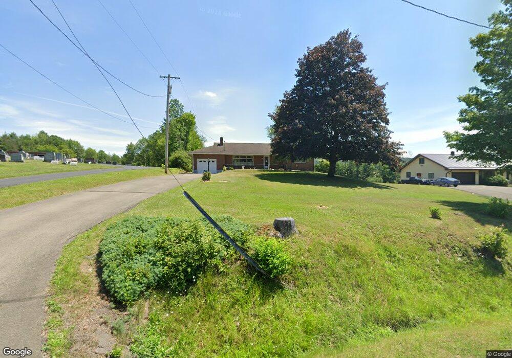
1566 Airport Rd Binghamton, NY 13905
Estimated Value: $85,000 - $200,000
3
Beds
2
Baths
1,716
Sq Ft
$93/Sq Ft
Est. Value
About This Home
This home is located at 1566 Airport Rd, Binghamton, NY 13905 and is currently estimated at $160,178, approximately $93 per square foot. 1566 Airport Rd is a home with nearby schools including Johnson City Primary School, Johnson City Intermediate School, and Johnson City Middle School.
Ownership History
Date
Name
Owned For
Owner Type
Purchase Details
Closed on
May 29, 2020
Sold by
Zlock Curtis J
Bought by
Zlock Conrad R
Current Estimated Value
Home Financials for this Owner
Home Financials are based on the most recent Mortgage that was taken out on this home.
Original Mortgage
$53,000
Interest Rate
2.9%
Mortgage Type
New Conventional
Purchase Details
Closed on
May 11, 2012
Sold by
Skok Louise E and Zlock Conrad R
Bought by
Zlock Conrad R and Zlock Curtis J
Purchase Details
Closed on
Apr 17, 2009
Sold by
Skok
Bought by
Zlock Conrad
Create a Home Valuation Report for This Property
The Home Valuation Report is an in-depth analysis detailing your home's value as well as a comparison with similar homes in the area
Home Values in the Area
Average Home Value in this Area
Purchase History
| Date | Buyer | Sale Price | Title Company |
|---|---|---|---|
| Zlock Conrad R | $45,000 | None Available | |
| Zlock Conrad R | -- | None Available | |
| Zlock Conrad | -- | John Cenesky |
Source: Public Records
Mortgage History
| Date | Status | Borrower | Loan Amount |
|---|---|---|---|
| Previous Owner | Zlock Conrad R | $53,000 |
Source: Public Records
Tax History Compared to Growth
Tax History
| Year | Tax Paid | Tax Assessment Tax Assessment Total Assessment is a certain percentage of the fair market value that is determined by local assessors to be the total taxable value of land and additions on the property. | Land | Improvement |
|---|---|---|---|---|
| 2024 | $3,416 | $3,600 | $150 | $3,450 |
| 2023 | $3,758 | $3,600 | $150 | $3,450 |
| 2022 | $3,786 | $3,600 | $150 | $3,450 |
| 2021 | $3,744 | $3,600 | $150 | $3,450 |
| 2020 | $3,401 | $3,600 | $150 | $3,450 |
| 2019 | $0 | $3,600 | $150 | $3,450 |
| 2018 | $1,744 | $3,600 | $150 | $3,450 |
| 2017 | $1,639 | $3,600 | $150 | $3,450 |
| 2016 | $1,622 | $3,600 | $150 | $3,450 |
| 2015 | -- | $3,600 | $150 | $3,450 |
| 2014 | -- | $3,600 | $150 | $3,450 |
Source: Public Records
Map
Nearby Homes
- 33 E Maine Rd
- 926 & 928 Upper Front St
- 1124 Tamara Ln
- 16 Penna Rd
- 1151 Reynolds Rd
- 8 Eric Dr
- 18 Eric Dr
- 1111 Anna Maria Dr
- 1107 Anna Maria Dr
- 156 Deyo Hill Rd
- 904 Dellapenna Dr
- 136 W Chenango Rd
- 268 Ransom Rd
- 513 Columbia Dr
- 270 Glenwood Rd
- 10 Poland Ave
- 66 Leigh St
- 289 Lower Stella Ireland Rd
- 287 Lower Stella Ireland Rd
- 57 Miriam St
- 1556 Airport Rd
- 1546 Airport Rd
- 1608 Airport Rd
- 1612 Airport Rd
- 1616 Airport Rd
- 1611 Airport Rd
- 1617 Airport Rd
- 173 Dimmock Hill Rd
- 175 Dimmock Hill Rd
- 1621 Airport Rd
- 179 Dimmock Hill Rd
- 1629 Airport Rd
- 170 Dimmock Hill Rd
- 1498 Airport Rd
- 182 Dimmock Hill Rd
- 1628 Airport Rd
- 219 Dimmock Hill Rd
- 194 Aitchison Rd
- 1601 Airport Rd
- 90 Dimmock Hill Rd