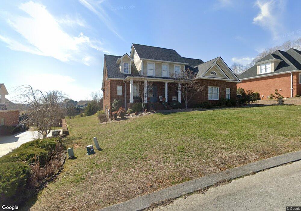
157 Golf Ridge Dr Kingsport, TN 37664
Estimated Value: $747,000 - $856,000
5
Beds
4
Baths
5,100
Sq Ft
$157/Sq Ft
Est. Value
About This Home
This home is located at 157 Golf Ridge Dr, Kingsport, TN 37664 and is currently estimated at $800,567, approximately $156 per square foot. 157 Golf Ridge Dr is a home located in Sullivan County with nearby schools including Thomas Jefferson Elementary School, Ross N. Robinson Middle School, and Dobyns-Bennett High School.
Ownership History
Date
Name
Owned For
Owner Type
Purchase Details
Closed on
May 27, 2011
Current Estimated Value
Home Financials for this Owner
Home Financials are based on the most recent Mortgage that was taken out on this home.
Original Mortgage
$397,912
Outstanding Balance
$262,714
Interest Rate
3.75%
Mortgage Type
VA
Estimated Equity
$537,853
Purchase Details
Closed on
Oct 18, 2004
Purchase Details
Closed on
Aug 25, 2003
Purchase Details
Closed on
Dec 23, 2002
Create a Home Valuation Report for This Property
The Home Valuation Report is an in-depth analysis detailing your home's value as well as a comparison with similar homes in the area
Home Values in the Area
Average Home Value in this Area
Purchase History
| Date | Buyer | Sale Price | Title Company |
|---|---|---|---|
| -- | $459,300 | -- | |
| Farmer Gregory P | $459,250 | -- | |
| -- | $30,000 | -- | |
| -- | $225,000 | -- | |
| -- | $205,000 | -- |
Source: Public Records
Mortgage History
| Date | Status | Borrower | Loan Amount |
|---|---|---|---|
| Open | Farmer Gregory P | $397,912 | |
| Closed | -- | $397,912 |
Source: Public Records
Tax History Compared to Growth
Tax History
| Year | Tax Paid | Tax Assessment Tax Assessment Total Assessment is a certain percentage of the fair market value that is determined by local assessors to be the total taxable value of land and additions on the property. | Land | Improvement |
|---|---|---|---|---|
| 2024 | -- | $128,150 | $17,500 | $110,650 |
| 2023 | $5,645 | $128,150 | $17,500 | $110,650 |
| 2022 | $5,645 | $128,150 | $17,500 | $110,650 |
| 2021 | $5,490 | $128,150 | $17,500 | $110,650 |
| 2020 | $3,031 | $128,150 | $17,500 | $110,650 |
| 2019 | $5,466 | $117,950 | $16,800 | $101,150 |
| 2018 | $5,338 | $117,950 | $16,800 | $101,150 |
| 2017 | $5,338 | $117,950 | $16,800 | $101,150 |
| 2016 | $5,565 | $119,800 | $16,800 | $103,000 |
| 2014 | $5,241 | $119,790 | $0 | $0 |
Source: Public Records
Map
Nearby Homes
- 125 Golf Ridge Dr
- 309 Golf Ridge Dr
- 1234 Ridgetop Trail
- 5312 Foxfire Place
- 338 Golf Ridge Dr
- 5221 Foxfire Place
- 1226 Ridgetop Trail
- 1270 Ridgetop Trail
- 0 Foxfire Ln
- 316 Montezuma Rd
- 5404 Memorial Blvd
- Lot 3 Country Dr
- Lot 2 Country Dr
- Lot 21 Country Dr
- 5509 Memorial Blvd
- 4886 Eagle Pointe Dr
- 55 Grove Hill Rd
- 15 Crown Cir
- 192 Stage Rd
- 153 Columbine Rd
- 161 Golf Ridge Dr
- 153 Golf Ridge Dr
- 149 Golf Ridge Dr
- 154 Golf Ridge Dr
- 145 Golf Ridge Dr
- 146 Golf Ridge Dr
- 141 Golf Ridge Dr
- 299 Old Island Trail
- 295 Old Island Trail
- 295 Old Island Trail Unit 23
- 291 Old Island Trail Unit 22
- 137 Golf Ridge Dr
- 298 Old Island Trail
- 294 Old Island Trail
- 247 Old Island Trail
- 243 Old Island Trail
- 239 Old Island Trail
- 251 Old Island Trail
- 255 Old Island Trail
- 235 Old Island Trail