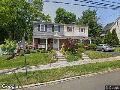
157 W Ashland St Doylestown, PA 18901
Estimated Value: $445,632 - $589,000
3
Beds
2
Baths
1,120
Sq Ft
$451/Sq Ft
Est. Value
About This Home
This home is located at 157 W Ashland St, Doylestown, PA 18901 and is currently estimated at $504,908, approximately $450 per square foot. 157 W Ashland St is a home located in Bucks County with nearby schools including Doyle El School, Lenape Middle School, and Central Bucks High School-West.
Ownership History
Date
Name
Owned For
Owner Type
Purchase Details
Closed on
Oct 22, 2007
Sold by
Mcgowan Robert V and Mcgowan Kellie A
Bought by
Chalfont Storage Inc
Current Estimated Value
Purchase Details
Closed on
May 12, 2005
Sold by
Mellinger William D and Mellinger Peggy A
Bought by
Mcgowan Robert and Mcgowan Kellie A
Home Financials for this Owner
Home Financials are based on the most recent Mortgage that was taken out on this home.
Original Mortgage
$215,920
Interest Rate
5.12%
Mortgage Type
Fannie Mae Freddie Mac
Create a Home Valuation Report for This Property
The Home Valuation Report is an in-depth analysis detailing your home's value as well as a comparison with similar homes in the area
Home Values in the Area
Average Home Value in this Area
Purchase History
| Date | Buyer | Sale Price | Title Company |
|---|---|---|---|
| Chalfont Storage Inc | $289,000 | None Available | |
| Mcgowan Robert | $269,900 | Fidelity Natl Title Ins Co |
Source: Public Records
Mortgage History
| Date | Status | Borrower | Loan Amount |
|---|---|---|---|
| Previous Owner | Mcgowan Robert | $53,980 | |
| Previous Owner | Mcgowan Robert | $215,920 |
Source: Public Records
Tax History Compared to Growth
Tax History
| Year | Tax Paid | Tax Assessment Tax Assessment Total Assessment is a certain percentage of the fair market value that is determined by local assessors to be the total taxable value of land and additions on the property. | Land | Improvement |
|---|---|---|---|---|
| 2024 | $3,927 | $21,800 | $4,110 | $17,690 |
| 2023 | $3,742 | $21,800 | $4,110 | $17,690 |
| 2022 | $3,690 | $21,800 | $4,110 | $17,690 |
| 2021 | $3,649 | $21,800 | $4,110 | $17,690 |
| 2020 | $3,609 | $21,800 | $4,110 | $17,690 |
| 2019 | $3,569 | $21,800 | $4,110 | $17,690 |
| 2018 | $2,976 | $18,400 | $4,120 | $14,280 |
| 2017 | $2,944 | $18,400 | $4,120 | $14,280 |
| 2016 | $2,944 | $18,400 | $4,120 | $14,280 |
| 2015 | -- | $18,400 | $4,120 | $14,280 |
| 2014 | -- | $18,400 | $4,120 | $14,280 |
Source: Public Records
Map
Nearby Homes
- 175 W Oakland Ave
- 277 W Oakland Ave
- 276 W Ashland St
- 84 S Clinton St
- 273 W Court St
- 267 W Court St
- 275 W Court St
- 388 W Oakland Ave
- 36 S Clinton St
- 83 S Hamilton St
- 37 N Clinton St
- 4 Steeplechase Dr
- 69 E Oakland Ave
- 9 Mill Creek Dr
- 72 Bennett Dr
- 124 E Oakland Ave
- 10 Barnes Ct
- 142 Homestead Dr
- 248 Avenue A
- 34 Elfman Dr
- 157 W Ashland St
- 155 W Ashland St
- 157 S West St
- 155 S West St
- 149 W Ashland St
- 151 S West St
- 147 W Ashland St
- 165 W Ashland St
- 155 Bunker St
- 196 W Ashland St
- 145 Bunker St
- 266 Paine St
- 149 S West St
- 133 W Ashland St
- 147 S West St
- 137 Worthington St
- 143 S West St
- 131 W Ashland St
- 265 Paine St
- 270 Paine St