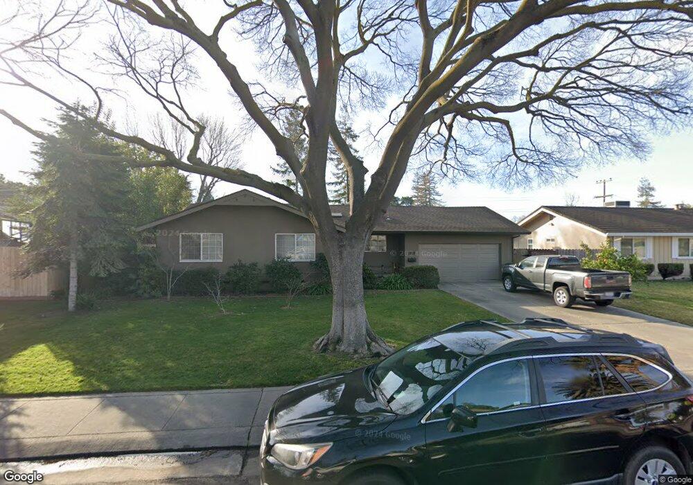
1570 Cameron Way Stockton, CA 95207
Parkwoods NeighborhoodEstimated Value: $432,000 - $524,000
3
Beds
2
Baths
1,542
Sq Ft
$307/Sq Ft
Est. Value
About This Home
This home is located at 1570 Cameron Way, Stockton, CA 95207 and is currently estimated at $473,595, approximately $307 per square foot. 1570 Cameron Way is a home located in San Joaquin County with nearby schools including Lincoln Elementary School, Sierra Middle School, and Lincoln High School.
Ownership History
Date
Name
Owned For
Owner Type
Purchase Details
Closed on
Jul 12, 2022
Sold by
Ray Height Michael and Ray Edwina
Bought by
2022 Height Family Trust
Current Estimated Value
Purchase Details
Closed on
Feb 23, 1994
Sold by
Dalessandro Donald K
Bought by
Height Michael Ray and Height Edwina
Home Financials for this Owner
Home Financials are based on the most recent Mortgage that was taken out on this home.
Original Mortgage
$162,150
Interest Rate
6.98%
Mortgage Type
VA
Create a Home Valuation Report for This Property
The Home Valuation Report is an in-depth analysis detailing your home's value as well as a comparison with similar homes in the area
Home Values in the Area
Average Home Value in this Area
Purchase History
| Date | Buyer | Sale Price | Title Company |
|---|---|---|---|
| 2022 Height Family Trust | -- | None Listed On Document | |
| Height Michael Ray | $159,000 | Fidelity National Title Co |
Source: Public Records
Mortgage History
| Date | Status | Borrower | Loan Amount |
|---|---|---|---|
| Previous Owner | Height Michael Ray | $162,150 |
Source: Public Records
Tax History Compared to Growth
Tax History
| Year | Tax Paid | Tax Assessment Tax Assessment Total Assessment is a certain percentage of the fair market value that is determined by local assessors to be the total taxable value of land and additions on the property. | Land | Improvement |
|---|---|---|---|---|
| 2025 | $3,199 | $270,187 | $110,453 | $159,734 |
| 2024 | $3,132 | $264,890 | $108,288 | $156,602 |
| 2023 | $3,108 | $259,697 | $106,165 | $153,532 |
| 2022 | $3,007 | $254,606 | $104,084 | $150,522 |
| 2021 | $2,967 | $249,615 | $102,044 | $147,571 |
| 2020 | $2,965 | $247,056 | $100,998 | $146,058 |
| 2019 | $2,919 | $242,213 | $99,018 | $143,195 |
| 2018 | $2,865 | $237,465 | $97,077 | $140,388 |
| 2017 | $2,807 | $232,810 | $95,174 | $137,636 |
| 2016 | $2,777 | $228,245 | $93,308 | $134,937 |
| 2014 | $2,453 | $198,000 | $59,000 | $139,000 |
Source: Public Records
Map
Nearby Homes
- 1720 Mcclellan Way
- 1607 Stanton Way
- 1214 Mcclellan Way
- 1152 Stanton Way
- 1703 Polk Way
- 1489 W Swain Rd
- 1633 Porter Way
- 1005 W Benjamin Holt Dr
- 1629 Porter Way
- 2039 W Benjamin Holt Dr
- 1132 Douglas Rd
- 1864 Polk Way
- 1583 W Swain Rd
- 1860 Douglas Rd
- 2025 W Lincoln Rd
- 1467 W Swain Rd
- 1906 Meadow Ave
- 1417 W Swain Rd
- 1707 W Swain Rd Unit 5
- 2014 Douglas Rd
- 1556 Cameron Way
- 1618 Cameron Way
- 1613 Seward Way
- 1621 Seward Way
- 1607 Seward Way
- 1542 Cameron Way
- 1609 Cameron Way
- 1557 Cameron Way
- 1631 Cameron Way
- 1531 Seward Way
- 1543 Cameron Way
- 1532 Cameron Way Unit 29
- 1638 Cameron Way
- 1621 Cameron Way
- 1637 Seward Way
- 1523 Seward Way
- 1558 Stanton Way
- 1610 Stanton Way
- 1533 Cameron Way
- 1610 Seward Way