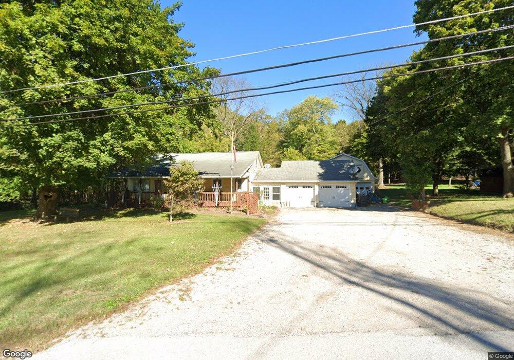
15705 State Route 113 Wakeman, OH 44889
Estimated Value: $267,000 - $321,821
3
Beds
1
Bath
1,592
Sq Ft
$188/Sq Ft
Est. Value
About This Home
This home is located at 15705 State Route 113, Wakeman, OH 44889 and is currently estimated at $298,705, approximately $187 per square foot. 15705 State Route 113 is a home located in Erie County with nearby schools including Firelands Elementary School, Firelands Middle School, and Firelands High School.
Ownership History
Date
Name
Owned For
Owner Type
Purchase Details
Closed on
Aug 10, 2023
Sold by
Lohiser Vera L
Bought by
Lohiser Kenneth R
Current Estimated Value
Home Financials for this Owner
Home Financials are based on the most recent Mortgage that was taken out on this home.
Original Mortgage
$227,920
Outstanding Balance
$222,420
Interest Rate
6.5%
Mortgage Type
FHA
Estimated Equity
$76,285
Purchase Details
Closed on
Feb 2, 2005
Sold by
Griffin Helen L
Bought by
Lohiser Kenneth R and Mcewen Vera L
Home Financials for this Owner
Home Financials are based on the most recent Mortgage that was taken out on this home.
Original Mortgage
$29,600
Interest Rate
5.78%
Mortgage Type
Stand Alone Second
Create a Home Valuation Report for This Property
The Home Valuation Report is an in-depth analysis detailing your home's value as well as a comparison with similar homes in the area
Home Values in the Area
Average Home Value in this Area
Purchase History
| Date | Buyer | Sale Price | Title Company |
|---|---|---|---|
| Lohiser Kenneth R | -- | None Listed On Document | |
| Lohiser Kenneth R | $148,000 | Midland Title Security Inc |
Source: Public Records
Mortgage History
| Date | Status | Borrower | Loan Amount |
|---|---|---|---|
| Open | Lohiser Kenneth R | $227,920 | |
| Previous Owner | Lohiser Kenneth R | $29,600 | |
| Previous Owner | Lohiser Kenneth R | $118,400 |
Source: Public Records
Tax History Compared to Growth
Tax History
| Year | Tax Paid | Tax Assessment Tax Assessment Total Assessment is a certain percentage of the fair market value that is determined by local assessors to be the total taxable value of land and additions on the property. | Land | Improvement |
|---|---|---|---|---|
| 2024 | $2,372 | $65,422 | $19,096 | $46,326 |
| 2023 | $2,372 | $49,241 | $15,561 | $33,680 |
| 2022 | $2,086 | $49,234 | $15,561 | $33,673 |
| 2021 | $2,069 | $49,230 | $15,560 | $33,670 |
| 2020 | $1,873 | $44,470 | $15,560 | $28,910 |
| 2019 | $1,945 | $44,470 | $15,560 | $28,910 |
| 2018 | $1,999 | $44,470 | $15,560 | $28,910 |
| 2017 | $1,932 | $45,470 | $13,000 | $32,470 |
| 2016 | $1,943 | $45,470 | $13,000 | $32,470 |
| 2015 | $1,906 | $45,470 | $13,000 | $32,470 |
| 2014 | $1,966 | $45,470 | $13,000 | $32,470 |
| 2013 | $1,950 | $45,470 | $13,000 | $32,470 |
Source: Public Records
Map
Nearby Homes
- 15319 State Route 113
- 7218 State Route 60
- 9113 Dean Rd
- 13514 State Route 113
- 15617 Sperry Rd
- V/L Baird Rd
- 9708 Harrison Rd
- 13917 Mason Rd
- 13111 Harmon Rd
- Lot B Gifford Rd
- 9839 Gifford Rd
- 51232 N Ridge Rd
- V/L Darrow Rd
- 11909 Joppa Rd
- 50963 Becker Rd
- 11135 Baumhart Rd
- 13612 Thompson Rd
- 48375 Telegraph Rd
- 0 Baumhart Rd
- 13310 Baumhart Rd
- 15715 State Route 113
- 15712 State Route 113
- 15701 State Route 113
- 15640 State Route 113
- 15607 State Route 113
- 0 Dean Unit 3786290
- 15724 State Route 113
- 10710 Green Rd
- 108 Ferndale Dr
- 110 Ferndale Dr
- 110 Ferndale Dr
- 106 Ferndale Dr
- 15607 Ohio 113
- 117 Cliffside Dr Unit 117
- 104 Ferndale Dr
- 111 Cliffside Dr
- 113 Cliffside Dr
- 10608 Dean Rd
- 0 Dean Unit 2470692
- 0 Dean Unit 2507325