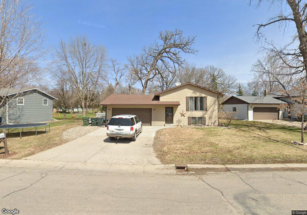
1575 McDonald Dr SW Hutchinson, MN 55350
Estimated Value: $239,026 - $294,000
3
Beds
2
Baths
822
Sq Ft
$315/Sq Ft
Est. Value
About This Home
This home is located at 1575 McDonald Dr SW, Hutchinson, MN 55350 and is currently estimated at $258,757, approximately $314 per square foot. 1575 McDonald Dr SW is a home located in McLeod County with nearby schools including Hutchinson West Elementary School, Hutchinson Park Elementary School, and Hutchinson Middle School.
Ownership History
Date
Name
Owned For
Owner Type
Purchase Details
Closed on
Aug 24, 2018
Sold by
Wendolek Jesse and Wendolek Breann M
Bought by
Maus Patrick L and Maus Brandi M
Current Estimated Value
Home Financials for this Owner
Home Financials are based on the most recent Mortgage that was taken out on this home.
Original Mortgage
$134,550
Outstanding Balance
$116,851
Interest Rate
4.5%
Mortgage Type
New Conventional
Estimated Equity
$141,906
Create a Home Valuation Report for This Property
The Home Valuation Report is an in-depth analysis detailing your home's value as well as a comparison with similar homes in the area
Home Values in the Area
Average Home Value in this Area
Purchase History
| Date | Buyer | Sale Price | Title Company |
|---|---|---|---|
| Maus Patrick L | $149,500 | Title Mark Llc |
Source: Public Records
Mortgage History
| Date | Status | Borrower | Loan Amount |
|---|---|---|---|
| Open | Maus Patrick L | $134,550 |
Source: Public Records
Tax History Compared to Growth
Tax History
| Year | Tax Paid | Tax Assessment Tax Assessment Total Assessment is a certain percentage of the fair market value that is determined by local assessors to be the total taxable value of land and additions on the property. | Land | Improvement |
|---|---|---|---|---|
| 2024 | $2,406 | $192,400 | $61,100 | $131,300 |
| 2023 | $2,442 | $187,700 | $61,100 | $126,600 |
| 2022 | $2,196 | $179,100 | $58,100 | $121,000 |
| 2021 | $2,016 | $151,500 | $50,600 | $100,900 |
| 2020 | $2,070 | $135,700 | $46,000 | $89,700 |
| 2019 | $1,868 | $135,400 | $46,000 | $89,400 |
| 2018 | $1,754 | $0 | $0 | $0 |
| 2017 | $1,622 | $0 | $0 | $0 |
| 2016 | $1,624 | $0 | $0 | $0 |
| 2015 | $1,460 | $0 | $0 | $0 |
| 2014 | -- | $0 | $0 | $0 |
Source: Public Records
Map
Nearby Homes
- 660 Lakewood Dr SW
- 1610 Mahogany Ct SW
- 1020 Roberts Rd SW
- 1053 Prairie View Dr SW
- 1060 Dale St SW
- 1863 Island View Cir
- 966 Osgood Ave SW
- 1095 Blackbird Trail SW
- 1065 Blackbird Trail SW Unit 8
- 702 Southview Ct SW
- 735 Sunset St SW
- 724 Southview Dr SW
- 490 California St NW
- 667 Madson Ave SW
- 642 Juul Rd SW
- 595 Milwaukee Ave SW
- 545 4th Ave SW
- 570 Lynn Rd SW
- XXX 196th Rd
- 230 Lynn Rd SW
- 1575 1575 McDonald Dr SW
- 1565 McDonald Dr SW
- 1585 McDonald Dr SW
- 605 Tyler St SW
- 585 Roberts St SW
- 595 Roberts St SW
- 600 Tyler St SW
- 1545 1545 McDonald-drive-sw
- 1545 1545 McDonald Dr SW
- 1555 McDonald Dr SW
- 605 Roberts St SW
- 605 605 Roberts-Street-sw
- 600 Park Island Dr SW
- 615 Tyler St SW
- 610 610 Park Island-Drive-sw
- 610 Park Island Dr SW
- 625 625 Sw Tyler St SW
- 607 Roberts St SW
- 607 Roberts St SW
- 610 Tyler St SW