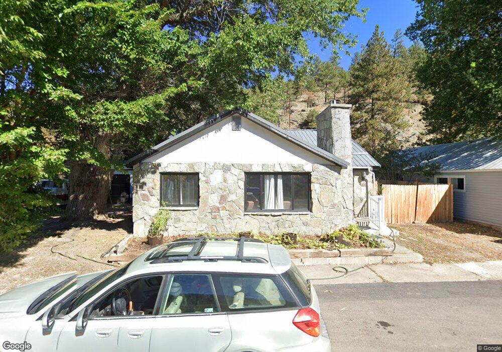
1576 Mount Highway 434 Wolf Creek, MT 59648
Estimated Value: $546,000 - $926,000
5
Beds
3
Baths
4,160
Sq Ft
$181/Sq Ft
Est. Value
About This Home
This home is located at 1576 Mount Highway 434, Wolf Creek, MT 59648 and is currently estimated at $753,381, approximately $181 per square foot. 1576 Mount Highway 434 is a home located in Lewis and Clark County.
Ownership History
Date
Name
Owned For
Owner Type
Purchase Details
Closed on
Mar 25, 2023
Sold by
Eror Steven Charles and Tsai Cynthia
Bought by
Eror Steven Charles and Tsai Cynthia
Current Estimated Value
Purchase Details
Closed on
Nov 26, 2018
Sold by
Rossberg Peggy Ann
Bought by
Eror Steven C and Tsai Cynthia
Home Financials for this Owner
Home Financials are based on the most recent Mortgage that was taken out on this home.
Original Mortgage
$405,000
Interest Rate
4.9%
Mortgage Type
New Conventional
Create a Home Valuation Report for This Property
The Home Valuation Report is an in-depth analysis detailing your home's value as well as a comparison with similar homes in the area
Home Values in the Area
Average Home Value in this Area
Purchase History
| Date | Buyer | Sale Price | Title Company |
|---|---|---|---|
| Eror Steven Charles | -- | None Listed On Document | |
| Eror Steven Charles | -- | None Listed On Document | |
| Eror Steven Charles | -- | None Listed On Document | |
| Eror Steven C | -- | First Montana Land Title Co |
Source: Public Records
Mortgage History
| Date | Status | Borrower | Loan Amount |
|---|---|---|---|
| Previous Owner | Eror Steven C | $405,000 |
Source: Public Records
Tax History Compared to Growth
Tax History
| Year | Tax Paid | Tax Assessment Tax Assessment Total Assessment is a certain percentage of the fair market value that is determined by local assessors to be the total taxable value of land and additions on the property. | Land | Improvement |
|---|---|---|---|---|
| 2025 | $1,941 | $552,352 | $0 | $0 |
| 2024 | $2,417 | $425,673 | $0 | $0 |
| 2023 | $2,581 | $425,673 | $0 | $0 |
| 2022 | $2,269 | $312,848 | $0 | $0 |
| 2021 | $2,072 | $312,848 | $0 | $0 |
| 2020 | $2,213 | $304,875 | $0 | $0 |
| 2019 | $2,253 | $304,875 | $0 | $0 |
| 2018 | $2,193 | $297,910 | $0 | $0 |
| 2017 | $1,897 | $297,910 | $0 | $0 |
| 2016 | $1,985 | $283,141 | $0 | $0 |
| 2015 | $1,827 | $283,141 | $0 | $0 |
| 2014 | $1,777 | $145,513 | $0 | $0 |
Source: Public Records
Map
Nearby Homes
- 300 Wolf Creek Main St
- tbd Gladstone Creek
- 215 Recreation Rd
- 0 Gladstone Creek Rd
- 1980 N Lyons Creek Rd
- 2270 Lynx Trail Dr
- 2155 Craig River Rd Unit 2 Parcels of land
- 1348 Beartooth Rd
- 4253 Woods Creek Rd
- 3925 Little Wolf Creek Rd
- 2660 Olywood Ct
- 1872 Beartooth Rd
- 4540 Denton Gulch Rd
- 2755 Sevenmile Rd
- 220 Leonard St
- Tbd Beartooth Rd
- 1350 Beartooth Rd
- NHN Little Wolf Creek Rd
- 5700 Sperry Dr
- Tbd Powerline Rd
- 1576 Mt Highway 434
- 1576 Mt Highway 434
- 1580 Mt Highway 434
- 1580 Mt Highway 434
- 1570 Mt Highway 434
- 1568 Mt Highway 434
- 1568 Mt Highway 434
- 1560 Mount Highway 434
- 1590 Mt Highway 434
- 1590 Mt Highway 434
- 1540 Mt Highway 434
- 1540 Mt Highway 434
- 1540 Mount Highway 434
- 1537 Mt Highway 434
- 1533 Mt Highway 434
- 1512 Mt Highway 434
- 1505 Mt Highway 434
- 1920 Little Wolf Creek Rd
- 1454 State Highway 434
- 1454 Mount Highway 434