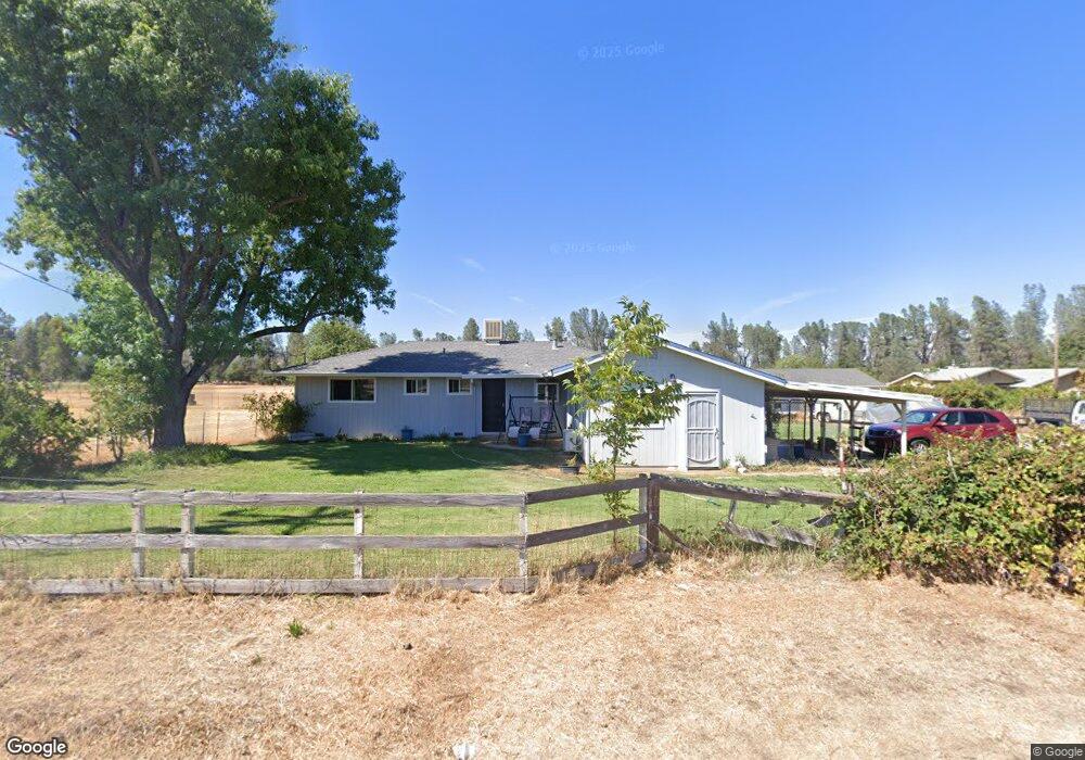
15760 Cloverdale Rd Anderson, CA 96007
Estimated Value: $285,000 - $365,000
3
Beds
2
Baths
1,200
Sq Ft
$267/Sq Ft
Est. Value
About This Home
This home is located at 15760 Cloverdale Rd, Anderson, CA 96007 and is currently estimated at $320,603, approximately $267 per square foot. 15760 Cloverdale Rd is a home located in Shasta County.
Ownership History
Date
Name
Owned For
Owner Type
Purchase Details
Closed on
Jan 26, 2018
Sold by
Dalton Matthew J and Dalton Pamela D
Bought by
Dalton Matthew James and Dalton Pamela Dee
Current Estimated Value
Purchase Details
Closed on
Sep 27, 2001
Sold by
Williams Mark E
Bought by
Dalton Matthew J and Dalton Pamela D
Home Financials for this Owner
Home Financials are based on the most recent Mortgage that was taken out on this home.
Original Mortgage
$139,313
Outstanding Balance
$54,572
Interest Rate
6.9%
Mortgage Type
FHA
Estimated Equity
$266,031
Purchase Details
Closed on
Apr 16, 2001
Sold by
Williams Melanie D
Bought by
Williams Mark E
Create a Home Valuation Report for This Property
The Home Valuation Report is an in-depth analysis detailing your home's value as well as a comparison with similar homes in the area
Home Values in the Area
Average Home Value in this Area
Purchase History
| Date | Buyer | Sale Price | Title Company |
|---|---|---|---|
| Dalton Matthew James | -- | None Available | |
| Dalton Matthew J | $141,500 | First American Title Co | |
| Williams Mark E | -- | -- |
Source: Public Records
Mortgage History
| Date | Status | Borrower | Loan Amount |
|---|---|---|---|
| Open | Dalton Matthew J | $139,313 |
Source: Public Records
Tax History Compared to Growth
Tax History
| Year | Tax Paid | Tax Assessment Tax Assessment Total Assessment is a certain percentage of the fair market value that is determined by local assessors to be the total taxable value of land and additions on the property. | Land | Improvement |
|---|---|---|---|---|
| 2025 | $2,348 | $218,493 | $59,078 | $159,415 |
| 2024 | $2,306 | $215,120 | $57,920 | $157,200 |
| 2023 | $2,306 | $211,087 | $56,785 | $154,302 |
| 2022 | $2,249 | $207,083 | $55,672 | $151,411 |
| 2021 | $2,229 | $203,716 | $54,581 | $149,135 |
| 2020 | $2,219 | $202,574 | $54,022 | $148,552 |
| 2019 | $2,185 | $199,461 | $52,963 | $146,498 |
| 2018 | $2,092 | $192,251 | $51,925 | $140,326 |
| 2017 | $2,087 | $187,752 | $50,907 | $136,845 |
| 2016 | $1,958 | $175,944 | $49,909 | $126,035 |
| 2015 | $1,964 | $173,302 | $49,160 | $124,142 |
| 2014 | $1,793 | $156,000 | $39,000 | $117,000 |
Source: Public Records
Map
Nearby Homes
- 15557 Cloverdale Rd
- 15947 Butterfield Ln
- 6400 Dale Ln
- 0 Cloverdale Rd Unit SN25180858
- 40 Acres Heavenly Valley Ln
- 3.97 Acres Renshaw Ln
- 5941 Oak St
- 16433 China Gulch Dr
- 6703 High Valley Rd
- 16325 Tacoma Ln
- 17895 Duck Canyon Rd
- 17795 Duck Canyon Rd
- 16832 Bunny Ln
- 16837 Dot Ln
- 14485 Small Farms Rd
- 6513 Lulu Ln
- 16880 Laverne Ln
- 0 Lower Coal Pit Rd Unit 25-4389
- 16840 Hawthorne Ave
- 0 Lower Coal Pit Dr Unit 25-3995
- 15742 Cloverdale Rd
- 15772 Cloverdale Rd
- 15751 Cloverdale Rd
- 15707 Cloverdale Rd
- 15775 Cloverdale Rd
- 16190 Cloverdale Rd
- 0 Cloverdale Rd
- 15710 Cloverdale Rd
- 15795 Cloverdale Rd
- 15829 Cloverdale Rd
- 15866 Cloverdale Rd
- 15690 Cloverdale Rd
- 15680 Cloverdale Rd
- 15801 Cloverdale Rd
- 15805 Cloverdale Rd
- 15644 Cloverdale Rd
- 15863 Cloverdale Rd
- 15671 Cloverdale Rd
- 6454 Clovermarie Ln
- 15657 Cloverdale Rd