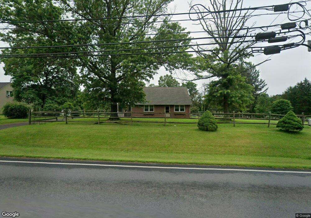
158 Cowpath Rd Souderton, PA 18964
Estimated Value: $450,000 - $496,000
3
Beds
1
Bath
1,733
Sq Ft
$273/Sq Ft
Est. Value
About This Home
This home is located at 158 Cowpath Rd, Souderton, PA 18964 and is currently estimated at $472,764, approximately $272 per square foot. 158 Cowpath Rd is a home located in Montgomery County with nearby schools including West Broad Street Elementary School, Indian Crest Middle School, and Souderton Area Senior High School.
Ownership History
Date
Name
Owned For
Owner Type
Purchase Details
Closed on
Jul 31, 2001
Sold by
Schilling Walter A
Bought by
Lewis John and Lewis Jamie
Current Estimated Value
Purchase Details
Closed on
Jan 31, 1994
Sold by
Delp Grace
Bought by
Schilling Walter A
Create a Home Valuation Report for This Property
The Home Valuation Report is an in-depth analysis detailing your home's value as well as a comparison with similar homes in the area
Home Values in the Area
Average Home Value in this Area
Purchase History
| Date | Buyer | Sale Price | Title Company |
|---|---|---|---|
| Lewis John | $184,000 | -- | |
| Schilling Walter A | $142,000 | -- |
Source: Public Records
Tax History Compared to Growth
Tax History
| Year | Tax Paid | Tax Assessment Tax Assessment Total Assessment is a certain percentage of the fair market value that is determined by local assessors to be the total taxable value of land and additions on the property. | Land | Improvement |
|---|---|---|---|---|
| 2025 | $5,970 | $148,640 | $61,030 | $87,610 |
| 2024 | $5,970 | $148,640 | $61,030 | $87,610 |
| 2023 | $5,696 | $148,640 | $61,030 | $87,610 |
| 2022 | $5,522 | $148,640 | $61,030 | $87,610 |
| 2021 | $5,406 | $148,640 | $61,030 | $87,610 |
| 2020 | $5,333 | $148,640 | $61,030 | $87,610 |
| 2019 | $4,868 | $148,640 | $61,030 | $87,610 |
| 2018 | $5,269 | $148,640 | $61,030 | $87,610 |
| 2017 | $5,136 | $148,640 | $61,030 | $87,610 |
| 2016 | $5,078 | $148,640 | $61,030 | $87,610 |
| 2015 | $4,941 | $148,640 | $61,030 | $87,610 |
| 2014 | $4,941 | $148,640 | $61,030 | $87,610 |
Source: Public Records
Map
Nearby Homes
- 510 Berkshire Dr
- 723 Finlay Dr
- 708 Finlay Dr
- 35 Chancery Ct Unit 35
- 51 Cambridge Ct Unit 51
- 124 Hollybush Cir
- 44 Adams Ave
- Arcadia Plan at Glenwood Chase
- Sebastian Plan at Glenwood Chase
- Arcadia Plan at Retreat at Boyertown Farms
- Caldwell Plan at Glenwood Chase
- Magnolia Plan at Glenwood Chase
- Harrison Plan at Glenwood Chase
- Savannah Plan at Retreat at Boyertown Farms
- Nottingham Plan at Penshyre Place
- Covington Plan at Glenwood Chase
- Woodford Plan at Penshyre Place
- Devonshire Plan at Retreat at Boyertown Farms
- Woodford Plan at Retreat at Boyertown Farms
- Kipling Plan at Retreat at Boyertown Farms
- 164 Cowpath Rd
- 152 Cowpath Rd
- 170 Cowpath Rd
- 183 Cowpath Rd
- 180 Cowpath Rd
- 144 Cowpath Rd
- 191 Cowpath Rd
- 188 Cowpath Rd
- 382 W Broad St
- 142 Cowpath Rd
- 335 Meadow Wood Ln
- 391 W Broad St
- 339 Meadow Wood Ln
- 138 Cowpath Rd
- 385 W Broad St
- 370 W Broad St
- 382 Meadow Wood Ln
- 344 Meadow Wood Ln
- 372 W Broad St
- 379 W Broad St