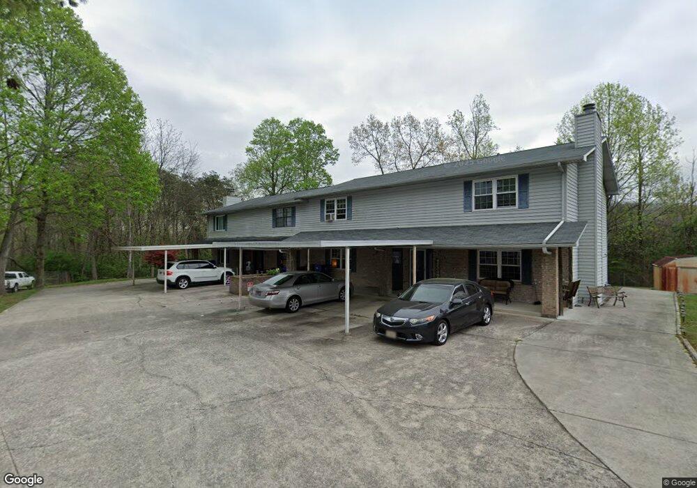
158 High Point Ln Oak Ridge, TN 37830
Estimated Value: $250,000 - $290,000
3
Beds
3
Baths
1,462
Sq Ft
$184/Sq Ft
Est. Value
About This Home
This home is located at 158 High Point Ln, Oak Ridge, TN 37830 and is currently estimated at $268,642, approximately $183 per square foot. 158 High Point Ln is a home located in Anderson County with nearby schools including Woodland Elementary School, Jefferson Middle School, and Oak Ridge High School.
Ownership History
Date
Name
Owned For
Owner Type
Purchase Details
Closed on
Dec 9, 2019
Sold by
Mioduszewski Saskia and Peter K Mioduszewski Testament
Bought by
Mioduszewski Saskia and Kristina Mioduszewski Special
Current Estimated Value
Purchase Details
Closed on
Jul 26, 2010
Sold by
Alexander Phillip
Bought by
Mioduszewski Peter
Purchase Details
Closed on
Nov 1, 2000
Sold by
Pai Rajendra P
Bought by
Alexander Phillip
Purchase Details
Closed on
Oct 28, 1993
Sold by
Rao Saligrama
Bought by
Pai Rajendra
Purchase Details
Closed on
Oct 8, 1990
Bought by
Rao Saligrama Kote A and Rao Wife Shantha Rao
Create a Home Valuation Report for This Property
The Home Valuation Report is an in-depth analysis detailing your home's value as well as a comparison with similar homes in the area
Home Values in the Area
Average Home Value in this Area
Purchase History
| Date | Buyer | Sale Price | Title Company |
|---|---|---|---|
| Mioduszewski Saskia | -- | None Available | |
| Mioduszewski Peter | $104,000 | -- | |
| Alexander Phillip | $73,500 | -- | |
| Pai Rajendra | $75,000 | -- | |
| Rao Saligrama Kote A | $67,700 | -- |
Source: Public Records
Tax History Compared to Growth
Tax History
| Year | Tax Paid | Tax Assessment Tax Assessment Total Assessment is a certain percentage of the fair market value that is determined by local assessors to be the total taxable value of land and additions on the property. | Land | Improvement |
|---|---|---|---|---|
| 2024 | $716 | $29,150 | $2,150 | $27,000 |
| 2023 | $716 | $29,150 | $0 | $0 |
| 2022 | $1,390 | $29,150 | $2,150 | $27,000 |
| 2021 | $1,390 | $29,150 | $2,150 | $27,000 |
| 2020 | $1,196 | $29,150 | $2,150 | $27,000 |
| 2019 | $1,224 | $23,300 | $1,650 | $21,650 |
| 2018 | $1,197 | $23,300 | $1,650 | $21,650 |
| 2017 | $1,192 | $23,300 | $1,650 | $21,650 |
| 2016 | $1,192 | $23,300 | $1,650 | $21,650 |
| 2015 | -- | $23,300 | $1,650 | $21,650 |
| 2014 | -- | $23,300 | $1,650 | $21,650 |
| 2013 | -- | $25,200 | $0 | $0 |
Source: Public Records
Map
Nearby Homes
- 162 High Point Ln
- 160 High Point Ln
- 119 Hanover Place
- 113 High Point Ln
- 98 Hampshire Cir
- 0 Hendrix Dr
- 123 Heritage Dr
- 101 Hendrix Dr
- 105 Deerfield Ln
- 103 S Purdue Ave
- 121 Goucher Cir
- 112 Nasson Ln
- 116 W Gettysburg Ave
- 109 Nasson Ln
- 191 Manhattan Ave
- 124 Marshall Cir
- 207 Manhattan Ave
- 140 Brandeis Ln
- 107 Townsend Rd
- 185 S Purdue Ave
- 156 High Point Ln
- 154 High Point Ln
- 121 Crossroads Blvd
- 152 High Point Ln
- 150 High Point Ln
- 119 Crossroads Blvd
- 157 High Point Ln
- 123 Crossroads Blvd
- 159 High Point Ln
- 155 High Point Ln
- 148 High Point Ln
- 153 High Point Ln
- 151 High Point Ln
- 146 High Point Ln
- 125 Crossroads Blvd
- 144 High Point Ln
- 149 High Point Ln
- 100 Crystal Cove Ln
- 147 High Point Ln
- 101 Wolf Creek Way