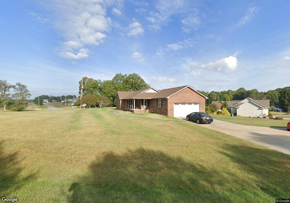
158 Pear Tree Rd Troutman, NC 28166
Estimated Value: $317,000 - $432,000
3
Beds
2
Baths
1,537
Sq Ft
$240/Sq Ft
Est. Value
About This Home
This home is located at 158 Pear Tree Rd, Troutman, NC 28166 and is currently estimated at $368,853, approximately $239 per square foot. 158 Pear Tree Rd is a home located in Iredell County with nearby schools including Troutman Elementary School, Troutman Middle School, and South Iredell High School.
Ownership History
Date
Name
Owned For
Owner Type
Purchase Details
Closed on
Jul 25, 2002
Sold by
Lancaster John L and Lancaster Karen E
Bought by
Bacon Robert B
Current Estimated Value
Home Financials for this Owner
Home Financials are based on the most recent Mortgage that was taken out on this home.
Original Mortgage
$118,800
Outstanding Balance
$49,246
Interest Rate
6.67%
Estimated Equity
$319,607
Purchase Details
Closed on
Nov 24, 1998
Sold by
Keith Kelly W and Keith Peggy R
Bought by
Lancaster John L and Lancaster Karen E
Home Financials for this Owner
Home Financials are based on the most recent Mortgage that was taken out on this home.
Original Mortgage
$118,300
Interest Rate
6.95%
Create a Home Valuation Report for This Property
The Home Valuation Report is an in-depth analysis detailing your home's value as well as a comparison with similar homes in the area
Home Values in the Area
Average Home Value in this Area
Purchase History
| Date | Buyer | Sale Price | Title Company |
|---|---|---|---|
| Bacon Robert B | $148,500 | -- | |
| Lancaster John L | $148,000 | -- |
Source: Public Records
Mortgage History
| Date | Status | Borrower | Loan Amount |
|---|---|---|---|
| Open | Bacon Robert B | $118,800 | |
| Previous Owner | Lancaster John L | $118,300 |
Source: Public Records
Tax History Compared to Growth
Tax History
| Year | Tax Paid | Tax Assessment Tax Assessment Total Assessment is a certain percentage of the fair market value that is determined by local assessors to be the total taxable value of land and additions on the property. | Land | Improvement |
|---|---|---|---|---|
| 2025 | $1,673 | $268,860 | $50,000 | $218,860 |
| 2024 | $1,743 | $268,860 | $50,000 | $218,860 |
| 2023 | $1,673 | $268,860 | $50,000 | $218,860 |
| 2022 | $1,354 | $206,830 | $36,500 | $170,330 |
| 2021 | $1,354 | $206,830 | $36,500 | $170,330 |
| 2020 | $1,252 | $190,580 | $36,500 | $154,080 |
| 2019 | $1,182 | $186,870 | $36,500 | $150,370 |
| 2018 | $1,087 | $173,280 | $36,500 | $136,780 |
| 2017 | $1,087 | $173,280 | $36,500 | $136,780 |
| 2016 | $1,068 | $170,060 | $36,500 | $133,560 |
| 2015 | $1,068 | $170,060 | $36,500 | $133,560 |
| 2014 | $1,075 | $185,910 | $35,000 | $150,910 |
Source: Public Records
Map
Nearby Homes
- 173 Painted Bunting Dr
- 125 Apple Tree Ln Unit 15-16
- 105 Apple Tree Ln Unit 12
- 0 Hoover Rd
- 129-131 Shermill Ln
- 505 Cedar St
- 340 Field Dr
- 214 Astor St
- 213 Cassius Dr
- 00 Byers Rd
- 236 Cassius Dr
- 146 Arden Ct
- 131 Autumn Leaf Rd
- Elijah Plan at Norman Creek - Townhomes
- Wilmington Plan at Norman Creek
- Raleigh Plan at Norman Creek
- Southampton Plan at Norman Creek - Townhomes
- Newberry Plan at Norman Creek
- Stapleton Plan at Norman Creek - Townhomes
- Cary Plan at Norman Creek - Townhomes
- 115 Gray Barn Dr
- 162 Pear Tree Rd
- 148 Pear Tree Rd
- 108 Gray Barn Dr
- 149 Pear Tree Rd
- 114 Gray Barn Dr
- 125 Gray Barn Dr
- 122 Gray Barn Dr
- 145 Pear Tree Rd
- 142 Pear Tree Rd
- 141 Gray Barn Dr
- 141 Gray Barn Dr Unit 11
- 174 Pear Tree Rd
- 157 Gray Barn Dr Unit 36
- 157 Gray Barn Dr
- 133 Windstone Dr Unit 8
- 129 Windstone Dr Unit Lot 7
- 129 Windstone Dr Unit 9
- 129 Windstone Dr
- 137 Windstone Dr Unit 9