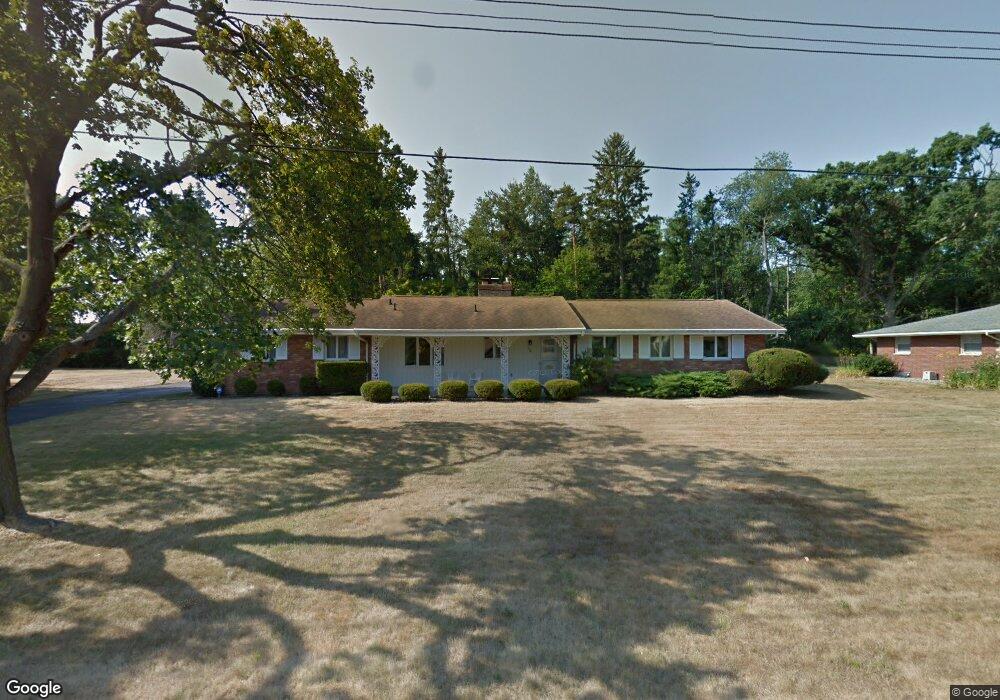
158 Stafford Ave Battle Creek, MI 49015
Minges Brook Riverside NeighborhoodEstimated Value: $276,312 - $313,000
4
Beds
3
Baths
1,640
Sq Ft
$182/Sq Ft
Est. Value
About This Home
This home is located at 158 Stafford Ave, Battle Creek, MI 49015 and is currently estimated at $297,828, approximately $181 per square foot. 158 Stafford Ave is a home located in Calhoun County with nearby schools including Lakeview Middle School, Lakeview High School, and Arbor Academy.
Ownership History
Date
Name
Owned For
Owner Type
Purchase Details
Closed on
Dec 21, 2016
Sold by
Adie Madeline A
Bought by
Ure Eric J and Ure Helen
Current Estimated Value
Purchase Details
Closed on
Dec 27, 2012
Sold by
Markovich Judy and Magers Thomas Michael
Bought by
Adie Madeline A
Home Financials for this Owner
Home Financials are based on the most recent Mortgage that was taken out on this home.
Original Mortgage
$94,000
Interest Rate
3.32%
Mortgage Type
New Conventional
Create a Home Valuation Report for This Property
The Home Valuation Report is an in-depth analysis detailing your home's value as well as a comparison with similar homes in the area
Home Values in the Area
Average Home Value in this Area
Purchase History
| Date | Buyer | Sale Price | Title Company |
|---|---|---|---|
| Ure Eric J | -- | Attorney | |
| Adie Madeline A | $125,000 | Chicago Title |
Source: Public Records
Mortgage History
| Date | Status | Borrower | Loan Amount |
|---|---|---|---|
| Previous Owner | Adie Madeline A | $94,000 |
Source: Public Records
Tax History Compared to Growth
Tax History
| Year | Tax Paid | Tax Assessment Tax Assessment Total Assessment is a certain percentage of the fair market value that is determined by local assessors to be the total taxable value of land and additions on the property. | Land | Improvement |
|---|---|---|---|---|
| 2025 | -- | $123,200 | $0 | $0 |
| 2024 | $3,116 | $113,967 | $0 | $0 |
| 2023 | $3,548 | $103,643 | $0 | $0 |
| 2022 | $2,815 | $93,043 | $0 | $0 |
| 2021 | $3,456 | $88,095 | $0 | $0 |
| 2020 | $3,251 | $82,636 | $0 | $0 |
| 2019 | $3,238 | $78,747 | $0 | $0 |
| 2018 | $3,238 | $76,361 | $10,189 | $66,172 |
| 2017 | $3,140 | $71,845 | $0 | $0 |
| 2016 | $3,134 | $69,399 | $0 | $0 |
| 2015 | $2,916 | $66,402 | $6,878 | $59,524 |
| 2014 | $2,916 | $65,189 | $6,878 | $58,311 |
Source: Public Records
Map
Nearby Homes
- 239 Brewer Dr S
- 32 Golden Ave
- 117 Meadow Dr
- 1116 Lakeside Dr S
- 620 Meadow Dr
- V/L Riverside Dr
- 582 Riverside Dr
- 20 Hiawatha Dr
- 112 Darragh Dr
- 1200 Lakeside Dr S
- 1 Hiawatha Cove Trail Unit 23
- 245 Columbia Ave E
- 52 E Acacia Blvd
- 677 Morningside Dr
- 0 Jennings Landing
- 225 Columbia Ave W Unit 2
- 206 N Chapel Hill Dr
- 251 Columbia Ave W Unit 1
- 618 Jennings Landing
- 133 Country Club Terrace
- 150 Stafford Ave
- 159 Stafford Ave
- 166 Stafford Ave
- 151 Stafford Ave
- 517 S Brewer Dr
- 267 Martha Dr
- 258 Martha Dr
- 255 Brewer Dr S
- 136 Stafford Ave
- 137 Stafford Ave
- 259 Martha Dr
- 144 Stafford Ave
- 250 Martha Dr
- 128 Stafford Ave
- 247 Brewer Dr S
- 254 Brewer Dr S
- 251 Martha Dr
- 261 Leland Dr S
- 242 Martha Dr
- 246 Brewer Dr S