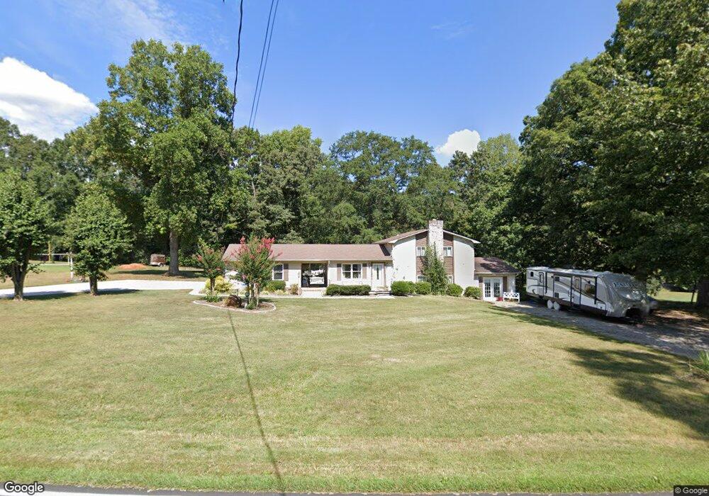
1580 Roseland Dr Lincolnton, NC 28092
Estimated Value: $276,000 - $306,716
3
Beds
2
Baths
1,425
Sq Ft
$207/Sq Ft
Est. Value
About This Home
This home is located at 1580 Roseland Dr, Lincolnton, NC 28092 and is currently estimated at $294,929, approximately $206 per square foot. 1580 Roseland Dr is a home located in Lincoln County with nearby schools including Love Memorial Elementary School, West Lincoln Middle, and West Lincoln High School.
Ownership History
Date
Name
Owned For
Owner Type
Purchase Details
Closed on
Aug 27, 2020
Sold by
Waldrop Cecyl Jackson and Waldrop Sabrina A
Bought by
Rhodes Michael David and Rhodes Amber Reynolds
Current Estimated Value
Purchase Details
Closed on
Mar 15, 2013
Sold by
Reynolds Roy Edward and Reynolds Margaret Ralphine E
Bought by
Rhodes Michael D and Rhodes Amber R
Home Financials for this Owner
Home Financials are based on the most recent Mortgage that was taken out on this home.
Original Mortgage
$112,244
Interest Rate
3.57%
Mortgage Type
New Conventional
Create a Home Valuation Report for This Property
The Home Valuation Report is an in-depth analysis detailing your home's value as well as a comparison with similar homes in the area
Home Values in the Area
Average Home Value in this Area
Purchase History
| Date | Buyer | Sale Price | Title Company |
|---|---|---|---|
| Rhodes Michael David | $5,000 | None Available | |
| Rhodes Michael D | $110,000 | None Available |
Source: Public Records
Mortgage History
| Date | Status | Borrower | Loan Amount |
|---|---|---|---|
| Previous Owner | Rhodes Michael D | $112,244 |
Source: Public Records
Tax History Compared to Growth
Tax History
| Year | Tax Paid | Tax Assessment Tax Assessment Total Assessment is a certain percentage of the fair market value that is determined by local assessors to be the total taxable value of land and additions on the property. | Land | Improvement |
|---|---|---|---|---|
| 2025 | $1,509 | $222,890 | $38,652 | $184,238 |
| 2024 | $1,489 | $222,890 | $38,652 | $184,238 |
| 2023 | $1,419 | $222,890 | $38,652 | $184,238 |
| 2022 | $1,068 | $135,244 | $30,921 | $104,323 |
| 2021 | $1,068 | $135,244 | $30,921 | $104,323 |
| 2020 | $878 | $128,185 | $23,862 | $104,323 |
| 2019 | $878 | $128,185 | $23,862 | $104,323 |
| 2018 | $928 | $118,649 | $21,656 | $96,993 |
| 2017 | $801 | $118,649 | $21,656 | $96,993 |
| 2016 | $801 | $118,649 | $21,656 | $96,993 |
| 2015 | $871 | $118,649 | $21,656 | $96,993 |
| 2014 | $915 | $126,320 | $22,634 | $103,686 |
Source: Public Records
Map
Nearby Homes
- 1547 Roseland Dr
- 1690 Roseland Dr
- 1156 Lyn Well Rd
- 776 S Grove St Unit EXT
- 1431 Boy Scout Rd
- 2130 Drive Inn Rd
- 0 Drive Inn Rd
- 1672 Riverview Rd
- 000 Riverview Rd
- 792 Carolina Mill Cir
- 1218 W Highview Ln
- 00 Glenn St
- 1070 N Carolina 182
- 0 N Carolina 182 Unit CAR4246688
- 792 Mace Ln
- 584 Southside Church Rd
- 515 Willow St
- 697 S Grove St
- 689 S Grove St
- 00 Lake Sylvia Rd
- 1598 Roseland Dr
- 1583 Roseland Dr
- 1567 Roseland Dr
- 1597 Roseland Dr
- 1555 Roseland Dr
- 1610 Roseland Dr
- 1537 Roseland Dr
- 952 Harvey Rd
- 1631 Roseland Dr
- 00 Boy Scout Rd
- 000 Boy Scout Rd
- 1638 Roseland Dr
- 00 Roseland Dr
- 1637 Roseland Dr
- 1202 Petes Rd
- 908 Harvey Rd
- 1112 Petes Rd
- 1722 Roseland Dr
- 1160 Petes Rd
- 1641 Roseland Dr