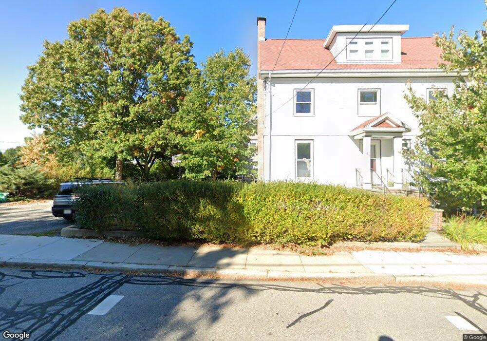
159 Summit Ave Brookline, MA 02446
Washington Square NeighborhoodEstimated Value: $1,828,000 - $2,558,000
3
Beds
2
Baths
1,813
Sq Ft
$1,243/Sq Ft
Est. Value
About This Home
This home is located at 159 Summit Ave, Brookline, MA 02446 and is currently estimated at $2,253,014, approximately $1,242 per square foot. 159 Summit Ave is a home located in Norfolk County with nearby schools including Michael Driscoll, Brookline High School, and Boston Green Academy Horace Mann Charter School.
Ownership History
Date
Name
Owned For
Owner Type
Purchase Details
Closed on
Feb 13, 2017
Sold by
Gibbons Christopher H and Temin Elizabeth S
Bought by
C & E Nt
Current Estimated Value
Purchase Details
Closed on
Feb 7, 2011
Sold by
Temin Elizabeth S
Bought by
Gibbons Christopher H and Temin Elizabeth S
Home Financials for this Owner
Home Financials are based on the most recent Mortgage that was taken out on this home.
Original Mortgage
$88,915
Interest Rate
4.82%
Purchase Details
Closed on
Jun 17, 2002
Sold by
Klapfish Maurice S and Klapfish Anne B
Bought by
Temin Elizabeth S
Home Financials for this Owner
Home Financials are based on the most recent Mortgage that was taken out on this home.
Original Mortgage
$575,000
Interest Rate
6.8%
Mortgage Type
Purchase Money Mortgage
Create a Home Valuation Report for This Property
The Home Valuation Report is an in-depth analysis detailing your home's value as well as a comparison with similar homes in the area
Home Values in the Area
Average Home Value in this Area
Purchase History
| Date | Buyer | Sale Price | Title Company |
|---|---|---|---|
| C & E Nt | -- | -- | |
| Gibbons Christopher H | -- | -- | |
| Temin Elizabeth S | -- | -- | |
| Temin Elizabeth S | $772,500 | -- |
Source: Public Records
Mortgage History
| Date | Status | Borrower | Loan Amount |
|---|---|---|---|
| Previous Owner | Temin Elizabeth S | $88,915 | |
| Previous Owner | Temin Elizabeth S | $575,000 |
Source: Public Records
Tax History
| Year | Tax Paid | Tax Assessment Tax Assessment Total Assessment is a certain percentage of the fair market value that is determined by local assessors to be the total taxable value of land and additions on the property. | Land | Improvement |
|---|---|---|---|---|
| 2025 | $21,688 | $2,197,400 | $1,277,800 | $919,600 |
| 2024 | $20,583 | $2,106,800 | $1,225,200 | $881,600 |
| 2023 | $19,154 | $1,921,200 | $1,055,200 | $866,000 |
| 2022 | $18,550 | $1,820,400 | $1,005,000 | $815,400 |
| 2021 | $17,153 | $1,750,300 | $966,300 | $784,000 |
| 2020 | $15,120 | $1,600,000 | $827,400 | $772,600 |
| 2019 | $14,278 | $1,523,800 | $788,000 | $735,800 |
| 2018 | $12,993 | $1,373,500 | $647,600 | $725,900 |
| 2017 | $12,803 | $1,295,800 | $610,900 | $684,900 |
| 2016 | $12,619 | $1,211,000 | $571,000 | $640,000 |
| 2015 | $11,031 | $1,032,900 | $434,700 | $598,200 |
| 2014 | $11,261 | $988,700 | $401,200 | $587,500 |
Source: Public Records
Map
Nearby Homes
- 150+152 Jordan Rd
- 30 York Terrace
- 200 Winchester St Unit 1
- 19 Westbourne Terrace Unit 2
- 1618 Beacon St Unit 1
- 1620 Beacon St
- 108 Columbia St Unit 1
- 1490 Beacon St Unit 4
- 757 Washington St Unit 2
- 249 Corey Rd Unit 404
- 249 Corey Rd Unit 306
- 249 Corey Rd Unit 303
- 249 Corey Rd Unit 203
- 249 Corey Rd Unit 309
- 249 Corey Rd Unit 207
- 249 Corey Rd Unit 408
- 249 Corey Rd Unit 201
- 249 Corey Rd Unit 401
- 4 Fairbanks St Unit 2
- 15 Short St Unit 4
Your Personal Tour Guide
Ask me questions while you tour the home.