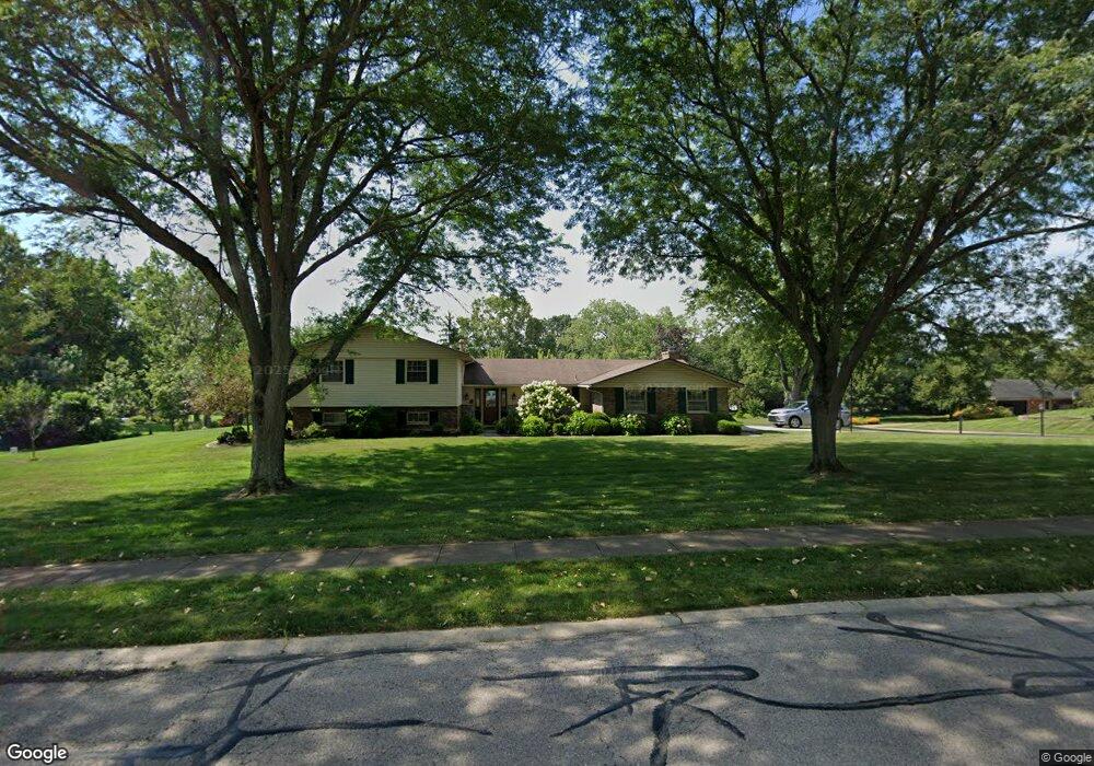
1590 Mapleton Dr Dayton, OH 45459
Estimated Value: $385,221 - $430,000
4
Beds
4
Baths
3,282
Sq Ft
$125/Sq Ft
Est. Value
About This Home
This home is located at 1590 Mapleton Dr, Dayton, OH 45459 and is currently estimated at $410,305, approximately $125 per square foot. 1590 Mapleton Dr is a home located in Montgomery County with nearby schools including Primary Village North, Stingley Elementary School, and Tower Heights Middle School.
Ownership History
Date
Name
Owned For
Owner Type
Purchase Details
Closed on
Oct 11, 2017
Sold by
Thompson Pamela S
Bought by
Phillips Earl B and Phillips Dawn
Current Estimated Value
Home Financials for this Owner
Home Financials are based on the most recent Mortgage that was taken out on this home.
Original Mortgage
$224,730
Outstanding Balance
$186,404
Interest Rate
3.83%
Mortgage Type
VA
Estimated Equity
$223,901
Purchase Details
Closed on
Jun 24, 2015
Sold by
Estate Of William R Thompson
Bought by
Thompson Pamela S
Create a Home Valuation Report for This Property
The Home Valuation Report is an in-depth analysis detailing your home's value as well as a comparison with similar homes in the area
Purchase History
| Date | Buyer | Sale Price | Title Company |
|---|---|---|---|
| Phillips Earl B | $220,000 | Fidelity Lawyers Title Agenc | |
| Thompson Pamela S | -- | Attorney |
Source: Public Records
Mortgage History
| Date | Status | Borrower | Loan Amount |
|---|---|---|---|
| Open | Phillips Earl B | $224,730 |
Source: Public Records
Tax History
| Year | Tax Paid | Tax Assessment Tax Assessment Total Assessment is a certain percentage of the fair market value that is determined by local assessors to be the total taxable value of land and additions on the property. | Land | Improvement |
|---|---|---|---|---|
| 2025 | $6,712 | $105,740 | $21,740 | $84,000 |
| 2024 | $6,137 | $105,740 | $21,740 | $84,000 |
| 2023 | $6,137 | $105,740 | $21,740 | $84,000 |
| 2022 | $5,605 | $76,580 | $15,750 | $60,830 |
| 2021 | $5,621 | $76,580 | $15,750 | $60,830 |
| 2020 | $5,613 | $76,580 | $15,750 | $60,830 |
| 2019 | $6,549 | $79,790 | $15,750 | $64,040 |
| 2018 | $5,804 | $79,790 | $15,750 | $64,040 |
| 2017 | $5,883 | $79,790 | $15,750 | $64,040 |
| 2016 | $5,683 | $72,730 | $15,750 | $56,980 |
| 2015 | $5,484 | $72,730 | $15,750 | $56,980 |
| 2014 | $5,484 | $72,730 | $15,750 | $56,980 |
| 2012 | -- | $65,790 | $17,500 | $48,290 |
Source: Public Records
Map
Nearby Homes
- 1594 Mapleton Dr
- 1547 Ambridge Rd
- 1366 Scenicview Ct
- 1413 Ashworth Ct Unit 1413
- 1953 Baldwin Dr
- 6673 Brigham Square
- 8025 Station House Rd
- 955 Elk Hollow Ln Unit 4040
- 1237 Chevington Ct Unit 1515
- 1320 Glastonbury Ln Unit 28A1320
- 2520 Hingham Ln
- 942 Fawn Lea Trail Unit 2525
- 6615 Hedington Square Unit 5
- 6611 Brigham Square Unit 2
- 1914 Home Path Ct
- 6640 Green Branch Dr Unit 7
- 6834 Cedar Cove Dr Unit 3175
- 6620 Green Branch Dr Unit 6
- 2585 Hingham Ln
- 7215 Whitetail Trail Unit 108108
- 7610 Rolling Oak Dr
- 1585 Mapleton Dr
- 1736 Mapleton Dr
- 7605 Rolling Oak Dr
- 1575 Mapleton Dr
- 7620 Rolling Oak Dr
- 7615 W von Dette Cir
- 7331 W von Dette Cir
- 7615 Rolling Oak Dr
- 1565 Mapleton Dr
- 7625 W von Dette Cir
- 7625 Rolling Oak Dr
- 7630 Rolling Oak Dr
- 1550 Mapleton Dr
- 7279 W von Dette Cir
- 7635 Rolling Oak Dr
- 1596 Mapleton Dr
- 7635 W von Dette Cir
- 1555 Mapleton Dr
- 7610 W von Dette Cir
Your Personal Tour Guide
Ask me questions while you tour the home.