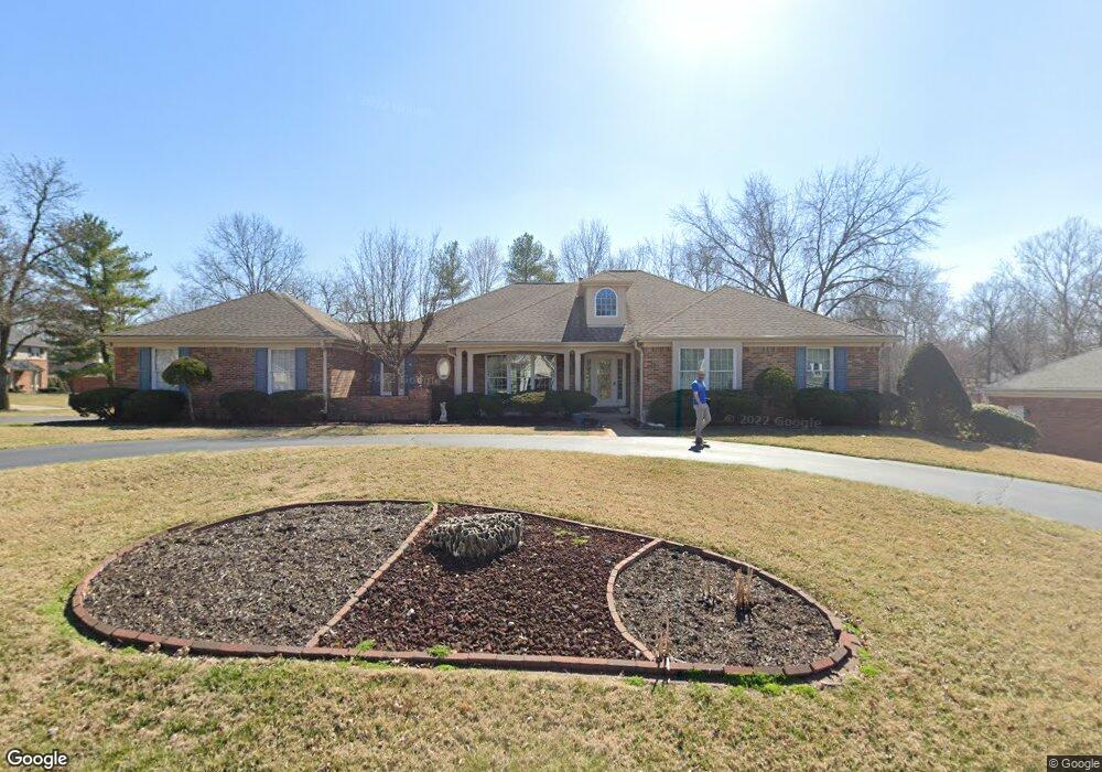
15902 Wetherburn Rd Chesterfield, MO 63017
Estimated Value: $536,000 - $771,000
4
Beds
4
Baths
2,490
Sq Ft
$275/Sq Ft
Est. Value
About This Home
This home is located at 15902 Wetherburn Rd, Chesterfield, MO 63017 and is currently estimated at $685,028, approximately $275 per square foot. 15902 Wetherburn Rd is a home located in St. Louis County with nearby schools including Kehrs Mill Elementary, Crestview Middle School, and Marquette Sr. High School.
Ownership History
Date
Name
Owned For
Owner Type
Purchase Details
Closed on
Aug 19, 2004
Sold by
Lorberg Raymond E and Lorberg Joan K
Bought by
Arneson Mark E and Arneson Kristin L
Current Estimated Value
Home Financials for this Owner
Home Financials are based on the most recent Mortgage that was taken out on this home.
Original Mortgage
$351,200
Outstanding Balance
$169,746
Interest Rate
5.62%
Mortgage Type
Purchase Money Mortgage
Estimated Equity
$515,282
Create a Home Valuation Report for This Property
The Home Valuation Report is an in-depth analysis detailing your home's value as well as a comparison with similar homes in the area
Home Values in the Area
Average Home Value in this Area
Purchase History
| Date | Buyer | Sale Price | Title Company |
|---|---|---|---|
| Arneson Mark E | $439,000 | Archway Title Agency Inc |
Source: Public Records
Mortgage History
| Date | Status | Borrower | Loan Amount |
|---|---|---|---|
| Open | Arneson Mark E | $351,200 |
Source: Public Records
Tax History
| Year | Tax Paid | Tax Assessment Tax Assessment Total Assessment is a certain percentage of the fair market value that is determined by local assessors to be the total taxable value of land and additions on the property. | Land | Improvement |
|---|---|---|---|---|
| 2025 | $7,934 | $125,850 | $42,860 | $82,990 |
| 2024 | $7,934 | $113,700 | $37,150 | $76,550 |
| 2023 | $7,928 | $113,700 | $37,150 | $76,550 |
| 2022 | $7,298 | $97,190 | $37,150 | $60,040 |
| 2021 | $7,245 | $97,190 | $37,150 | $60,040 |
| 2020 | $7,296 | $93,330 | $31,180 | $62,150 |
| 2019 | $7,326 | $93,330 | $31,180 | $62,150 |
| 2018 | $7,183 | $86,280 | $22,270 | $64,010 |
| 2016 | $6,421 | $75,960 | $22,270 | $53,690 |
Source: Public Records
Map
Nearby Homes
- 15911 Fairway Lake
- 2221 Stonegate Manor Ct
- 2352 the Courts Dr
- 2364 the Courts Dr
- 568 Trevi Ln
- 2316 Coventry Farm Ct
- 1050 Kehrs Mill Rd
- 927 Claytonbrook Dr Unit 3
- 1026 Kehrs Mill Rd Unit 4
- 916 Claytonbrook Dr Unit 1
- 922 Claytonbrook Dr Unit 1
- 538 Triton Way Dr
- 1019 Claytonbrook Dr Unit 1019
- 502 Trevi Ln
- 30 Meadowbrook Country Club Estate
- 2698 Joyceridge Dr
- 27 Meadowbrook Country Club Estate
- 78 Meadowbrook Country Club Estate
- 16025 Hunters Way Dr
- 2133 Hunters Way Ct
- 15908 Wetherburn Rd
- 2411 Capitol Landing Dr
- 15917 Chowning Ct
- 2404 Capitol Landing Dr
- 15901 Wetherburn Rd
- 2398 Capitol Landing Dr
- 15916 Wetherburn Rd
- 15907 Wetherburn Rd
- 2412 Capitol Landing Dr
- 2390 Capitol Landing Dr
- 15915 Wetherburn Rd
- 15925 Chowning Ct
- 2420 Capitol Landing Dr
- 2429 Capitol Landing Dr
- 655 Golfview Dr
- 663 Golfview Dr
- 2375 Westpar Dr
- 15921 Wetherburn Rd
- 647 Golfview Dr
- 671 Golfview Dr
Your Personal Tour Guide
Ask me questions while you tour the home.