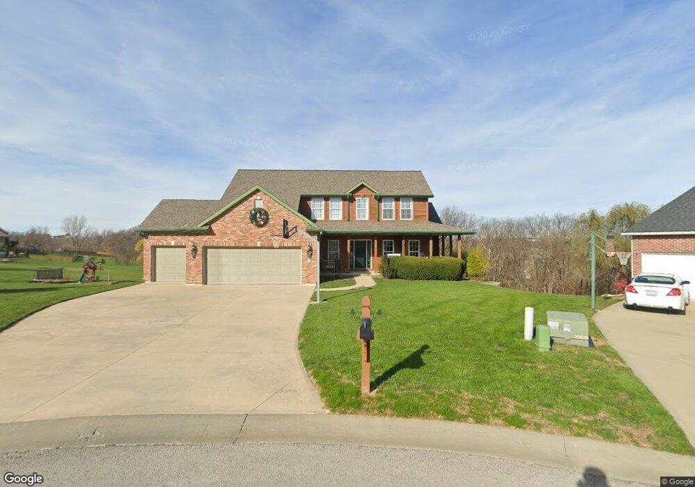
15940 NW 131st Ct Platte City, MO 64079
Estimated Value: $513,754 - $604,000
4
Beds
4
Baths
2,892
Sq Ft
$191/Sq Ft
Est. Value
About This Home
This home is located at 15940 NW 131st Ct, Platte City, MO 64079 and is currently estimated at $553,689, approximately $191 per square foot. 15940 NW 131st Ct is a home located in Platte County with nearby schools including Platte County High School.
Ownership History
Date
Name
Owned For
Owner Type
Purchase Details
Closed on
Jun 13, 2011
Sold by
Bowlin Robert A and Bowlin Grace K
Bought by
Bowlin Robert A and Bowlin Grace K
Current Estimated Value
Home Financials for this Owner
Home Financials are based on the most recent Mortgage that was taken out on this home.
Original Mortgage
$100,000
Outstanding Balance
$69,293
Interest Rate
4.74%
Mortgage Type
New Conventional
Estimated Equity
$484,396
Create a Home Valuation Report for This Property
The Home Valuation Report is an in-depth analysis detailing your home's value as well as a comparison with similar homes in the area
Home Values in the Area
Average Home Value in this Area
Purchase History
| Date | Buyer | Sale Price | Title Company |
|---|---|---|---|
| Bowlin Robert A | -- | -- |
Source: Public Records
Mortgage History
| Date | Status | Borrower | Loan Amount |
|---|---|---|---|
| Open | Bowlin Robert A | $100,000 |
Source: Public Records
Tax History Compared to Growth
Tax History
| Year | Tax Paid | Tax Assessment Tax Assessment Total Assessment is a certain percentage of the fair market value that is determined by local assessors to be the total taxable value of land and additions on the property. | Land | Improvement |
|---|---|---|---|---|
| 2024 | $4,752 | $71,440 | $14,123 | $57,317 |
| 2023 | $4,752 | $71,440 | $14,123 | $57,317 |
| 2022 | $4,528 | $67,460 | $14,123 | $53,337 |
| 2021 | $4,540 | $67,460 | $14,123 | $53,337 |
| 2020 | $4,308 | $63,273 | $12,400 | $50,873 |
| 2019 | $4,308 | $63,273 | $12,400 | $50,873 |
| 2018 | $3,801 | $55,375 | $11,400 | $43,975 |
| 2017 | $3,782 | $55,375 | $11,400 | $43,975 |
| 2016 | $3,750 | $55,375 | $11,400 | $43,975 |
| 2015 | $3,749 | $55,375 | $11,400 | $43,975 |
| 2013 | $3,182 | $51,300 | $0 | $0 |
Source: Public Records
Map
Nearby Homes
- 13060 Woodridge St
- 13180 Woodridge St
- 13420 Timber Park Dr
- 13360 Ridgeview Dr
- 15440 NW 127th St
- 15565 NW 127th St
- 15870 NW 126th Terrace
- 13657 Oak Valley Dr
- 12530 NW Riley Ct
- 17120 NW 133rd St
- 26 Misty Springs Cir
- The York Plan at Seven Bridges
- The Wyndham V Plan at Seven Bridges
- The Wydnham II Plan at Seven Bridges
- The Timberland Reverse Plan at Seven Bridges
- The Timberland Expanded Plan at Seven Bridges
- The Landon Plan at Seven Bridges
- The Tatum Plan at Seven Bridges
- The Sierra V Plan at Seven Bridges
- The Mackenzie Expanded Plan at Seven Bridges
- 15950 NW 131st Ct
- 15930 NW 131st Ct
- 15935 NW 131st Ct
- 15960 NW 131st Ct
- 15945 NW 131st Ct
- 15955 NW 131st Ct
- 13115 Woodridge St
- 0 NW 131st Ct
- 15970 NW 131st Ct
- 15965 NW 131st Ct
- 13125 Woodridge
- 15975 NW 131st Ct
- 13135 Woodridge
- 13095 Woodridge St
- 13100 Woodridge St
- 13145 Woodridge
- 13110 Woodridge St
- 13120 Woodridge St
- 13085 Woodridge St
- 13130 Woodridge St