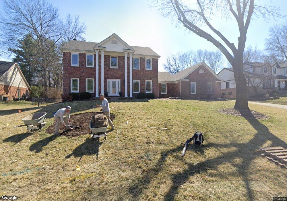
15952 Wetherburn Rd Chesterfield, MO 63017
Estimated Value: $685,745 - $753,000
4
Beds
5
Baths
2,830
Sq Ft
$252/Sq Ft
Est. Value
About This Home
This home is located at 15952 Wetherburn Rd, Chesterfield, MO 63017 and is currently estimated at $712,936, approximately $251 per square foot. 15952 Wetherburn Rd is a home located in St. Louis County with nearby schools including Kehrs Mill Elementary, Crestview Middle School, and Marquette Sr. High School.
Ownership History
Date
Name
Owned For
Owner Type
Purchase Details
Closed on
May 20, 2013
Sold by
Horowitz Lawrence and Horwitz Virginia L
Bought by
Bell Michael S and Bell Christina
Current Estimated Value
Home Financials for this Owner
Home Financials are based on the most recent Mortgage that was taken out on this home.
Original Mortgage
$280,800
Outstanding Balance
$198,350
Interest Rate
3.41%
Mortgage Type
New Conventional
Estimated Equity
$514,586
Create a Home Valuation Report for This Property
The Home Valuation Report is an in-depth analysis detailing your home's value as well as a comparison with similar homes in the area
Home Values in the Area
Average Home Value in this Area
Purchase History
| Date | Buyer | Sale Price | Title Company |
|---|---|---|---|
| Bell Michael S | $351,000 | Atc |
Source: Public Records
Mortgage History
| Date | Status | Borrower | Loan Amount |
|---|---|---|---|
| Open | Bell Michael S | $280,800 |
Source: Public Records
Tax History
| Year | Tax Paid | Tax Assessment Tax Assessment Total Assessment is a certain percentage of the fair market value that is determined by local assessors to be the total taxable value of land and additions on the property. | Land | Improvement |
|---|---|---|---|---|
| 2025 | $7,515 | $117,250 | $41,630 | $75,620 |
| 2024 | $7,515 | $107,670 | $36,060 | $71,610 |
| 2023 | $7,509 | $107,670 | $36,060 | $71,610 |
| 2022 | $7,133 | $94,980 | $36,060 | $58,920 |
| 2021 | $7,081 | $94,980 | $36,060 | $58,920 |
| 2020 | $7,004 | $89,570 | $29,930 | $59,640 |
| 2019 | $7,032 | $89,570 | $29,930 | $59,640 |
| 2018 | $6,507 | $78,130 | $21,380 | $56,750 |
| 2017 | $6,352 | $78,130 | $21,380 | $56,750 |
| 2016 | $6,083 | $71,940 | $21,380 | $50,560 |
Source: Public Records
Map
Nearby Homes
- 15911 Fairway Lake
- 2221 Stonegate Manor Ct
- 568 Trevi Ln
- 231 Pennington Ln
- 2352 the Courts Dr
- 2364 the Courts Dr
- 538 Triton Way Dr
- 502 Trevi Ln
- 2316 Coventry Farm Ct
- 1050 Kehrs Mill Rd
- 927 Claytonbrook Dr Unit 3
- 1026 Kehrs Mill Rd Unit 4
- 916 Claytonbrook Dr Unit 1
- 922 Claytonbrook Dr Unit 1
- 1019 Claytonbrook Dr Unit 1019
- 2698 Joyceridge Dr
- 30 Meadowbrook Country Club Estate
- 27 Meadowbrook Country Club Estate
- 1 Rendina Ct
- 208 Corral Trail
- 15960 Wetherburn Rd
- 15944 Wetherburn Rd
- 15953 Wetherburn Rd
- 15966 Wetherburn Rd
- 15936 Wetherburn Rd
- 15959 Trowbridge Rd
- 15975 Trowbridge Rd
- 15945 Wetherburn Rd
- 15967 Wetherburn Rd
- 15939 Wetherburn Rd
- 15972 Wetherburn Rd
- 15961 Downall Green Dr
- 15983 Trowbridge Rd
- 15951 Trowbridge Rd
- 15933 Wetherburn Rd
- 15928 Wetherburn Rd
- 15973 Wetherburn Rd
- 15968 Downall Green Dr
- 15978 Wetherburn Rd
Your Personal Tour Guide
Ask me questions while you tour the home.