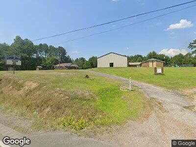
15981 Highway 269 Quinton, AL 35130
Estimated Value: $121,000 - $193,305
--
Bed
1
Bath
1,952
Sq Ft
$81/Sq Ft
Est. Value
About This Home
This home is located at 15981 Highway 269, Quinton, AL 35130 and is currently estimated at $157,153, approximately $80 per square foot. 15981 Highway 269 is a home located in Walker County.
Ownership History
Date
Name
Owned For
Owner Type
Purchase Details
Closed on
May 10, 2024
Sold by
Strickland Gary R
Bought by
Kimbrell One K K
Current Estimated Value
Purchase Details
Closed on
Dec 5, 2022
Sold by
Hulsey J H J and Hulsey Judith A
Bought by
Capps Dalton Michael
Home Financials for this Owner
Home Financials are based on the most recent Mortgage that was taken out on this home.
Original Mortgage
$184,000
Interest Rate
5.67%
Mortgage Type
Construction
Purchase Details
Closed on
Nov 21, 2019
Sold by
Sargent William Edward and Hulsey Judith Ann
Bought by
Sargent William Edward
Purchase Details
Closed on
Jul 15, 2014
Sold by
Sargent Willie Fay
Bought by
Sargent Willie Fay and Hulsey Judith Ann
Create a Home Valuation Report for This Property
The Home Valuation Report is an in-depth analysis detailing your home's value as well as a comparison with similar homes in the area
Home Values in the Area
Average Home Value in this Area
Purchase History
| Date | Buyer | Sale Price | Title Company |
|---|---|---|---|
| Kimbrell One K K | $193,000 | -- | |
| Capps Dalton Michael | $230,000 | -- | |
| Sargent William Edward | -- | None Available | |
| Sargent Willie Fay | -- | -- |
Source: Public Records
Mortgage History
| Date | Status | Borrower | Loan Amount |
|---|---|---|---|
| Previous Owner | Capps Dalton Michael | $184,000 |
Source: Public Records
Tax History Compared to Growth
Tax History
| Year | Tax Paid | Tax Assessment Tax Assessment Total Assessment is a certain percentage of the fair market value that is determined by local assessors to be the total taxable value of land and additions on the property. | Land | Improvement |
|---|---|---|---|---|
| 2024 | $20 | $6,480 | $6,480 | $0 |
| 2023 | $20 | $1,200 | $1,200 | $0 |
| 2022 | $482 | $40,860 | $26,810 | $14,050 |
| 2021 | $455 | $39,900 | $26,810 | $13,090 |
| 2020 | $435 | $18,460 | $5,360 | $13,100 |
| 2019 | $434 | $18,400 | $5,300 | $13,100 |
| 2018 | $0 | $17,420 | $5,220 | $12,200 |
| 2017 | $28 | $18,740 | $6,540 | $12,200 |
| 2016 | $28 | $18,680 | $6,480 | $12,200 |
| 2015 | $28 | $18,620 | $6,420 | $12,200 |
| 2014 | $26 | $32,660 | $20,680 | $11,980 |
| 2013 | $424 | $32,660 | $20,680 | $11,980 |
Source: Public Records
Map
Nearby Homes
- 0 Hidden Hollow Rd
- 0 Hatfield Trail Unit 24-1146
- 0 Hatfield Trail Unit 24-1144
- 0 Willow Fork Rd
- 515 River Dr
- 0 Pine Ln
- 2661 Underwood Ferry Rd
- LOT 15 River Crest Ranch
- 0 River Front Dr
- 304 Tuggle Rd
- Lot 1-A River Crest Dr Unit A
- 00 Granny Hyche Rd
- 1139 Pumpkin Center Cut Off Rd
- 208 Boat Launch Rd
- 0 Franklin Bend Rd Unit 24-1931
- 0 Reed Rd
- 0 Deer Dr Unit 64 21407801
- 0 Eagle Port Rd
- 1300 Pridmore Rd
- 1300 Pridemore Rd
