
Seller's Agent in 2025
Kathleen Duffy
William Raveis R.E. & Home Services
(617) 512-2336
29 in this area
74 Total Sales


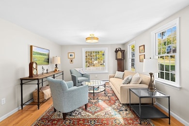

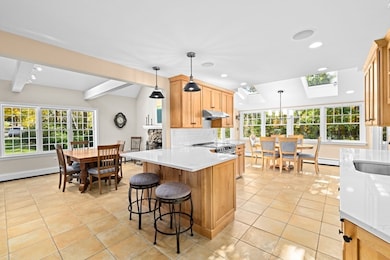


Experience timeless sophistication in this stunning home, ideally located in a sought-after cul-de-sac neighborhood with sidewalks to Minot Beach, North Scituate Village, and the commuter rail to Boston. Inside, you’re welcomed by a cozy living room to the right and a formal dining room with beamed cathedral ceiling and impressive stone fireplace to the left. The custom eat-in kitchen opens seamlessly to a spacious, sunlit family room also with cathedral ceiling and wood stove. All offering tranquil views of manicured grounds and surrounding marshland. The first floor also features a comfortable guest room and full bath. Upstairs, unwind in the elegant primary suite with Romeo balcony and private bath, along with two additional bedrooms and a third full bath. Additional features include a finished lower-level office, screened porch, deck, two-car garage, A/C, and generator. Minutes to area beaches, Hatherly Country Club, Scituate Harbor’s shops, restaurants, and marinas.
Last Agent to Sell the Property
William Raveis R.E. & Home Services Listed on: 10/23/2025
| Date | Type | Sale Price | Title Company |
|---|---|---|---|
| Quit Claim Deed | $1,315,000 | -- | |
| Quit Claim Deed | -- | None Available | |
| Quit Claim Deed | -- | None Available | |
| Deed | -- | -- | |
| Deed | -- | -- |
| Date | Status | Loan Amount | Loan Type |
|---|---|---|---|
| Previous Owner | $285,000 | No Value Available |
| Date | Event | Price | List to Sale | Price per Sq Ft |
|---|---|---|---|---|
| 12/11/2025 12/11/25 | Sold | $1,315,000 | +5.2% | $487 / Sq Ft |
| 10/27/2025 10/27/25 | Pending | -- | -- | -- |
| 10/23/2025 10/23/25 | For Sale | $1,250,000 | -- | $463 / Sq Ft |
| Year | Tax Paid | Tax Assessment Tax Assessment Total Assessment is a certain percentage of the fair market value that is determined by local assessors to be the total taxable value of land and additions on the property. | Land | Improvement |
|---|---|---|---|---|
| 2025 | $9,450 | $945,900 | $438,000 | $507,900 |
| 2024 | $9,287 | $896,400 | $398,200 | $498,200 |
| 2023 | $8,943 | $805,300 | $362,000 | $443,300 |
| 2022 | $8,943 | $708,600 | $332,200 | $376,400 |
| 2021 | $8,570 | $642,900 | $331,500 | $311,400 |
| 2020 | $7,983 | $591,300 | $318,700 | $272,600 |
| 2019 | $7,872 | $572,900 | $312,400 | $260,500 |
| 2018 | $7,494 | $537,200 | $305,200 | $232,000 |
| 2017 | $7,404 | $525,500 | $293,500 | $232,000 |
| 2016 | $7,098 | $502,000 | $270,000 | $232,000 |
| 2015 | $6,422 | $490,200 | $258,200 | $232,000 |
Seller's Agent in 2025
Kathleen Duffy
William Raveis R.E. & Home Services
(617) 512-2336
29 in this area
74 Total Sales
Buyer's Agent in 2025
Barbara Romanelli
Waterfront Realty Group
(781) 291-0078
1 in this area
21 Total Sales
Source: MLS Property Information Network (MLS PIN)
MLS Number: 73446921
APN: SCIT-000020-000004-000047K
Disclaimer: Certain information contained herein is derived from information provided by parties other than Homes.com. All information provided is deemed reliable, but is not guaranteed to be accurate and should be independently verified.
![]() The property listing data and information, or the Images, set forth herein were provided to MLS Property Information Network, Inc. from third party sources, including sellers, lessors and public records, and were compiled by MLS Property Information Network, Inc. The property listing data and information, and the Images, are for the personal, non-commercial use of consumers having a good faith interest in purchasing or leasing listed properties of the type displayed to them and may not be used for any purpose other than to identify prospective properties which such consumers may have a good faith interest in purchasing or leasing. MLS Property Information Network, Inc. and its subscribers disclaim any and all representations and warranties as to the accuracy of the property listing data and information, or as to the accuracy of any of the Images, set forth herein.
The property listing data and information, or the Images, set forth herein were provided to MLS Property Information Network, Inc. from third party sources, including sellers, lessors and public records, and were compiled by MLS Property Information Network, Inc. The property listing data and information, and the Images, are for the personal, non-commercial use of consumers having a good faith interest in purchasing or leasing listed properties of the type displayed to them and may not be used for any purpose other than to identify prospective properties which such consumers may have a good faith interest in purchasing or leasing. MLS Property Information Network, Inc. and its subscribers disclaim any and all representations and warranties as to the accuracy of the property listing data and information, or as to the accuracy of any of the Images, set forth herein.
Ask me questions while you tour the home.