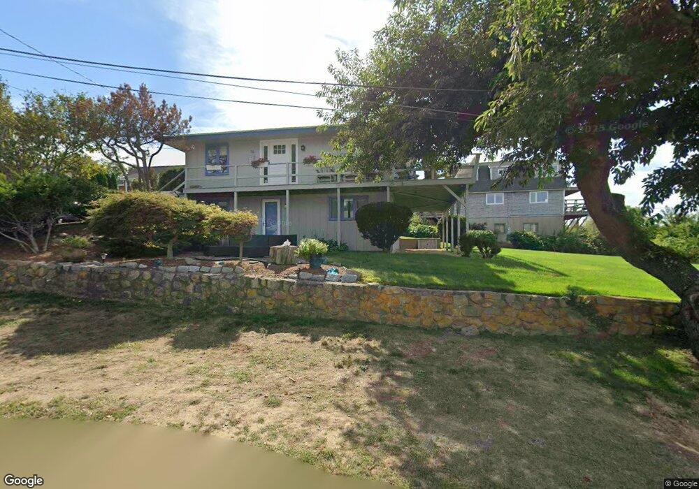
16 Norseman Ave Gloucester, MA 01930
Estimated Value: $1,008,662 - $1,310,000
3
Beds
2
Baths
900
Sq Ft
$1,258/Sq Ft
Est. Value
About This Home
This home is located at 16 Norseman Ave, Gloucester, MA 01930 and is currently estimated at $1,132,416, approximately $1,258 per square foot. 16 Norseman Ave is a home located in Essex County with nearby schools including Plum Cove School, Ralph B O'maley Middle School, and Gloucester High School.
Ownership History
Date
Name
Owned For
Owner Type
Purchase Details
Closed on
Jan 27, 2017
Sold by
Penn Deanna L
Bought by
Penn Deanna L and Collins Michael P
Current Estimated Value
Home Financials for this Owner
Home Financials are based on the most recent Mortgage that was taken out on this home.
Original Mortgage
$457,875
Outstanding Balance
$378,676
Interest Rate
4.16%
Mortgage Type
FHA
Estimated Equity
$753,740
Purchase Details
Closed on
Aug 25, 2008
Sold by
Penn Allan and Penn Deanna L
Bought by
Penn Deanna L
Home Financials for this Owner
Home Financials are based on the most recent Mortgage that was taken out on this home.
Original Mortgage
$83,945
Interest Rate
6.4%
Purchase Details
Closed on
Jan 24, 1997
Sold by
Sharoff Carole
Bought by
Penn Allan and Mcgovern Deanna L
Purchase Details
Closed on
Nov 25, 1996
Sold by
Krokyn William A and Krokyn Shirley A
Bought by
Sharoff Carole Lynn and Fonvielle William H
Create a Home Valuation Report for This Property
The Home Valuation Report is an in-depth analysis detailing your home's value as well as a comparison with similar homes in the area
Home Values in the Area
Average Home Value in this Area
Purchase History
| Date | Buyer | Sale Price | Title Company |
|---|---|---|---|
| Penn Deanna L | -- | -- | |
| Penn Deanna L | -- | -- | |
| Penn Allan | $243,000 | -- | |
| Sharoff Carole Lynn | $435,000 | -- |
Source: Public Records
Mortgage History
| Date | Status | Borrower | Loan Amount |
|---|---|---|---|
| Open | Penn Deanna L | $457,875 | |
| Previous Owner | Sharoff Carole Lynn | $417,000 | |
| Previous Owner | Sharoff Carole Lynn | $83,945 |
Source: Public Records
Tax History Compared to Growth
Tax History
| Year | Tax Paid | Tax Assessment Tax Assessment Total Assessment is a certain percentage of the fair market value that is determined by local assessors to be the total taxable value of land and additions on the property. | Land | Improvement |
|---|---|---|---|---|
| 2025 | $8,638 | $887,800 | $581,900 | $305,900 |
| 2024 | $8,638 | $887,800 | $581,900 | $305,900 |
| 2023 | $8,554 | $807,700 | $519,600 | $288,100 |
| 2022 | $8,048 | $686,100 | $441,900 | $244,200 |
| 2021 | $8,019 | $644,600 | $401,600 | $243,000 |
| 2020 | $7,662 | $621,400 | $401,600 | $219,800 |
| 2019 | $7,708 | $607,400 | $401,600 | $205,800 |
| 2018 | $7,704 | $595,800 | $401,600 | $194,200 |
| 2017 | $7,499 | $568,500 | $382,500 | $186,000 |
| 2016 | $7,390 | $543,000 | $383,400 | $159,600 |
| 2015 | $7,348 | $538,300 | $383,400 | $154,900 |
Source: Public Records
Map
Nearby Homes
- 2 Norseman Ave
- 6 Mount Locust Place Unit 2
- 962 Washington St
- 25 Stockholm Ave
- 3 Colburn St
- 3 Colburn St Unit 2
- 3 Colburn St Unit 1
- 13 Phillips Ave
- 165 Granite St
- 73 Phillips Ave
- 2 Wharf Rd
- 26 Quarry Ridge Ln
- 2 Boulder Top
- 1 Doctors Run
- 13 Rowe Point
- 79 Dennison St
- 6 River Rd
- 63R Main St Unit 2
- 123 Main St Unit 2
- 672 Washington St
- 17 Wishart Rd
- 15 Wishart Rd
- 21 Norseman Ave Unit 1
- 12 Norseman Ave
- 19A Norseman Ave
- 19 Norseman Ave
- 19 Norseman Ave Unit 1
- 31 Norseman Ave
- 15 Norseman Ave
- 18 Wishart Rd
- 13 Norseman Ave
- 11 Wishart Rd
- 10 Norseman Ave
- 8 Wishart Rd
- 11 Norseman Ave
- 10 Nikolane Way
- 35 Norseman Ave
- 7 Nikolane Way
- 37 Norseman Ave
- 8 Norseman Ave