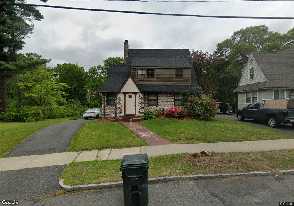
16 Northumberland St Springfield, MA 01109
Upper Hill NeighborhoodEstimated Value: $272,000 - $285,000
3
Beds
1
Bath
1,370
Sq Ft
$204/Sq Ft
Est. Value
About This Home
This home is located at 16 Northumberland St, Springfield, MA 01109 and is currently estimated at $279,527, approximately $204 per square foot. 16 Northumberland St is a home located in Hampden County with nearby schools including Homer Street Elementary School, John J Duggan Middle, and Springfield High School of Science and Technology.
Ownership History
Date
Name
Owned For
Owner Type
Purchase Details
Closed on
Oct 30, 1992
Sold by
Racicot Michael J and Racicot Penny B
Bought by
Maldonado Margie
Current Estimated Value
Home Financials for this Owner
Home Financials are based on the most recent Mortgage that was taken out on this home.
Original Mortgage
$81,885
Interest Rate
7.85%
Mortgage Type
Purchase Money Mortgage
Purchase Details
Closed on
Jul 7, 1987
Sold by
Est Irene M Wing
Bought by
Racicot Michael J
Home Financials for this Owner
Home Financials are based on the most recent Mortgage that was taken out on this home.
Original Mortgage
$133,000
Interest Rate
10.76%
Mortgage Type
Purchase Money Mortgage
Create a Home Valuation Report for This Property
The Home Valuation Report is an in-depth analysis detailing your home's value as well as a comparison with similar homes in the area
Home Values in the Area
Average Home Value in this Area
Purchase History
| Date | Buyer | Sale Price | Title Company |
|---|---|---|---|
| Maldonado Margie | $82,000 | -- | |
| Racicot Michael J | $95,900 | -- |
Source: Public Records
Mortgage History
| Date | Status | Borrower | Loan Amount |
|---|---|---|---|
| Closed | Racicot Michael J | $81,885 | |
| Previous Owner | Racicot Michael J | $133,000 |
Source: Public Records
Tax History Compared to Growth
Tax History
| Year | Tax Paid | Tax Assessment Tax Assessment Total Assessment is a certain percentage of the fair market value that is determined by local assessors to be the total taxable value of land and additions on the property. | Land | Improvement |
|---|---|---|---|---|
| 2025 | $3,760 | $239,800 | $41,100 | $198,700 |
| 2024 | $3,866 | $240,700 | $34,300 | $206,400 |
| 2023 | $3,424 | $200,800 | $31,200 | $169,600 |
| 2022 | $3,341 | $177,500 | $29,100 | $148,400 |
| 2021 | $3,134 | $165,800 | $26,500 | $139,300 |
| 2020 | $3,064 | $156,900 | $26,500 | $130,400 |
| 2019 | $3,043 | $154,600 | $26,500 | $128,100 |
| 2018 | $2,643 | $134,300 | $26,500 | $107,800 |
| 2017 | $2,548 | $129,600 | $24,500 | $105,100 |
| 2016 | $2,298 | $116,900 | $24,500 | $92,400 |
| 2015 | $2,229 | $113,300 | $15,300 | $98,000 |
Source: Public Records
Map
Nearby Homes
- 158 Norfolk St
- 867 Roosevelt Ave
- 75 Carnavon Cir
- 135-137 Suffolk St
- 0 NS (24) Alden St
- 111 Marlborough St
- 124-126 Westford Cir
- 67 Carlisle St
- 62-64 Bristol St
- 236 Pondview Dr
- 67 Villa Pkwy
- 21 Westford Cir
- 283 Wilbraham Rd
- 74 Judith St
- 23 Mary St
- 48-50 Dresden St
- 140 Northampton Ave
- 19 Westford Ave
- 97 Lancaster St
- 54 S Shore Dr
- 20 Northumberland St
- 5 Northumberland St
- 15 Northumberland St
- 23 Northumberland St
- 36 Northumberland St
- 550 Alden St
- 29 Northumberland St
- 229 Norfolk St
- 225 Norfolk St
- 235 Norfolk St
- 40 Northumberland St
- 241 Norfolk St
- 221 Norfolk St
- 11 Carnavon Cir
- 215 Norfolk St
- 245 Norfolk St
- 209 Norfolk St
- 251 Norfolk St
- 10 Carnavon Cir
- 255 Norfolk St