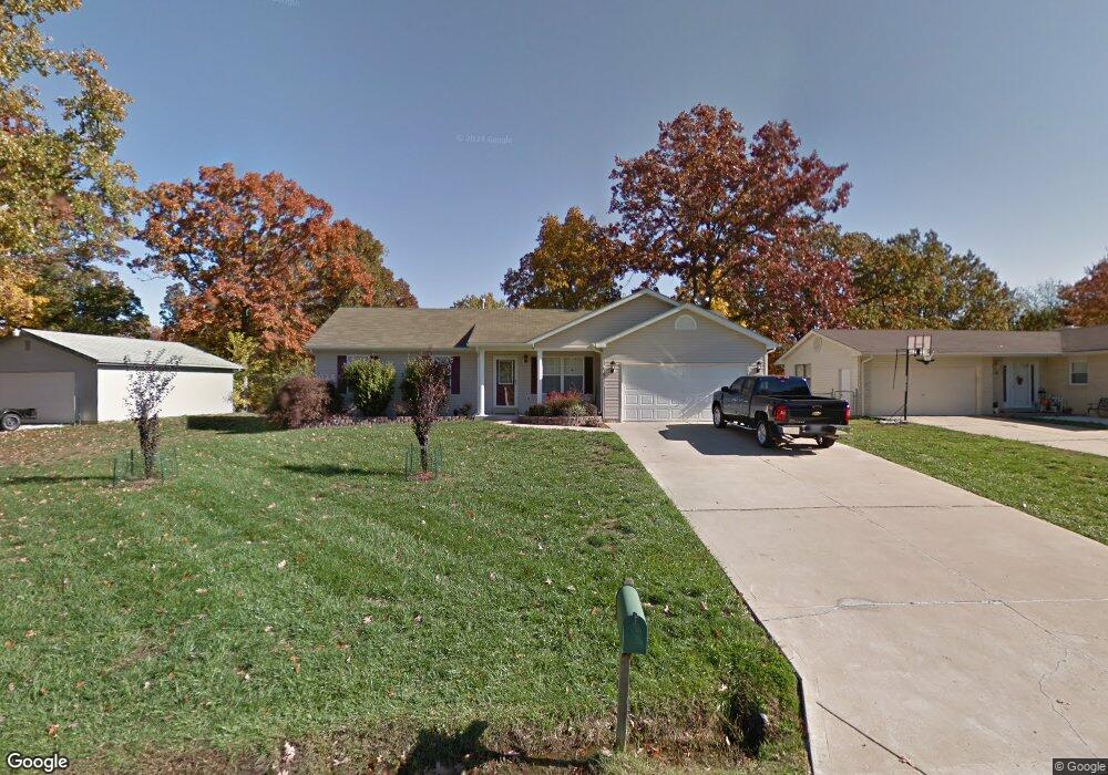
16 Pershing Cir O Fallon, MO 63366
Estimated Value: $295,946 - $338,000
3
Beds
2
Baths
1,435
Sq Ft
$223/Sq Ft
Est. Value
About This Home
This home is located at 16 Pershing Cir, O Fallon, MO 63366 and is currently estimated at $320,487, approximately $223 per square foot. 16 Pershing Cir is a home located in St. Charles County with nearby schools including Green Tree Elementary School, Wentzville South Middle School, and Timberland High School.
Ownership History
Date
Name
Owned For
Owner Type
Purchase Details
Closed on
Sep 19, 2024
Sold by
Fox Paula M
Bought by
Paula Fox Living Trust and Fox
Current Estimated Value
Purchase Details
Closed on
Jun 23, 2016
Sold by
Thompson Carrie A and Thompson Jeffrey W
Bought by
Fox Roland J and Fox Paula M
Home Financials for this Owner
Home Financials are based on the most recent Mortgage that was taken out on this home.
Original Mortgage
$147,920
Interest Rate
3.64%
Mortgage Type
New Conventional
Purchase Details
Closed on
Jan 16, 2009
Sold by
Thompson Carrie A and Thompson Jeffrey W
Bought by
Thompson Carrie A and Thompson Jeffrey W
Home Financials for this Owner
Home Financials are based on the most recent Mortgage that was taken out on this home.
Original Mortgage
$117,370
Interest Rate
5.42%
Mortgage Type
New Conventional
Purchase Details
Closed on
May 26, 2004
Sold by
Bias Douglas L and Bias Carrie A
Bought by
Bias Carrie A
Home Financials for this Owner
Home Financials are based on the most recent Mortgage that was taken out on this home.
Original Mortgage
$117,300
Interest Rate
4%
Mortgage Type
New Conventional
Purchase Details
Closed on
Apr 30, 2001
Sold by
Blomberg Christopher C and Blomberg Lisa K
Bought by
Bias Douglas L and Bias Carrie A
Home Financials for this Owner
Home Financials are based on the most recent Mortgage that was taken out on this home.
Original Mortgage
$120,605
Interest Rate
6.81%
Create a Home Valuation Report for This Property
The Home Valuation Report is an in-depth analysis detailing your home's value as well as a comparison with similar homes in the area
Home Values in the Area
Average Home Value in this Area
Purchase History
| Date | Buyer | Sale Price | Title Company |
|---|---|---|---|
| Paula Fox Living Trust | -- | None Listed On Document | |
| Fox Roland J | -- | Ust | |
| Thompson Carrie A | -- | Inv | |
| Bias Carrie A | -- | -- | |
| Bias Douglas L | -- | -- |
Source: Public Records
Mortgage History
| Date | Status | Borrower | Loan Amount |
|---|---|---|---|
| Previous Owner | Fox Roland J | $147,920 | |
| Previous Owner | Thompson Carrie A | $117,370 | |
| Previous Owner | Bias Carrie A | $117,300 | |
| Previous Owner | Bias Douglas L | $120,605 | |
| Closed | Bias Carrie A | $15,000 |
Source: Public Records
Tax History
| Year | Tax Paid | Tax Assessment Tax Assessment Total Assessment is a certain percentage of the fair market value that is determined by local assessors to be the total taxable value of land and additions on the property. | Land | Improvement |
|---|---|---|---|---|
| 2025 | $3,210 | $55,200 | -- | -- |
| 2023 | $3,209 | $48,786 | $0 | $0 |
| 2022 | $2,804 | $39,621 | $0 | $0 |
| 2021 | $2,801 | $39,621 | $0 | $0 |
| 2020 | $2,717 | $37,474 | $0 | $0 |
| 2019 | $2,522 | $37,474 | $0 | $0 |
| 2018 | $2,084 | $29,427 | $0 | $0 |
| 2017 | $2,074 | $29,427 | $0 | $0 |
| 2016 | $1,854 | $26,106 | $0 | $0 |
| 2015 | $1,822 | $26,106 | $0 | $0 |
| 2014 | $1,762 | $25,847 | $0 | $0 |
Source: Public Records
Map
Nearby Homes
- 7 King Cir
- 2 Royal Dr
- 1012 Delmar Dr
- 263 Tyndale Dr
- 703 Norwood Terrace
- 856 Brookmead Dr
- 1382 Apple Valley Dr
- 680 Lakewood Dr
- 655 Lakewood Dr
- 617 Lakeview Rd
- 903 Palmer Ct Unit 3
- 22 Holloway Dr
- 1373 Sunburst Dr
- 1011 Fairways Dr
- 1015 Fairways Dr
- 219 Place
- 410 Charlemagne Dr
- 136 Columbia Meadows Ln
- 1 Grand Columbia @ Columbia Meadows
- 1 Columbia @ Columbia Meadows
Your Personal Tour Guide
Ask me questions while you tour the home.