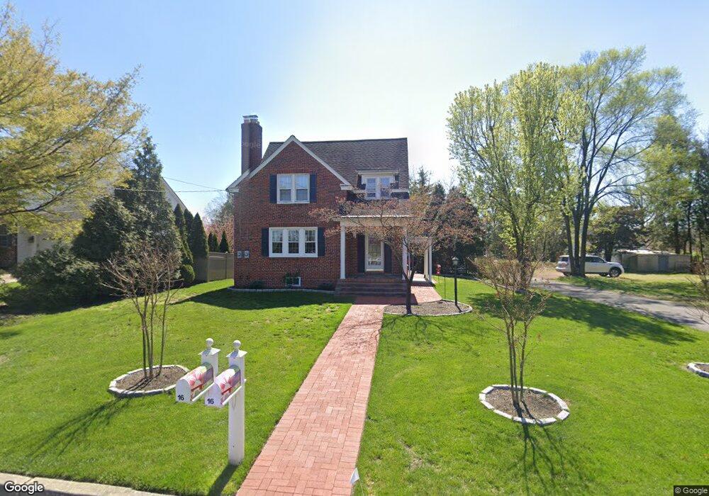
16 S Fork Landing Rd Cinnaminson, NJ 08077
Estimated Value: $409,000 - $525,000
4
Beds
2
Baths
1,402
Sq Ft
$317/Sq Ft
Est. Value
About This Home
This home is located at 16 S Fork Landing Rd, Cinnaminson, NJ 08077 and is currently estimated at $443,855, approximately $316 per square foot. 16 S Fork Landing Rd is a home located in Burlington County with nearby schools including New Albany Elementary School, Eleanor Rush Intermediate School, and Cinnaminson Middle School.
Ownership History
Date
Name
Owned For
Owner Type
Purchase Details
Closed on
Jan 27, 2021
Sold by
Davis John O and Davis Wayne A
Bought by
Davis Wayne Clifford
Current Estimated Value
Purchase Details
Closed on
Aug 6, 2013
Sold by
Davis Wayne A and Davis Barbara A
Bought by
Davis Wayne A
Purchase Details
Closed on
Aug 9, 2010
Sold by
Biondolillo David M
Bought by
Davis Wayne A and Davis Barbara A
Home Financials for this Owner
Home Financials are based on the most recent Mortgage that was taken out on this home.
Original Mortgage
$140,000
Interest Rate
4.63%
Mortgage Type
New Conventional
Purchase Details
Closed on
Aug 24, 2007
Sold by
Schoppe Todd W and Schoppe Renee L
Bought by
Biondolillo David M
Home Financials for this Owner
Home Financials are based on the most recent Mortgage that was taken out on this home.
Original Mortgage
$230,600
Interest Rate
6.71%
Mortgage Type
Purchase Money Mortgage
Purchase Details
Closed on
Jan 27, 2006
Sold by
Elliott William J and Elliott Charlene S
Bought by
Schoppe Todd W and Schoppe Renee L
Home Financials for this Owner
Home Financials are based on the most recent Mortgage that was taken out on this home.
Original Mortgage
$220,800
Interest Rate
6.17%
Mortgage Type
Stand Alone First
Purchase Details
Closed on
Nov 14, 1997
Sold by
Lindsey Michele Marie and Lindsey William Michael
Bought by
Lindsey Tomlinson Michele Marie and Lindsey William Michael
Home Financials for this Owner
Home Financials are based on the most recent Mortgage that was taken out on this home.
Original Mortgage
$60,000
Interest Rate
7.23%
Purchase Details
Closed on
Oct 29, 1997
Sold by
Winner Arthur C and Winner Linda A
Bought by
Elliott William J and Elliott Charlene S
Home Financials for this Owner
Home Financials are based on the most recent Mortgage that was taken out on this home.
Original Mortgage
$60,000
Interest Rate
7.23%
Create a Home Valuation Report for This Property
The Home Valuation Report is an in-depth analysis detailing your home's value as well as a comparison with similar homes in the area
Home Values in the Area
Average Home Value in this Area
Purchase History
| Date | Buyer | Sale Price | Title Company |
|---|---|---|---|
| Davis Wayne Clifford | -- | None Available | |
| Davis Wayne Clifford | -- | None Listed On Document | |
| Davis Wayne A | -- | None Available | |
| Davis Wayne A | $275,000 | Integrity Title Agency Inc | |
| Biondolillo David M | $288,250 | Commonwealth Land Title Insu | |
| Schoppe Todd W | $276,000 | Weichert Title Agency Inc | |
| Lindsey Tomlinson Michele Marie | -- | -- | |
| Elliott William J | $105,000 | Congress Title Corp |
Source: Public Records
Mortgage History
| Date | Status | Borrower | Loan Amount |
|---|---|---|---|
| Previous Owner | Davis Wayne A | $140,000 | |
| Previous Owner | Biondolillo David M | $230,600 | |
| Previous Owner | Schoppe Todd W | $220,800 | |
| Previous Owner | Elliott William J | $60,000 |
Source: Public Records
Tax History Compared to Growth
Tax History
| Year | Tax Paid | Tax Assessment Tax Assessment Total Assessment is a certain percentage of the fair market value that is determined by local assessors to be the total taxable value of land and additions on the property. | Land | Improvement |
|---|---|---|---|---|
| 2025 | $7,226 | $189,700 | $56,600 | $133,100 |
| 2024 | $7,051 | $189,700 | $56,600 | $133,100 |
| 2023 | $7,051 | $189,700 | $56,600 | $133,100 |
| 2022 | $6,897 | $189,700 | $56,600 | $133,100 |
| 2021 | $6,842 | $189,700 | $56,600 | $133,100 |
| 2020 | $6,776 | $189,700 | $56,600 | $133,100 |
| 2019 | $6,681 | $189,700 | $56,600 | $133,100 |
| 2018 | $6,634 | $189,700 | $56,600 | $133,100 |
| 2017 | $6,566 | $189,700 | $56,600 | $133,100 |
| 2016 | $6,474 | $189,700 | $56,600 | $133,100 |
| 2015 | $6,270 | $189,700 | $56,600 | $133,100 |
| 2014 | $5,970 | $189,700 | $56,600 | $133,100 |
Source: Public Records
Map
Nearby Homes
- 4 Smethwycke Dr
- 3 Glacier Dr
- 2414 Church Rd
- 21 Kohlmyer Dr
- Ballad Plan at Villages at Moorestown
- Cadence Plan at Villages at Moorestown
- Odessa Plan at Villages at Moorestown
- 1801 Madison St
- 83 Kohlmyer Dr
- 1119 Fernwood Ave
- 2308 Branch Pike
- 1631 Adams St
- 502 Pomona Rd
- 831 Windsor Dr
- 12 Collins Ln
- 4 W Germantown Ave
- 168 Fairfax Dr
- 3422 Palace Ct
- 43 E Henry St
- 432 N Coles Ave
- 18 Forklanding Rd
- 18 S Fork Landing Rd
- 14 S Fork Landing Rd
- 14 Forklanding Rd
- 2006 Berwick Dr
- 2 S Fork Landing Rd
- 1 Main St
- 12 Forklanding Rd
- 17 Forklanding Rd
- 12 S Fork Landing Rd
- 2004 Berwick Dr
- 4 Main St
- 2303 Lenola Rd
- 2 Main St
- 21 Forklanding Rd
- 2005 Berwick Dr
- 13 S Fork Landing Rd
- 7 S Fork Landing Rd
- 2002 Berwick Dr
- 2100 Berwick Dr