
Seller's Agent in 2025
Bria Durant
RE/MAX
(203) 228-0816
3 in this area
81 Total Sales
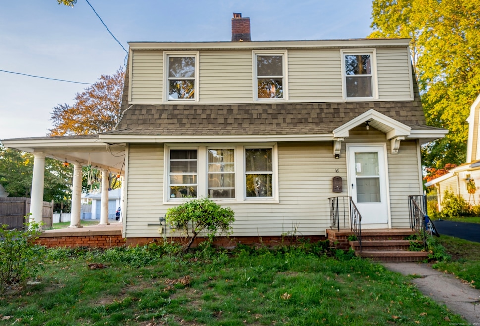
1920s Coastal Fixer with Endless Potential. Nestled in New Haven's beloved Lighthouse Point neighborhood, this classic 1920s home offers timeless character, water views, and the chance to create your dream coastal retreat. Just a few houses from the shoreline, and scenic Sound paths, 16 Shoreham Road blends vintage charm with solid fundamentals and a location that's second to none. Step inside to find hardwood floors throughout, a spacious living room with a wood-burning fireplace, and a lovely side porch framed by graceful pillars-perfect for morning coffee or golden-hour breezes. The formal dining room connects directly to the kitchen, ready for a stylish refresh that complements the home's original details. Upstairs, the front bedroom captures peaceful water views, offering a glimpse of what makes this area so sought after. The roof, vinyl siding, and mechanicals are approximately 10 years old, providing a strong foundation for future updates. Outside, enjoy a level backyard with room to grow-garden, patio, or potential expansion. Additional features include a full unfinished basement, gas heat, public water, and public sewer. Bring your vision and creativity to this rare Lighthouse Point opportunity-a home with great bones, a story to tell, and endless potential in one of New Haven's most desirable shoreline communities.
Last Agent to Sell the Property
RE/MAX Alliance Brokerage Phone: (203) 228-0816 License #RES.0796752 Listed on: 10/05/2025
Last Buyer's Agent
RE/MAX Alliance Brokerage Phone: (203) 228-0816 License #RES.0796752 Listed on: 10/05/2025
| Date | Type | Sale Price | Title Company |
|---|---|---|---|
| Warranty Deed | $304,000 | -- | |
| Quit Claim Deed | -- | -- | |
| Quit Claim Deed | -- | -- | |
| Warranty Deed | $47,500 | -- | |
| Warranty Deed | $47,500 | -- |
| Date | Status | Loan Amount | Loan Type |
|---|---|---|---|
| Open | $323,000 | New Conventional | |
| Previous Owner | $73,100 | No Value Available | |
| Previous Owner | $76,000 | Purchase Money Mortgage |
| Date | Event | Price | List to Sale | Price per Sq Ft |
|---|---|---|---|---|
| 11/03/2025 11/03/25 | Sold | $304,000 | +1.3% | $225 / Sq Ft |
| 10/06/2025 10/06/25 | For Sale | $300,000 | -1.3% | $222 / Sq Ft |
| 10/06/2025 10/06/25 | Off Market | $304,000 | -- | -- |
| 10/05/2025 10/05/25 | For Sale | $300,000 | -- | $222 / Sq Ft |
| Year | Tax Paid | Tax Assessment Tax Assessment Total Assessment is a certain percentage of the fair market value that is determined by local assessors to be the total taxable value of land and additions on the property. | Land | Improvement |
|---|---|---|---|---|
| 2025 | $6,487 | $164,640 | $69,020 | $95,620 |
| 2024 | $6,339 | $164,640 | $69,020 | $95,620 |
| 2023 | $6,125 | $164,640 | $69,020 | $95,620 |
| 2022 | $6,544 | $164,640 | $69,020 | $95,620 |
| 2021 | $5,452 | $124,250 | $48,930 | $75,320 |
| 2020 | $5,452 | $124,250 | $48,930 | $75,320 |
| 2019 | $5,340 | $124,250 | $48,930 | $75,320 |
| 2018 | $5,340 | $124,250 | $48,930 | $75,320 |
| 2017 | $4,806 | $124,250 | $48,930 | $75,320 |
| 2016 | $5,043 | $121,380 | $47,810 | $73,570 |
| 2015 | $5,043 | $121,380 | $47,810 | $73,570 |
| 2014 | $5,043 | $121,380 | $47,810 | $73,570 |
Seller's Agent in 2025
Bria Durant
RE/MAX
(203) 228-0816
3 in this area
81 Total Sales
Source: SmartMLS
MLS Number: 24131497
APN: NHVN-000031-000881-001200
Disclaimer: Certain information contained herein is derived from information provided by parties other than Homes.com. All information provided is deemed reliable, but is not guaranteed to be accurate and should be independently verified.
![]() IDX information is provided exclusively for personal, non-commercial use, and may not be used for any purpose other than to identify prospective properties consumers may be interested in purchasing. Information is deemed reliable but not guaranteed.
IDX information is provided exclusively for personal, non-commercial use, and may not be used for any purpose other than to identify prospective properties consumers may be interested in purchasing. Information is deemed reliable but not guaranteed.