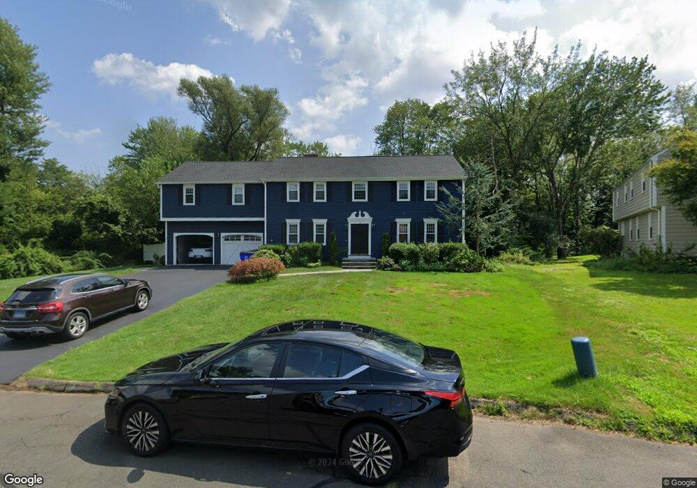
16 Stockade Cir Wethersfield, CT 06109
Estimated Value: $703,000 - $792,000
5
Beds
5
Baths
3,392
Sq Ft
$218/Sq Ft
Est. Value
About This Home
This home is located at 16 Stockade Cir, Wethersfield, CT 06109 and is currently estimated at $740,819, approximately $218 per square foot. 16 Stockade Cir is a home located in Hartford County with nearby schools including Highcrest School, Silas Deane Middle School, and Wethersfield High School.
Ownership History
Date
Name
Owned For
Owner Type
Purchase Details
Closed on
Jun 3, 2009
Sold by
Rogers Michael J and Rogers Mary-Ellen S
Bought by
Ursini Michael G and Ursini Michelle M
Current Estimated Value
Home Financials for this Owner
Home Financials are based on the most recent Mortgage that was taken out on this home.
Original Mortgage
$447,191
Interest Rate
4.83%
Create a Home Valuation Report for This Property
The Home Valuation Report is an in-depth analysis detailing your home's value as well as a comparison with similar homes in the area
Home Values in the Area
Average Home Value in this Area
Purchase History
| Date | Buyer | Sale Price | Title Company |
|---|---|---|---|
| Ursini Michael G | $484,500 | -- |
Source: Public Records
Mortgage History
| Date | Status | Borrower | Loan Amount |
|---|---|---|---|
| Open | Ursini Michael G | $438,277 | |
| Closed | Ursini Michael G | $438,277 | |
| Closed | Ursini Michael G | $447,191 |
Source: Public Records
Tax History
| Year | Tax Paid | Tax Assessment Tax Assessment Total Assessment is a certain percentage of the fair market value that is determined by local assessors to be the total taxable value of land and additions on the property. | Land | Improvement |
|---|---|---|---|---|
| 2025 | $17,216 | $417,660 | $111,760 | $305,900 |
| 2024 | $12,158 | $281,310 | $86,910 | $194,400 |
| 2023 | $11,753 | $281,310 | $86,910 | $194,400 |
| 2022 | $11,556 | $281,310 | $86,910 | $194,400 |
| 2021 | $11,441 | $281,310 | $86,910 | $194,400 |
| 2020 | $11,447 | $281,310 | $86,910 | $194,400 |
| 2019 | $11,461 | $281,310 | $86,910 | $194,400 |
| 2018 | $10,876 | $266,700 | $85,800 | $180,900 |
| 2017 | $10,607 | $266,700 | $85,800 | $180,900 |
| 2016 | $10,279 | $266,700 | $85,800 | $180,900 |
| 2015 | $10,185 | $266,700 | $85,800 | $180,900 |
| 2014 | $9,799 | $266,700 | $85,800 | $180,900 |
Source: Public Records
Map
Nearby Homes
- 268 Fox Hill Rd
- 155 Old Common Rd
- 25 Heather Hill
- 5 Robeth Ln
- 170 Whitewood Dr
- 101 Collier Rd
- 0 Collier Rd
- 5 Westmont Rd
- 18 Stone Hill Dr
- 6 Vinnie Dr
- 61 Luca Ln
- 76 Luca Lane Homesite 8
- 9 Dogwood Ct
- 312 Carlton Ln Unit 312
- 138 Cypress Rd Unit 138
- 92 Berkshire Rd
- 99 Elm Ridge Dr
- 72 Concord Dr
- 50 Concord Dr Unit 50
- 803 Holly Hill Dr Unit 803
Your Personal Tour Guide
Ask me questions while you tour the home.