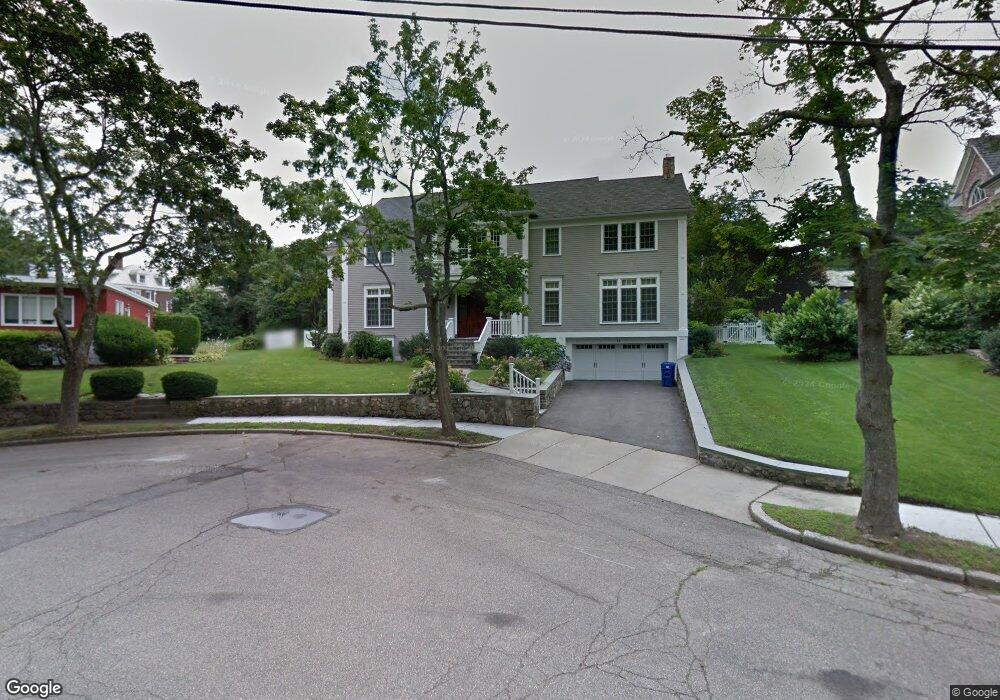
16 Treeland Cir Newton, MA 02458
Newton Corner NeighborhoodEstimated Value: $4,082,943 - $4,519,000
5
Beds
6
Baths
6,200
Sq Ft
$705/Sq Ft
Est. Value
About This Home
This home is located at 16 Treeland Cir, Newton, MA 02458 and is currently estimated at $4,371,648, approximately $705 per square foot. 16 Treeland Cir is a home located in Middlesex County with nearby schools including Ward Elementary School, Bigelow Middle School, and Newton North High School.
Ownership History
Date
Name
Owned For
Owner Type
Purchase Details
Closed on
Jun 20, 2012
Sold by
Benmayor Batya
Bought by
Natan Batya
Current Estimated Value
Purchase Details
Closed on
Sep 15, 2011
Sold by
Benmayor Albert
Bought by
Benmayor Batya
Purchase Details
Closed on
Nov 19, 2010
Sold by
Anka Corp
Bought by
Benmayor Albert and Benmayor Batya
Purchase Details
Closed on
Jun 11, 2007
Sold by
Treeland Rt and Kaplan Bryna
Bought by
Anka Corp
Purchase Details
Closed on
Sep 27, 2005
Sold by
Gertrude H Rubin Rt and Freeman Marjorie J
Bought by
Treeland Rt and Kaplan Bryna
Create a Home Valuation Report for This Property
The Home Valuation Report is an in-depth analysis detailing your home's value as well as a comparison with similar homes in the area
Home Values in the Area
Average Home Value in this Area
Purchase History
| Date | Buyer | Sale Price | Title Company |
|---|---|---|---|
| Natan Batya | -- | -- | |
| Benmayor Batya | -- | -- | |
| Benmayor Albert | $2,300,000 | -- | |
| Anka Corp | $2,460,000 | -- | |
| Treeland Rt | $775,000 | -- |
Source: Public Records
Tax History Compared to Growth
Tax History
| Year | Tax Paid | Tax Assessment Tax Assessment Total Assessment is a certain percentage of the fair market value that is determined by local assessors to be the total taxable value of land and additions on the property. | Land | Improvement |
|---|---|---|---|---|
| 2025 | $41,346 | $4,219,000 | $1,374,900 | $2,844,100 |
| 2024 | $39,978 | $4,096,100 | $1,334,900 | $2,761,200 |
| 2023 | $39,269 | $3,857,500 | $1,024,800 | $2,832,700 |
| 2022 | $37,575 | $3,571,800 | $948,900 | $2,622,900 |
| 2021 | $36,257 | $3,369,600 | $895,200 | $2,474,400 |
| 2020 | $35,179 | $3,369,600 | $895,200 | $2,474,400 |
| 2019 | $34,187 | $3,271,500 | $869,100 | $2,402,400 |
| 2018 | $33,470 | $3,093,300 | $788,500 | $2,304,800 |
| 2017 | $32,450 | $2,918,200 | $743,900 | $2,174,300 |
| 2016 | $31,037 | $2,727,300 | $695,200 | $2,032,100 |
| 2015 | $29,593 | $2,548,900 | $649,700 | $1,899,200 |
Source: Public Records
Map
Nearby Homes
- 59 Hyde Ave
- 35 George St Unit 35
- 37 George St Unit 37
- 686 Centre St
- 206 Franklin St
- 642 Centre St
- 106 Farlow Rd
- 548 Centre St Unit 5
- 5 Merrill Rd
- 23 Francis St Unit 23-1
- 21 Francis St Unit 21A
- 44 Irving St
- 68 Vernon St
- 14 Summit St
- 1004 Centre St
- 67 Algonquin Rd
- 21 Glenley Terrace
- 121 Tremont St Unit B1
- 12 Richardson St Unit 14
- 99 Tremont St Unit 105