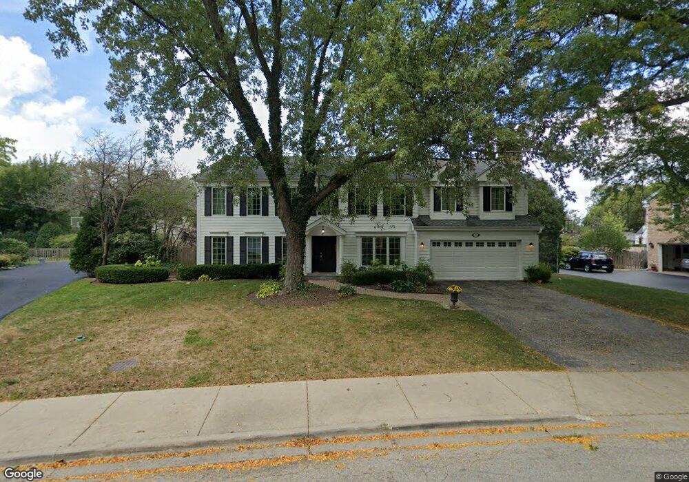
160 Millstone Rd Deerfield, IL 60015
Briarwood NeighborhoodEstimated Value: $810,000 - $1,203,000
Studio
3
Baths
3,743
Sq Ft
$282/Sq Ft
Est. Value
About This Home
This home is located at 160 Millstone Rd, Deerfield, IL 60015 and is currently estimated at $1,056,049, approximately $282 per square foot. 160 Millstone Rd is a home located in Lake County with nearby schools including Kipling Elementary School, Alan B Shepard Middle School, and Deerfield High School.
Ownership History
Date
Name
Owned For
Owner Type
Purchase Details
Closed on
Sep 18, 2023
Sold by
Cohen Jon D and Cohen Leslee M
Bought by
Jon D Cohen Living Trust and Leslee Moss Cohen Living Trust
Current Estimated Value
Purchase Details
Closed on
Sep 4, 1997
Sold by
Laner Steven R and Laner Judith L
Bought by
Segal Scott A
Home Financials for this Owner
Home Financials are based on the most recent Mortgage that was taken out on this home.
Original Mortgage
$332,000
Interest Rate
7.54%
Mortgage Type
Balloon
Create a Home Valuation Report for This Property
The Home Valuation Report is an in-depth analysis detailing your home's value as well as a comparison with similar homes in the area
Home Values in the Area
Average Home Value in this Area
Purchase History
| Date | Buyer | Sale Price | Title Company |
|---|---|---|---|
| Jon D Cohen Living Trust | -- | None Listed On Document | |
| Segal Scott A | $276,666 | Chicago Title Insurance Co |
Source: Public Records
Mortgage History
| Date | Status | Borrower | Loan Amount |
|---|---|---|---|
| Previous Owner | Segal Scott A | $332,000 |
Source: Public Records
Tax History
| Year | Tax Paid | Tax Assessment Tax Assessment Total Assessment is a certain percentage of the fair market value that is determined by local assessors to be the total taxable value of land and additions on the property. | Land | Improvement |
|---|---|---|---|---|
| 2024 | $22,843 | $274,208 | $73,412 | $200,796 |
| 2023 | $24,093 | $247,168 | $66,173 | $180,995 |
| 2022 | $24,093 | $255,981 | $72,694 | $183,287 |
| 2021 | $22,837 | $247,444 | $70,270 | $177,174 |
| 2020 | $21,904 | $247,444 | $70,270 | $177,174 |
| 2019 | $21,342 | $246,286 | $69,941 | $176,345 |
| 2018 | $21,437 | $257,833 | $77,630 | $180,203 |
| 2017 | $21,236 | $256,346 | $77,182 | $179,164 |
| 2016 | $20,448 | $244,046 | $73,479 | $170,567 |
| 2015 | $19,797 | $226,745 | $68,270 | $158,475 |
| 2014 | $16,270 | $208,111 | $82,065 | $126,046 |
| 2012 | $15,873 | $209,325 | $82,544 | $126,781 |
Source: Public Records
Map
Nearby Homes
- 971 Windsor Rd
- 990 Heather Rd
- 1177 Ridge Rd
- 707 Brierhill Rd
- 1236 Cavell Ave
- 520 Standish Dr
- 645 Ridge Rd
- 1334 Ferndale Ave
- 621 Ridge Rd
- 1039 Deerfield Place Unit 1039
- 1490 Avignon Ct
- 435 Kingston Terrace
- 326 Briar Ln
- 757 Kipling Place
- 1672 Huntington Ln
- 1127 Kenton Rd
- 453 Longfellow Ave
- 309 Ridge Rd
- 1300 Knollwood Rd
- 1202 Taylor Ave
- 150 Millstone Rd
- 170 Millstone Rd
- 890 Windsor Rd
- 155 Millstone Rd
- 140 Millstone Rd
- 107 Millstone Rd
- 846 Smoke Tree Rd
- 875 Piccadilly Rd
- 908 Windsor Rd
- 180 Millstone Rd
- 841 Fox Hunt Trail
- 926 Lilac Ln
- 887 Windsor Rd
- 895 Windsor Rd
- 126 Millstone Rd
- 930 Lilac Ln
- 855 Smoke Tree Rd
- 834 Smoke Tree Rd
- 936 Lilac Ln
- 918 Ring Ct
Your Personal Tour Guide
Ask me questions while you tour the home.