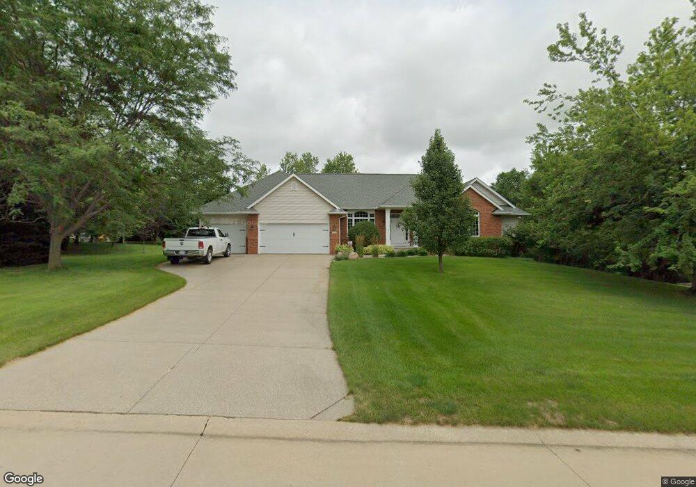
160 Morgan Ct Cedar Rapids, IA 52411
Estimated Value: $515,000 - $590,000
4
Beds
6
Baths
2,068
Sq Ft
$266/Sq Ft
Est. Value
About This Home
This home is located at 160 Morgan Ct, Cedar Rapids, IA 52411 and is currently estimated at $549,785, approximately $265 per square foot. 160 Morgan Ct is a home located in Linn County with nearby schools including Hiawatha Elementary School, Harding Middle School, and John F. Kennedy High School.
Ownership History
Date
Name
Owned For
Owner Type
Purchase Details
Closed on
Aug 31, 2021
Sold by
Ketchum James M and Ketchum Connie S
Bought by
Ketchum James M and James M Ketchum Revocable Trus
Current Estimated Value
Purchase Details
Closed on
Jan 4, 1999
Sold by
Pbi Properties
Bought by
Ketchum James M and Ketchum Connie S
Home Financials for this Owner
Home Financials are based on the most recent Mortgage that was taken out on this home.
Original Mortgage
$450,000
Outstanding Balance
$106,083
Interest Rate
6.95%
Estimated Equity
$443,702
Create a Home Valuation Report for This Property
The Home Valuation Report is an in-depth analysis detailing your home's value as well as a comparison with similar homes in the area
Home Values in the Area
Average Home Value in this Area
Purchase History
| Date | Buyer | Sale Price | Title Company |
|---|---|---|---|
| Ketchum James M | -- | None Available | |
| Ketchum James M | $449,500 | -- |
Source: Public Records
Mortgage History
| Date | Status | Borrower | Loan Amount |
|---|---|---|---|
| Open | Ketchum James M | $450,000 |
Source: Public Records
Tax History
| Year | Tax Paid | Tax Assessment Tax Assessment Total Assessment is a certain percentage of the fair market value that is determined by local assessors to be the total taxable value of land and additions on the property. | Land | Improvement |
|---|---|---|---|---|
| 2025 | $6,428 | $509,800 | $92,000 | $417,800 |
| 2024 | $6,060 | $493,800 | $92,000 | $401,800 |
| 2023 | $6,060 | $493,800 | $92,000 | $401,800 |
| 2022 | $6,450 | $406,500 | $92,000 | $314,500 |
| 2021 | $7,082 | $406,500 | $92,000 | $314,500 |
| 2020 | $7,082 | $413,500 | $92,000 | $321,500 |
| 2019 | $6,504 | $387,200 | $92,000 | $295,200 |
Source: Public Records
Map
Nearby Homes
- 1935 Kaylin Ct
- 1920 Kaylin Ct
- 1915 Kaylin Ct
- 1917 Kaylin Ct
- 1940 Kaylin Ct
- 1970 Kaylin Ct
- 1975 Kaylin Ct
- 39.69 Acres M/L N Center Point Rd
- 28.72 Acres M/L N Center Point Rd
- 8.98 Acres M/L N Center Point Rd
- 2850 Twinleaf Rd
- 380 Ascot Ln
- 0 28 72 Acres N Center Point Rd
- 3355 Wild Rose Rd
- 70.78 Acres M/L Quass Rd
- 26.35 Acres M/L Quass Rd
- 0 Rd
- 2457 Chloe Ln
- 2455 Chloe Ln
- 0 8 98 Acres M L N Center Point Rd Unit 2507297
- 1725 Mackenzie Dr
- 1615 Mackenzie Dr
- 1685 Mackenzie Dr
- 165 Morgan Ct
- 185 Morgan Ct
- 190 Morgan Ct
- 195 Morgan Ct
- 1700 Mackenzie Dr
- 1750 Mackenzie Dr
- 1660 Mackenzie Dr
- 1630 Mackenzie Dr
- 2937 N Center Point Rd
- 1800 Mackenzie Dr
- 1850 Mackenzie Dr
- 1600 Mackenzie Dr
- 1900 Mackenzie Dr
- 1550 Wicklow Dr
- 1565 Wicklow Dr
- 3318 Windhaven Ln
- 1500 Wicklow Dr
Your Personal Tour Guide
Ask me questions while you tour the home.