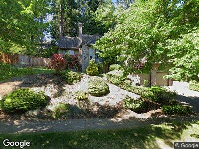
16066 SW Waxwing Way Beaverton, OR 97007
Neighbors Southwest NeighborhoodEstimated Value: $710,985 - $829,000
3
Beds
2
Baths
2,237
Sq Ft
$342/Sq Ft
Est. Value
About This Home
This home is located at 16066 SW Waxwing Way, Beaverton, OR 97007 and is currently estimated at $764,746, approximately $341 per square foot. 16066 SW Waxwing Way is a home located in Washington County with nearby schools including Nancy Ryles Elementary School, Highland Park Middle School, and Mountainside High School.
Ownership History
Date
Name
Owned For
Owner Type
Purchase Details
Closed on
May 25, 2016
Sold by
Tal Eliezer and Tal Bella
Bought by
Deskins Michael and Skiba Deskins Jennifer
Current Estimated Value
Home Financials for this Owner
Home Financials are based on the most recent Mortgage that was taken out on this home.
Original Mortgage
$334,000
Interest Rate
3.94%
Mortgage Type
New Conventional
Purchase Details
Closed on
Jul 20, 2010
Sold by
Dangremond Larry E and Dangremond Angie M
Bought by
Tal Eliezer and Tal Bella
Purchase Details
Closed on
Oct 4, 1999
Sold by
Walton Daniel A and Walton Linda L
Bought by
Dangremond Larry E and Dangremond Angie M
Home Financials for this Owner
Home Financials are based on the most recent Mortgage that was taken out on this home.
Original Mortgage
$199,100
Interest Rate
7.76%
Create a Home Valuation Report for This Property
The Home Valuation Report is an in-depth analysis detailing your home's value as well as a comparison with similar homes in the area
Home Values in the Area
Average Home Value in this Area
Purchase History
| Date | Buyer | Sale Price | Title Company |
|---|---|---|---|
| Deskins Michael | $479,000 | Ticor Title | |
| Tal Eliezer | $365,000 | First American | |
| Dangremond Larry E | $248,900 | Pacific Nw Title |
Source: Public Records
Mortgage History
| Date | Status | Borrower | Loan Amount |
|---|---|---|---|
| Open | Deskins Michael | $50,000 | |
| Previous Owner | Deskins Michael | $334,000 | |
| Previous Owner | Dangremond Larry E | $50,000 | |
| Previous Owner | Dangremond Larry E | $199,100 |
Source: Public Records
Tax History Compared to Growth
Tax History
| Year | Tax Paid | Tax Assessment Tax Assessment Total Assessment is a certain percentage of the fair market value that is determined by local assessors to be the total taxable value of land and additions on the property. | Land | Improvement |
|---|---|---|---|---|
| 2025 | $8,759 | $415,150 | -- | -- |
| 2024 | $8,270 | $403,060 | -- | -- |
| 2023 | $8,270 | $391,330 | $0 | $0 |
| 2022 | $7,915 | $391,330 | $0 | $0 |
| 2021 | $7,638 | $368,880 | $0 | $0 |
| 2020 | $7,406 | $358,140 | $0 | $0 |
| 2019 | $7,171 | $347,710 | $0 | $0 |
| 2018 | $6,943 | $337,590 | $0 | $0 |
| 2017 | $6,683 | $327,760 | $0 | $0 |
| 2016 | $6,451 | $318,220 | $0 | $0 |
| 2015 | $6,211 | $308,960 | $0 | $0 |
| 2014 | $6,079 | $299,970 | $0 | $0 |
Source: Public Records
Map
Nearby Homes
- 10915 SW Mourning Dove Place
- 10975 SW Avocet Ct
- 16235 SW Falcon Dr
- 11255 SW Chickadee Terrace
- 10215 SW Snowgoose Place
- 16790 SW Siler Ridge Ln
- 10420 SW 153rd Ave
- 15680 SW Talus Way
- 10415 SW 152nd Ave
- 15410 SW Bobwhite Cir
- 16555 SW Red Rock Ct
- 10553 SW Mount Adams Dr
- 9765 SW 163rd Ave
- 15900 SW Breccia Dr
- 9770 SW Tephra Terrace
- 16610 SW Sandstone Ct
- 15095 SW Weir Rd
- 9440 SW Diamond View Way
- 15160 SW Kingbird Dr
- 16465 SW Black Bird St
- 16066 SW Waxwing Way
- 16070 SW Waxwing Way
- 16060 SW Waxwing Way
- 10545 SW 161st Ct
- 10535 SW 161st Ct
- 10555 SW 161st Ct
- 16067 SW Waxwing Way
- 16076 SW Waxwing Way
- 16054 SW Waxwing Way
- 16071 SW Waxwing Way
- 16063 SW Waxwing Way
- 10565 SW 161st Ct
- 10525 SW 161st Ct
- 16059 SW Waxwing Way
- 16077 SW Waxwing Place
- 16082 SW Waxwing Way
- 16055 SW Waxwing Way
- 10550 SW 161st Murrayhill
- 10520 SW 161st Ct
- 10550 SW 161st Ct