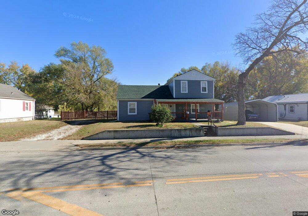
1609 10th Ave Leavenworth, KS 66048
Estimated Value: $212,000 - $291,000
3
Beds
3
Baths
1,431
Sq Ft
$176/Sq Ft
Est. Value
About This Home
This home is located at 1609 10th Ave, Leavenworth, KS 66048 and is currently estimated at $251,317, approximately $175 per square foot. 1609 10th Ave is a home located in Leavenworth County with nearby schools including Anthony Elementary School, Richard Warren Middle School, and Leavenworth Senior High School.
Ownership History
Date
Name
Owned For
Owner Type
Purchase Details
Closed on
May 6, 2019
Sold by
Shinaberry Douglas R
Bought by
Petrik James J
Current Estimated Value
Purchase Details
Closed on
Mar 28, 2008
Sold by
Scanlon Patrick M and Scanlon Susan V
Bought by
Owens Haza D
Home Financials for this Owner
Home Financials are based on the most recent Mortgage that was taken out on this home.
Original Mortgage
$92,795
Interest Rate
4.06%
Mortgage Type
FHA
Create a Home Valuation Report for This Property
The Home Valuation Report is an in-depth analysis detailing your home's value as well as a comparison with similar homes in the area
Home Values in the Area
Average Home Value in this Area
Purchase History
| Date | Buyer | Sale Price | Title Company |
|---|---|---|---|
| Petrik James J | -- | Stewart Title | |
| Owens Haza D | $93,722 | Mccaffree-Short Title Co Inc |
Source: Public Records
Mortgage History
| Date | Status | Borrower | Loan Amount |
|---|---|---|---|
| Previous Owner | Owens Haza D | $92,795 | |
| Closed | Owens Haza D | $92,795 |
Source: Public Records
Tax History Compared to Growth
Tax History
| Year | Tax Paid | Tax Assessment Tax Assessment Total Assessment is a certain percentage of the fair market value that is determined by local assessors to be the total taxable value of land and additions on the property. | Land | Improvement |
|---|---|---|---|---|
| 2025 | $2,477 | $22,371 | $1,317 | $21,054 |
| 2024 | $2,455 | $21,306 | $1,317 | $19,989 |
| 2023 | $2,455 | $20,486 | $1,317 | $19,169 |
| 2022 | $2,149 | $17,814 | $1,377 | $16,437 |
| 2021 | $1,865 | $14,421 | $1,377 | $13,044 |
| 2020 | $1,894 | $13,890 | $1,377 | $12,513 |
| 2019 | $1,776 | $12,849 | $1,377 | $11,472 |
| 2018 | $1,694 | $12,123 | $1,377 | $10,746 |
| 2017 | $1,483 | $11,446 | $1,377 | $10,069 |
| 2016 | $1,426 | $11,006 | $1,377 | $9,629 |
| 2015 | $1,355 | $10,531 | $1,831 | $8,700 |
| 2014 | $1,499 | $11,668 | $1,831 | $9,837 |
Source: Public Records
Map
Nearby Homes
- 1700 Lawrence Ave
- 1509 10th Ave
- 1715 Klemp St
- 1420 10th Ave
- 1708 S Broadway St
- 1932 S Broadway St
- 1305 Lawrence Ave
- 1305 Klemp St
- 1913 Cleveland Terrace
- 1116 Quincy St
- 708 Thornton St
- 1417 5th Ave
- 1004 Randolph St
- 1208 Quincy St
- 1011 9th Ave
- 1158 Randolph St
- 1203 5th Ave
- 927 Columbia Ave
- 1036 Vilas St
- 1166 Kenton St
- 1615 10th Ave
- 1605 10th Ave
- 905 Michigan Ave
- 905 Michigan Ave
- 918 Pennsylvania Ave
- 914 Pennsylvania Ave
- 1612 Lawrence Ave
- 1601 10th Ave
- 908 Pennsylvania Ave
- 904 Pennsylvania Ave
- 1606 10th Ave
- 28051 State Hwy 189
- 1614 10th Ave
- 902 Pennsylvania Ave
- 1600 10th Ave
- 1529 10th Ave
- 900 Pennsylvania St
- 1521 10th Ave
- 1609 Lawrence Ave
- 900 Michigan Ave