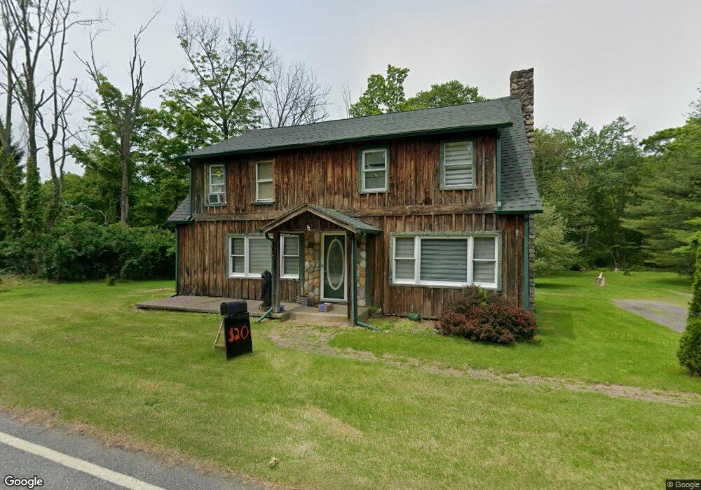
161 Mattison Reservoir Ave Branchville, NJ 07826
Estimated Value: $415,119 - $537,000
--
Bed
--
Bath
1,971
Sq Ft
$239/Sq Ft
Est. Value
About This Home
This home is located at 161 Mattison Reservoir Ave, Branchville, NJ 07826 and is currently estimated at $470,280, approximately $238 per square foot. 161 Mattison Reservoir Ave is a home located in Sussex County with nearby schools including Frankford Township School and High Point Regional High School.
Ownership History
Date
Name
Owned For
Owner Type
Purchase Details
Closed on
Sep 22, 1999
Sold by
Hud
Bought by
Mccurry Andrew and Mccurry Donna
Current Estimated Value
Home Financials for this Owner
Home Financials are based on the most recent Mortgage that was taken out on this home.
Original Mortgage
$68,400
Outstanding Balance
$20,714
Interest Rate
8.1%
Estimated Equity
$449,566
Purchase Details
Closed on
Nov 13, 1997
Sold by
Batson Donald W and Fetterman Gail E
Bought by
Hud
Purchase Details
Closed on
Nov 16, 1994
Sold by
Felton Carmen
Bought by
Batson Donald W and Fetterman Gail
Create a Home Valuation Report for This Property
The Home Valuation Report is an in-depth analysis detailing your home's value as well as a comparison with similar homes in the area
Home Values in the Area
Average Home Value in this Area
Purchase History
| Date | Buyer | Sale Price | Title Company |
|---|---|---|---|
| Mccurry Andrew | $76,000 | -- | |
| Hud | -- | -- | |
| Batson Donald W | $113,000 | -- |
Source: Public Records
Mortgage History
| Date | Status | Borrower | Loan Amount |
|---|---|---|---|
| Open | Mccurry Andrew | $68,400 |
Source: Public Records
Tax History Compared to Growth
Tax History
| Year | Tax Paid | Tax Assessment Tax Assessment Total Assessment is a certain percentage of the fair market value that is determined by local assessors to be the total taxable value of land and additions on the property. | Land | Improvement |
|---|---|---|---|---|
| 2025 | $6,677 | $224,500 | $100,000 | $124,500 |
| 2024 | $6,477 | $224,500 | $100,000 | $124,500 |
| 2023 | $6,477 | $224,500 | $100,000 | $124,500 |
| 2022 | $6,320 | $224,500 | $100,000 | $124,500 |
| 2021 | $6,129 | $224,500 | $100,000 | $124,500 |
| 2020 | $5,954 | $224,500 | $100,000 | $124,500 |
| 2019 | $5,785 | $224,500 | $100,000 | $124,500 |
| 2018 | $5,731 | $224,500 | $100,000 | $124,500 |
| 2017 | $5,711 | $224,500 | $100,000 | $124,500 |
| 2016 | $5,783 | $224,500 | $100,000 | $124,500 |
| 2015 | $5,754 | $224,500 | $100,000 | $124,500 |
| 2014 | $5,886 | $224,500 | $100,000 | $124,500 |
Source: Public Records
Map
Nearby Homes
- 99 Phillips Rd
- 127 E Shore Culver Rd
- 30 - 31 E Shore Culver Rd
- 216 Mattison Reservoir Ave
- 220 Mattison Reservoir Ave
- 64 Mattison Rd
- 78 E Shore Culver Rd
- 83 Hyatt Rd
- 461 U S Highway 206
- 7 Laurel Ave
- 13 U S 206
- 4 Lake Path 1
- 15 Forest St
- 6 Woodlawn Ave
- 4 Woodlawn Ave
- 1 Lakeview Point Ave
- 39 Stehr St
- 9 Maple Ln
- 27 Mountain Trail
- 9 Woods Rd
- 145 Upper North Shore Rd
- 139 Upper North Shore Rd
- 165 Mattison Reservoir Ave
- 164 Mattison Reservoir Ave
- 144 Upper North Shore Rd
- 167 Mattison Reservoir Ave
- 149 Upper North Shore Rd
- 166 Mattison Reservoir Ave
- 148 Upper North Shore Rd
- 168 Mattison Reservoir Ave
- 144 Mattison Rd
- 150 Upper Norouteh Shore Rd
- 171 Mattison Reservoir Ave
- 153 Upper North Shore Rd
- 134 Upper North Shore Rd
- 152 Upper North Shore Rd
- 157 Upper Norouteh Shore Rd
- 140 Mattison Rd
- 175 Mattison Reservoir Ave
- 174 Mattison Reservoir Ave