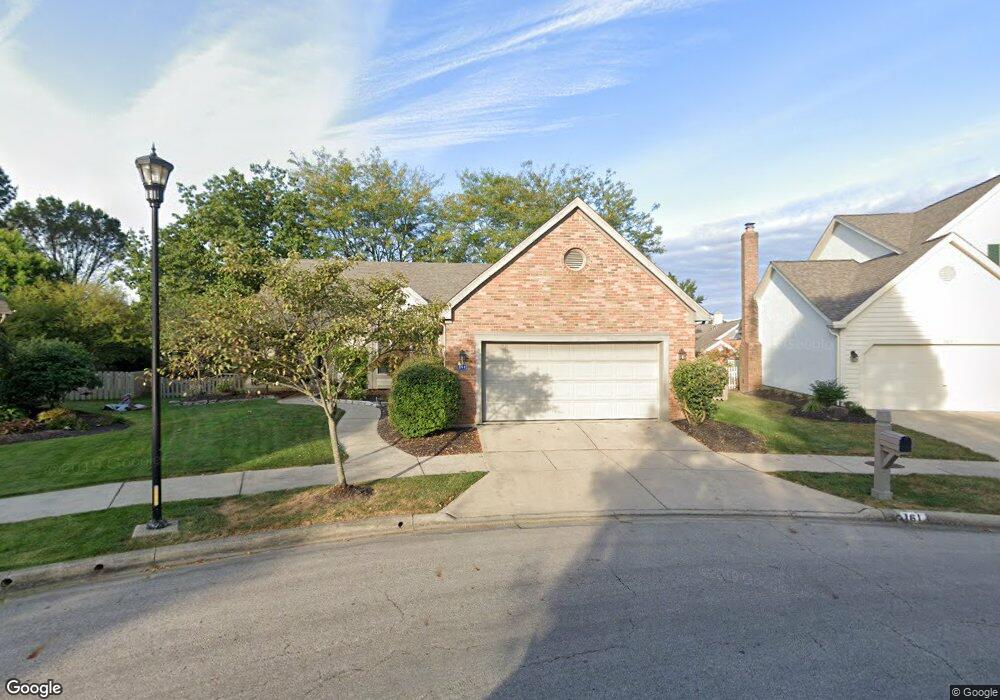
161 Sandstone Loop W Westerville, OH 43081
Estimated Value: $395,335 - $491,000
3
Beds
2
Baths
1,760
Sq Ft
$248/Sq Ft
Est. Value
About This Home
This home is located at 161 Sandstone Loop W, Westerville, OH 43081 and is currently estimated at $436,084, approximately $247 per square foot. 161 Sandstone Loop W is a home located in Franklin County with nearby schools including Mcvay Elementary School, Walnut Springs Middle School, and Westerville-North High School.
Ownership History
Date
Name
Owned For
Owner Type
Purchase Details
Closed on
Aug 30, 2010
Sold by
Keesee William S and Keesee Shirley M
Bought by
Shown Arthur D and Laubach Shown Judith
Current Estimated Value
Home Financials for this Owner
Home Financials are based on the most recent Mortgage that was taken out on this home.
Original Mortgage
$116,000
Outstanding Balance
$76,017
Interest Rate
4.6%
Mortgage Type
Purchase Money Mortgage
Estimated Equity
$360,067
Purchase Details
Closed on
Nov 6, 1996
Sold by
Woodard Charles E
Bought by
Keesee William S and Keesee Shirley M
Home Financials for this Owner
Home Financials are based on the most recent Mortgage that was taken out on this home.
Original Mortgage
$97,000
Interest Rate
5.75%
Mortgage Type
New Conventional
Purchase Details
Closed on
Oct 22, 1991
Create a Home Valuation Report for This Property
The Home Valuation Report is an in-depth analysis detailing your home's value as well as a comparison with similar homes in the area
Home Values in the Area
Average Home Value in this Area
Purchase History
| Date | Buyer | Sale Price | Title Company |
|---|---|---|---|
| Shown Arthur D | $216,000 | Focus Title | |
| Keesee William S | $190,000 | -- | |
| -- | $194,700 | -- |
Source: Public Records
Mortgage History
| Date | Status | Borrower | Loan Amount |
|---|---|---|---|
| Open | Shown Arthur D | $116,000 | |
| Previous Owner | Keesee William S | $97,000 |
Source: Public Records
Tax History
| Year | Tax Paid | Tax Assessment Tax Assessment Total Assessment is a certain percentage of the fair market value that is determined by local assessors to be the total taxable value of land and additions on the property. | Land | Improvement |
|---|---|---|---|---|
| 2025 | $6,169 | $118,340 | $29,400 | $88,940 |
| 2024 | $6,169 | $118,340 | $29,400 | $88,940 |
| 2023 | $6,073 | $118,335 | $29,400 | $88,935 |
| 2022 | $5,496 | $84,180 | $21,000 | $63,180 |
| 2021 | $5,542 | $84,180 | $21,000 | $63,180 |
| 2020 | $5,526 | $84,180 | $21,000 | $63,180 |
| 2019 | $4,729 | $69,690 | $17,500 | $52,190 |
| 2018 | $4,747 | $69,690 | $17,500 | $52,190 |
| 2017 | $4,833 | $69,690 | $17,500 | $52,190 |
| 2016 | $5,015 | $68,570 | $21,600 | $46,970 |
| 2015 | $4,858 | $68,570 | $21,600 | $46,970 |
| 2014 | $4,861 | $68,570 | $21,600 | $46,970 |
| 2013 | $2,427 | $68,565 | $21,595 | $46,970 |
Source: Public Records
Map
Nearby Homes
- 1151 Scarlet Ct
- 1114 Forest View Ct
- 961 E College Ave
- 613 Deer Run Rd
- 180 Oakwood Ct
- 655 Mohican Way
- 45 Kanpur Place
- 636 E Schrock Rd
- 612 E Schrock Rd
- 960 Lakeland Dr
- 138 Wood St
- 487 Beachside Dr
- 629 Andrew Ave
- 6553 Bowery Peak Ln
- 456 Saint Thomas Dr
- 291 Mohawk Ave
- 703 Pointview Dr
- 322 Huber Village Blvd
- 974 Timberbank Dr
- 4650 Cautela Dr
- 157 Sandstone Loop W
- 1321 Sandstone Loop S
- 151 Sandstone Loop W
- 1320 Sandstone Loop S
- 1323 Sandstone Loop S
- 1324 Sandstone Loop S
- 145 Sandstone Loop W
- 1327 Sandstone Loop S
- 1327 Cobblestone Ave
- 1328 Sandstone Loop S
- 1329 Cobblestone Ave
- 1331 Sandstone Loop S
- 1362 Sugarberry Ct
- 168 Shagbark Dr
- 160 Shagbark Dr
- 1331 Cobblestone Ave
- 1332 Sandstone Loop S
- 1368 Sugarberry Ct
- 1318 Cobblestone Ave
- 1312 Cobblestone Ave
Your Personal Tour Guide
Ask me questions while you tour the home.