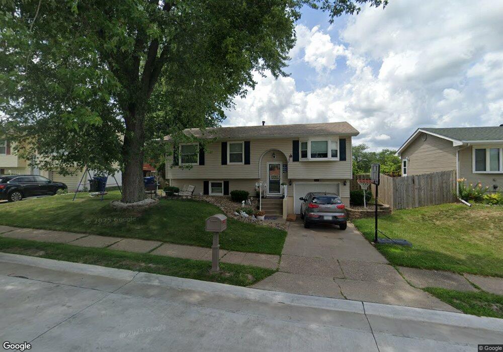
1610 N Stark St Davenport, IA 52804
Northwest Davenport NeighborhoodEstimated Value: $155,651 - $194,000
3
Beds
3
Baths
900
Sq Ft
$196/Sq Ft
Est. Value
About This Home
This home is located at 1610 N Stark St, Davenport, IA 52804 and is currently estimated at $176,413, approximately $196 per square foot. 1610 N Stark St is a home located in Scott County with nearby schools including Walnut Hill Elementary School, South Christian Elementary School, and Frank L. Smart Intermediate School.
Ownership History
Date
Name
Owned For
Owner Type
Purchase Details
Closed on
Sep 10, 2007
Sold by
Westlin Stephen T and Westlin Beth A
Bought by
Burke Leah L
Current Estimated Value
Home Financials for this Owner
Home Financials are based on the most recent Mortgage that was taken out on this home.
Original Mortgage
$122,900
Outstanding Balance
$78,051
Interest Rate
6.63%
Mortgage Type
New Conventional
Estimated Equity
$98,362
Create a Home Valuation Report for This Property
The Home Valuation Report is an in-depth analysis detailing your home's value as well as a comparison with similar homes in the area
Home Values in the Area
Average Home Value in this Area
Purchase History
| Date | Buyer | Sale Price | Title Company |
|---|---|---|---|
| Burke Leah L | $123,000 | None Available |
Source: Public Records
Mortgage History
| Date | Status | Borrower | Loan Amount |
|---|---|---|---|
| Open | Burke Leah L | $122,900 |
Source: Public Records
Tax History Compared to Growth
Tax History
| Year | Tax Paid | Tax Assessment Tax Assessment Total Assessment is a certain percentage of the fair market value that is determined by local assessors to be the total taxable value of land and additions on the property. | Land | Improvement |
|---|---|---|---|---|
| 2025 | $3,397 | $148,750 | $25,580 | $123,170 |
| 2024 | $3,461 | $148,750 | $25,580 | $123,170 |
| 2023 | $3,675 | $148,750 | $25,580 | $123,170 |
| 2022 | $3,545 | $129,240 | $21,740 | $107,500 |
| 2021 | $2,688 | $125,290 | $21,740 | $103,550 |
| 2020 | $3,327 | $123,320 | $21,740 | $101,580 |
| 2019 | $3,891 | $115,430 | $21,740 | $93,690 |
| 2018 | $2,216 | $115,430 | $21,740 | $93,690 |
| 2017 | $615 | $110,500 | $21,740 | $88,760 |
| 2016 | $3,142 | $105,570 | $0 | $0 |
| 2015 | $2,312 | $105,270 | $0 | $0 |
| 2014 | $2,338 | $105,270 | $0 | $0 |
| 2013 | $2,298 | $0 | $0 | $0 |
| 2012 | -- | $99,650 | $22,820 | $76,830 |
Source: Public Records
Map
Nearby Homes
- 1310 Calvin St
- 1215 Calvin St
- 1139 Calvin St
- 3920 W 13th St
- 1312 Emerald Dr
- 2025 Emerald Dr
- 0 W Locust St Unit Utah
- 0 W Locust St Unit 23235762
- 0 W Locust St Unit NOC6326699
- 4703 W 13th St
- 2218 Emerald Dr
- 1215 Waverly Rd
- 1210 Eagle's Crest Dr
- 1145 Waverly Rd
- 2230 Emerald Dr
- 3430 W Locust St
- 1925 N Michigan Ave
- 4836 W Pleasant St
- lots 1-10 Hidden Valley Cir
- 2232 N Nevada Ave
- 1616 N Stark St
- 1604 N Stark St
- 1609 Calvin St
- 1520 N Stark St
- 4105 Greenway Dr
- 1615 Calvin St
- 1603 Calvin St
- 1609 N Stark St
- 4127 Greenway Dr
- 1521 Calvin St
- 1603 N Stark St
- 1615 N Stark St
- 1516 N Stark St
- 1521 N Stark St
- 4023 Greenway Dr
- 1515 Calvin St
- 1515 N Stark St
- 1510 N Stark St
- 1606 Calvin St
- 1616 Calvin St