

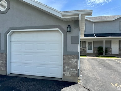
1612 Talon Dr Logan, UT 84321
Woodruff NeighborhoodEstimated payment $1,563/month
Total Views
5,290
2
Beds
1.5
Baths
1,190
Sq Ft
$222
Price per Sq Ft
Highlights
- Mountain View
- Open Patio
- Forced Air Heating and Cooling System
- Cul-De-Sac
- Landscaped
- 1 Car Garage
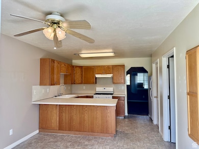
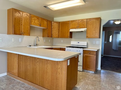
About This Home
BUYERS TO VERIFY HOA
Co-Listing Agent
Teri Dunkley
Century 21 N & N Realtors License #8296767
Townhouse Details
Home Type
- Townhome
Est. Annual Taxes
- $1,117
Year Built
- Built in 1996
Lot Details
- 871 Sq Ft Lot
- Cul-De-Sac
- Partially Fenced Property
- Landscaped
- Sprinkler System
Parking
- 1 Car Garage
- Open Parking
Home Design
- Composition Roof
- Stucco
Interior Spaces
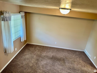
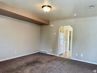
- 1,190 Sq Ft Home
- 2-Story Property
- Blinds
- Mountain Views
- Electric Dryer Hookup
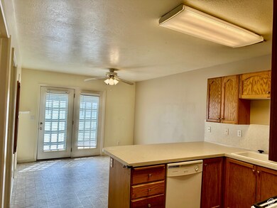
Kitchen
- Range Hood
- Microwave
- Disposal
Flooring
- Carpet
- Vinyl
Bedrooms and Bathrooms
- 2 Bedrooms
Outdoor Features
- Open Patio
Schools
- Woodruff Elementary School
- Mt Logan Middle School
- Logan High School
Utilities
- Forced Air Heating and Cooling System
- Private Sewer
Community Details
- Property has a Home Owners Association
- Burke Nielsen Association, Phone Number (435) 752-5154
- Blackhawk Pud Subdivision
Listing and Financial Details
- Assessor Parcel Number 02-137-0330
Map
Create a Home Valuation Report for This Property
The Home Valuation Report is an in-depth analysis detailing your home's value as well as a comparison with similar homes in the area
Home Values in the Area
Average Home Value in this Area
Tax History
| Year | Tax Paid | Tax Assessment Tax Assessment Total Assessment is a certain percentage of the fair market value that is determined by local assessors to be the total taxable value of land and additions on the property. | Land | Improvement |
|---|---|---|---|---|
| 2024 | $1,117 | $139,920 | $0 | $0 |
| 2023 | $1,232 | $147,180 | $0 | $0 |
| 2022 | $1,357 | $151,250 | $0 | $0 |
| 2021 | $1,155 | $198,890 | $50,000 | $148,890 |
| 2020 | $997 | $154,600 | $30,000 | $124,600 |
| 2019 | $925 | $137,272 | $30,000 | $107,272 |
| 2018 | $910 | $123,280 | $30,000 | $93,280 |
| 2017 | $805 | $57,640 | $0 | $0 |
| 2016 | $835 | $47,685 | $0 | $0 |
| 2015 | $692 | $47,745 | $0 | $0 |
| 2014 | $626 | $47,745 | $0 | $0 |
| 2013 | -- | $47,745 | $0 | $0 |
Source: Public Records
Property History
| Date | Event | Price | Change | Sq Ft Price |
|---|---|---|---|---|
| 06/14/2025 06/14/25 | Price Changed | $264,000 | -1.9% | $222 / Sq Ft |
| 05/29/2025 05/29/25 | Price Changed | $269,000 | -2.2% | $226 / Sq Ft |
| 05/22/2025 05/22/25 | For Sale | $275,000 | -- | $231 / Sq Ft |
Source: UtahRealEstate.com
Purchase History
| Date | Type | Sale Price | Title Company |
|---|---|---|---|
| Warranty Deed | -- | None Available | |
| Warranty Deed | -- | Advanced Title | |
| Interfamily Deed Transfer | -- | Cache Title Company | |
| Interfamily Deed Transfer | -- | Cache Title Company | |
| Interfamily Deed Transfer | -- | Cache Title Company | |
| Warranty Deed | -- | Cache Title Company |
Source: Public Records
Mortgage History
| Date | Status | Loan Amount | Loan Type |
|---|---|---|---|
| Previous Owner | $99,194 | FHA | |
| Previous Owner | $81,855 | New Conventional |
Source: Public Records
Similar Homes in Logan, UT
Source: UtahRealEstate.com
MLS Number: 2086746
APN: 02-137-0330
Disclaimer: Certain information contained herein is derived from information provided by parties other than Homes.com. All information provided is deemed reliable, but is not guaranteed to be accurate and should be independently verified.
![]() IDX information is provided exclusively for consumers’ personal, non-commercial use, that it may not be used for any purpose other than to identify prospective properties consumers may be interested in purchasing, and that the data is deemed reliable but is not guaranteed accurate by the MLS. Licensor is only providing the MLS Content and not other sources of data provided in the Product.
IDX information is provided exclusively for consumers’ personal, non-commercial use, that it may not be used for any purpose other than to identify prospective properties consumers may be interested in purchasing, and that the data is deemed reliable but is not guaranteed accurate by the MLS. Licensor is only providing the MLS Content and not other sources of data provided in the Product.
Based on information from the Wasatch Front Regional Multiple Listing Service, Inc.. All data, including all measurements and calculations of area, is obtained from various sources and has not been, and will not be, verified by broker or the MLS. All information should be independently reviewed and verified for accuracy. Properties may or may not be listed by the office/agent presenting the information.
Nearby Homes
- 1512 Talon Dr
- 162 W 1275 S Unit 162
- 265 W 1395 S
- 49 W 1315 S
- 206 W 1305 S
- 437 S 580 W
- 447 S 580 W
- 475 W 60 S Unit 303
- 472 W 40 S Unit 201
- 473 W 40 S Unit 204
- 460 W 15 S Unit G201
- 470 W 15 S Unit F201
- 460 W 15 S Unit G101
- 460 W 15 S Unit G301
- 462 W 40 S Unit 202
- 427 W 65 S
- 287 S 375 W
- 46 S 410 W
- 600 W 300 S
- 314 W 100 S