
Seller's Agent in 2025
Meridee Carter
Red Oak Realty
(510) 507-0243
1 in this area
63 Total Sales
Estimated Value: $1,160,000 - $1,228,376
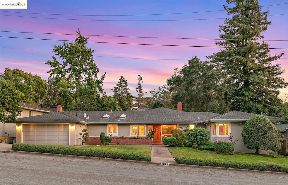
This stunning mid-century retreat is an entertainer’s dream! Nestled in a peaceful corner of LeBrun Estates near the entrance to Lake Chabot Regional Park, the home combines timeless design with modern updates and exceptional indoor-outdoor living. An inviting front patio opens to an expansive living room with grand fireplace, random plank hardwood floors, and a dramatic wall of windows overlooking the lush backyard. The updated kitchen offers stone counters, stainless steel, skylights, recessed lighting, double oven and a five-burner built-in cooktop, opening to a comfortable eat-in area and a formal dining room with built-in cabinetry. Perfect for entertaining, the home includes a large family room with vaulted wood ceilings, skylights, a full bar, and a second fireplace. Sliding glass doors from the family room and third bedroom lead to a private, professionally landscaped backyard - complete with spacious patio, grassy area, mature lemon tree, and covered outdoor fireplace. A generous primary suite provides three closets, a large vanity, and a walk-in shower. The attached two-car garage offers laundry facilities, a workshop area, and ample built-in storage. Instant access to 580, Lake Chabot and downtown San Leandro. Bath count and square footage differ. Buyer to investigate.
Last Agent to Sell the Property
Red Oak Realty License #01269227 Listed on: 10/28/2025
We collect this data history from publicly available records. To have your information removed, we recommend requesting removal directly through your county’s website.
| Date | Buyer | Sale Price | Title Company |
|---|---|---|---|
| Zeng Timothy | $1,200,000 | Chicago Title | |
| Ditano Rita M | -- | Chicago Title Company | |
| Ditano Rita M | -- | Chicago Title Company | |
| Italo Di Tano & Rita M Di Tano 2004 Trus | -- | None Available | |
| Ditano Italo | $700,000 | Old Republic Title Company |
We collect this data history from publicly available records. To have your information removed, we recommend requesting removal directly through your county’s website.
| Date | Status | Borrower | Loan Amount |
|---|---|---|---|
| Open | Zeng Timothy | $450,000 | |
| Previous Owner | Ditano Rita M | $358,000 | |
| Previous Owner | Ditano Italo | $525,000 |
| Date | Event | Price | List to Sale | Price per Sq Ft |
|---|---|---|---|---|
| 12/15/2025 12/15/25 | Sold | $1,200,000 | +0.1% | $481 / Sq Ft |
| 11/13/2025 11/13/25 | Pending | -- | -- | -- |
| 10/28/2025 10/28/25 | For Sale | $1,199,000 | -- | $480 / Sq Ft |
| Year | Tax Paid | Tax Assessment Tax Assessment Total Assessment is a certain percentage of the fair market value that is determined by local assessors to be the total taxable value of land and additions on the property. | Land | Improvement |
|---|---|---|---|---|
| 2025 | $11,673 | $896,510 | $271,053 | $632,457 |
| 2024 | $11,673 | $878,800 | $265,740 | $620,060 |
| 2023 | $11,609 | $868,433 | $260,530 | $607,903 |
| 2022 | $11,285 | $844,410 | $255,423 | $595,987 |
| 2021 | $10,946 | $827,721 | $250,416 | $584,305 |
| 2020 | $10,672 | $826,167 | $247,850 | $578,317 |
| 2019 | $10,354 | $809,970 | $242,991 | $566,979 |
| 2018 | $10,100 | $794,093 | $238,228 | $555,865 |
| 2017 | $9,892 | $778,525 | $233,557 | $544,968 |
| 2016 | $9,371 | $763,265 | $228,979 | $534,286 |
| 2015 | $9,205 | $751,806 | $225,542 | $526,264 |
| 2014 | $9,134 | $737,085 | $221,125 | $515,960 |
Seller's Agent in 2025
Meridee Carter
Red Oak Realty
(510) 507-0243
1 in this area
63 Total Sales
Seller Co-Listing Agent in 2025
Ben Levin
Red Oak Realty
(510) 600-2222
1 in this area
59 Total Sales
Buyer's Agent in 2025
Alexander Jung Han
Fifty Hills Real Estate
(415) 819-6116
1 in this area
42 Total Sales
Source: bridgeMLS
MLS Number: 41116040
APN: 079-0122-002-00
Disclaimer: Certain information contained herein is derived from information provided by parties other than Homes.com. All information provided is deemed reliable, but is not guaranteed to be accurate and should be independently verified.
![]() Bay East 2026. CCAR 2026. bridgeMLS 2026. Information Deemed Reliable But Not Guaranteed. This information is being provided by the Bay East MLS, or CCAR MLS, or bridgeMLS. The listings presented here may or may not be listed by the Broker/Agent operating this website. This information is intended for the personal use of consumers and may not be used for any purpose other than to identify prospective properties consumers may be interested in purchasing.
Bay East 2026. CCAR 2026. bridgeMLS 2026. Information Deemed Reliable But Not Guaranteed. This information is being provided by the Bay East MLS, or CCAR MLS, or bridgeMLS. The listings presented here may or may not be listed by the Broker/Agent operating this website. This information is intended for the personal use of consumers and may not be used for any purpose other than to identify prospective properties consumers may be interested in purchasing.
Ask me questions while you tour the home.