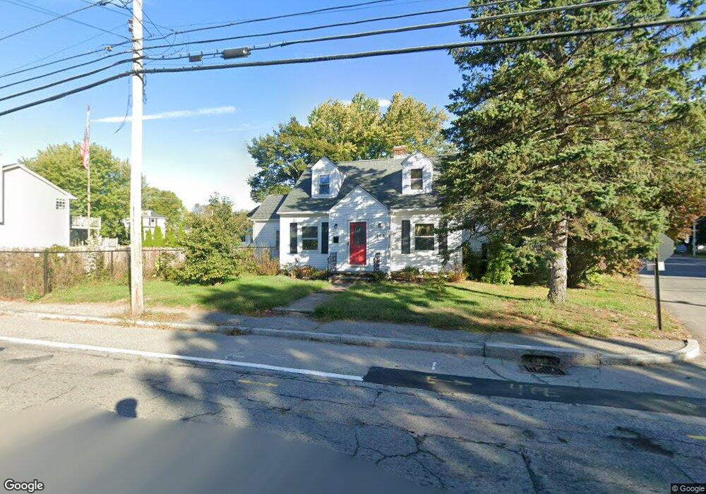
162 Dexter St Cumberland, RI 02864
Valley Falls NeighborhoodEstimated Value: $435,000 - $461,000
3
Beds
2
Baths
1,687
Sq Ft
$265/Sq Ft
Est. Value
About This Home
This home is located at 162 Dexter St, Cumberland, RI 02864 and is currently estimated at $447,482, approximately $265 per square foot. 162 Dexter St is a home located in Providence County with nearby schools including B.F. Norton Elementary School, Joseph L. McCourt Middle School, and Cumberland High School.
Ownership History
Date
Name
Owned For
Owner Type
Purchase Details
Closed on
Aug 30, 2019
Sold by
Williams Michael R
Bought by
Williams Ret
Current Estimated Value
Purchase Details
Closed on
May 5, 2006
Sold by
Sacco Michael D and Poutre-Sacco Suzanne Y
Bought by
Williams Michael R
Purchase Details
Closed on
Aug 1, 2001
Sold by
Hopkinson Scott A and Pallas Gregory S
Bought by
Sacco Michael D
Purchase Details
Closed on
Oct 25, 1988
Sold by
Shepardson Richard
Bought by
Hopkinson Scott A
Create a Home Valuation Report for This Property
The Home Valuation Report is an in-depth analysis detailing your home's value as well as a comparison with similar homes in the area
Home Values in the Area
Average Home Value in this Area
Purchase History
| Date | Buyer | Sale Price | Title Company |
|---|---|---|---|
| Williams Ret | -- | -- | |
| Williams Michael R | $230,000 | -- | |
| Sacco Michael D | $187,000 | -- | |
| Hopkinson Scott A | $119,000 | -- |
Source: Public Records
Mortgage History
| Date | Status | Borrower | Loan Amount |
|---|---|---|---|
| Previous Owner | Hopkinson Scott A | $100,000 | |
| Previous Owner | Hopkinson Scott A | $66,000 |
Source: Public Records
Tax History
| Year | Tax Paid | Tax Assessment Tax Assessment Total Assessment is a certain percentage of the fair market value that is determined by local assessors to be the total taxable value of land and additions on the property. | Land | Improvement |
|---|---|---|---|---|
| 2025 | $4,142 | $337,600 | $144,600 | $193,000 |
| 2024 | $4,034 | $337,600 | $144,600 | $193,000 |
| 2023 | $3,923 | $337,600 | $144,600 | $193,000 |
| 2022 | $3,716 | $247,900 | $101,100 | $146,800 |
| 2021 | $3,465 | $247,900 | $101,100 | $146,800 |
| 2020 | $3,550 | $247,900 | $101,100 | $146,800 |
| 2019 | $3,295 | $216,000 | $84,400 | $131,600 |
| 2018 | $858 | $216,000 | $84,400 | $131,600 |
| 2017 | $3,285 | $216,000 | $84,400 | $131,600 |
| 2016 | $3,018 | $176,700 | $76,800 | $99,900 |
| 2015 | $3,018 | $176,700 | $76,800 | $99,900 |
| 2014 | $3,611 | $176,700 | $76,800 | $99,900 |
| 2013 | $2,839 | $179,900 | $77,200 | $102,700 |
Source: Public Records
Map
Nearby Homes
- 134 Dexter St
- 23 Hewes St
- 15 E Earle St
- 36 Dexter St
- 28 Crowell St
- 50 Blackstone St
- 26 Hopkins Terrace
- 18 Cumberland St
- 33 Kent St
- 500 Mendon Rd Unit 257
- 519 Mendon Rd Unit 519
- 517 Mendon Rd Unit 517
- 513 Mendon Rd Unit 513
- 515 Mendon Rd Unit 515
- 511 Mendon Rd Unit 511
- 509 Mendon Rd Unit 509
- 6 Castle Rd
- 27 Norman St
- 117 John St Unit 1
- 789 High St
- 12 Bryant St
- 157 Dexter St
- 161 Dexter St
- 140 Dexter St
- 165 Dexter St
- 13 Minerva Ave
- 153 Dexter St
- 16 Bryant St
- 15 Bryant St
- 15 Minerva Ave
- 22 Bryant St
- 176 Dexter St
- 151 Dexter St
- 21 Bryant St
- 169 Dexter St
- 6 Minerva Ave
- 0 Minerva Ave Unit 608471
- 0 Minerva Ave Unit 608465
- 0 Minerva Ave Unit 437079
- 0 Minerva Ave Unit 614611
Your Personal Tour Guide
Ask me questions while you tour the home.