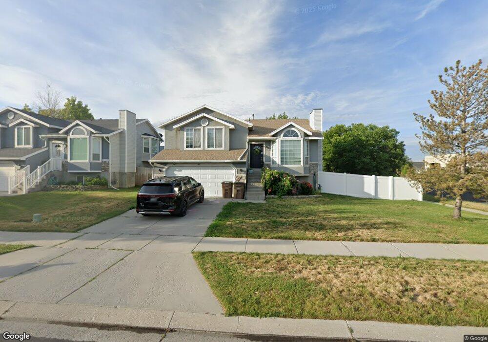
162 E Bridgepark Cir Draper, UT 84020
Estimated Value: $585,000 - $823,000
4
Beds
3
Baths
2,174
Sq Ft
$316/Sq Ft
Est. Value
About This Home
This home is located at 162 E Bridgepark Cir, Draper, UT 84020 and is currently estimated at $686,371, approximately $315 per square foot. 162 E Bridgepark Cir is a home located in Salt Lake County with nearby schools including Corner Canyon High School, Draper Park Middle School, and Channing Hall.
Ownership History
Date
Name
Owned For
Owner Type
Purchase Details
Closed on
Feb 24, 2000
Sold by
Kram Steve M and Kram Hinemoa C
Bought by
Smith Michael and Smith Shawnee
Current Estimated Value
Purchase Details
Closed on
Jun 30, 1998
Sold by
Sanocki Terence
Bought by
Kram Steve M and Kram Hinemoa C
Home Financials for this Owner
Home Financials are based on the most recent Mortgage that was taken out on this home.
Original Mortgage
$165,830
Interest Rate
7.06%
Mortgage Type
VA
Purchase Details
Closed on
May 21, 1996
Sold by
Glen Pettit Inc
Bought by
Sanocki Terence
Home Financials for this Owner
Home Financials are based on the most recent Mortgage that was taken out on this home.
Original Mortgage
$115,000
Interest Rate
8.07%
Purchase Details
Closed on
Dec 30, 1994
Sold by
Tgc Enterprises Inc
Bought by
Glen Pettit Inc
Create a Home Valuation Report for This Property
The Home Valuation Report is an in-depth analysis detailing your home's value as well as a comparison with similar homes in the area
Home Values in the Area
Average Home Value in this Area
Purchase History
| Date | Buyer | Sale Price | Title Company |
|---|---|---|---|
| Smith Michael | -- | Metro National Title | |
| Kram Steve M | -- | -- | |
| Sanocki Terence | -- | -- | |
| Glen Pettit Inc | -- | -- |
Source: Public Records
Mortgage History
| Date | Status | Borrower | Loan Amount |
|---|---|---|---|
| Previous Owner | Kram Steve M | $165,830 | |
| Previous Owner | Sanocki Terence | $115,000 |
Source: Public Records
Tax History
| Year | Tax Paid | Tax Assessment Tax Assessment Total Assessment is a certain percentage of the fair market value that is determined by local assessors to be the total taxable value of land and additions on the property. | Land | Improvement |
|---|---|---|---|---|
| 2025 | $2,771 | $529,500 | $216,700 | $312,800 |
| 2024 | $2,771 | $509,200 | $208,700 | $300,500 |
| 2023 | $2,643 | $501,200 | $203,800 | $297,400 |
| 2022 | $2,785 | $510,100 | $199,800 | $310,300 |
| 2021 | $2,385 | $373,100 | $188,300 | $184,800 |
| 2020 | $2,302 | $333,300 | $175,000 | $158,300 |
| 2019 | $2,289 | $331,700 | $175,000 | $156,700 |
| 2016 | $2,139 | $294,900 | $162,200 | $132,700 |
Source: Public Records
Map
Nearby Homes
- 208 Spencer Peak Way Unit E2
- 352 E Mistilake Ln Unit 20
- 311 E Unchartered Ln
- 13176 Day Ct
- 13160 S 300 E
- 633 E Vandalay Ln
- 181 Mountain Peak Dr
- 246 W Golden Harvest Rd
- 13208 Sunset Glen Way
- 265 E 13275 S
- 12062 S 540 E
- 186 E Kimballfield Ln
- 264 W 13165 S
- 11873 Cottage View Ln
- 847 E Willow Springs Ln
- 902 E 12650 S
- 12235 S Ryder Ct
- 13554 Bella Monte Dr Unit 113
- 834 E 12085 S
- 13520 S Lone Rock Dr
- 162 Bridgepark Cir
- 172 Bridgepark Cir
- 172 E Bridgepark Cir
- 159 Stonepark Cir
- 159 E Stonepark Cir
- 178 Bridgepark Cir
- 178 E Bridgepark Cir
- 169 Stonepark Cir
- 184 Bridgepark Cir
- 184 E Bridgepark Cir
- 12627 S 150 E
- 169 Bridgepark Cir
- 12652 S 150 E
- 177 E Bridgepark Cir
- 177 Bridgepark Cir
- 194 E Bridgepark Cir
- 189 Stonepark Cir
- 183 Bridgepark Cir
- 12636 S 150 E
- 185 Stonepark Cir
Your Personal Tour Guide
Ask me questions while you tour the home.