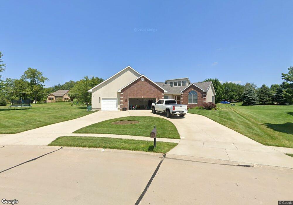
1620 15th Ave de Witt, IA 52742
Estimated Value: $393,000 - $575,000
--
Bed
5
Baths
2,157
Sq Ft
$232/Sq Ft
Est. Value
About This Home
This home is located at 1620 15th Ave, de Witt, IA 52742 and is currently estimated at $501,028, approximately $232 per square foot. 1620 15th Ave is a home located in Clinton County with nearby schools including Ekstrand Elementary School, Central Dewitt Intermediate School, and Central Dewitt Middle School.
Ownership History
Date
Name
Owned For
Owner Type
Purchase Details
Closed on
Oct 1, 2021
Sold by
Connolly Chris J and Connolly Connie J
Bought by
Bock Joseph and Bock Jennifer
Current Estimated Value
Home Financials for this Owner
Home Financials are based on the most recent Mortgage that was taken out on this home.
Original Mortgage
$469,900
Outstanding Balance
$427,574
Interest Rate
2.8%
Mortgage Type
VA
Estimated Equity
$73,454
Purchase Details
Closed on
Jun 2, 2006
Sold by
Wiese Timothy J and Wiese Jodi L
Bought by
Connolly Chris and Connolly Connie J
Home Financials for this Owner
Home Financials are based on the most recent Mortgage that was taken out on this home.
Original Mortgage
$207,500
Interest Rate
6.68%
Mortgage Type
New Conventional
Create a Home Valuation Report for This Property
The Home Valuation Report is an in-depth analysis detailing your home's value as well as a comparison with similar homes in the area
Home Values in the Area
Average Home Value in this Area
Purchase History
| Date | Buyer | Sale Price | Title Company |
|---|---|---|---|
| Bock Joseph | $500,000 | Oshea & Oshea Pc | |
| Connolly Chris | $307,500 | None Available |
Source: Public Records
Mortgage History
| Date | Status | Borrower | Loan Amount |
|---|---|---|---|
| Open | Bock Joseph | $469,900 | |
| Previous Owner | Connolly Chris | $207,500 |
Source: Public Records
Tax History Compared to Growth
Tax History
| Year | Tax Paid | Tax Assessment Tax Assessment Total Assessment is a certain percentage of the fair market value that is determined by local assessors to be the total taxable value of land and additions on the property. | Land | Improvement |
|---|---|---|---|---|
| 2025 | $214 | $600,150 | $51,650 | $548,500 |
| 2024 | $214 | $539,220 | $51,650 | $487,570 |
| 2023 | $8,020 | $539,220 | $51,650 | $487,570 |
| 2022 | $8,020 | $482,480 | $51,650 | $430,830 |
| 2021 | $7,772 | $403,940 | $48,400 | $355,540 |
| 2020 | $7,772 | $373,020 | $48,400 | $324,620 |
| 2019 | $7,440 | $357,560 | $0 | $0 |
| 2018 | $7,260 | $357,560 | $0 | $0 |
| 2017 | $6,746 | $357,560 | $0 | $0 |
| 2016 | $6,466 | $0 | $0 | $0 |
| 2015 | $6,466 | $319,100 | $0 | $0 |
| 2014 | $6,550 | $319,100 | $0 | $0 |
| 2013 | $6,444 | $0 | $0 | $0 |
Source: Public Records
Map
Nearby Homes
- 1614 15th Ave
- 1429 Mackin Dr
- 1432 Mackin Dr
- 1601 Silver Valley Dr
- 1532 Mackin Dr
- 1318 Springbrook Ln
- 1320 Forest St
- 1412 14th Ave
- 1549 Silver Valley Dr
- 1320 Forest Ct
- 1503 Mackin Dr
- 1508 Mackin Dr
- 1600 14th Ave
- 1315 Forest St
- 1316 Forest Ct
- 1600 Silver Valley Dr
- 1516 15th Ave
- 1511 Mackin Dr
- 1316 Elm Ct
- 1319 Forest Ct