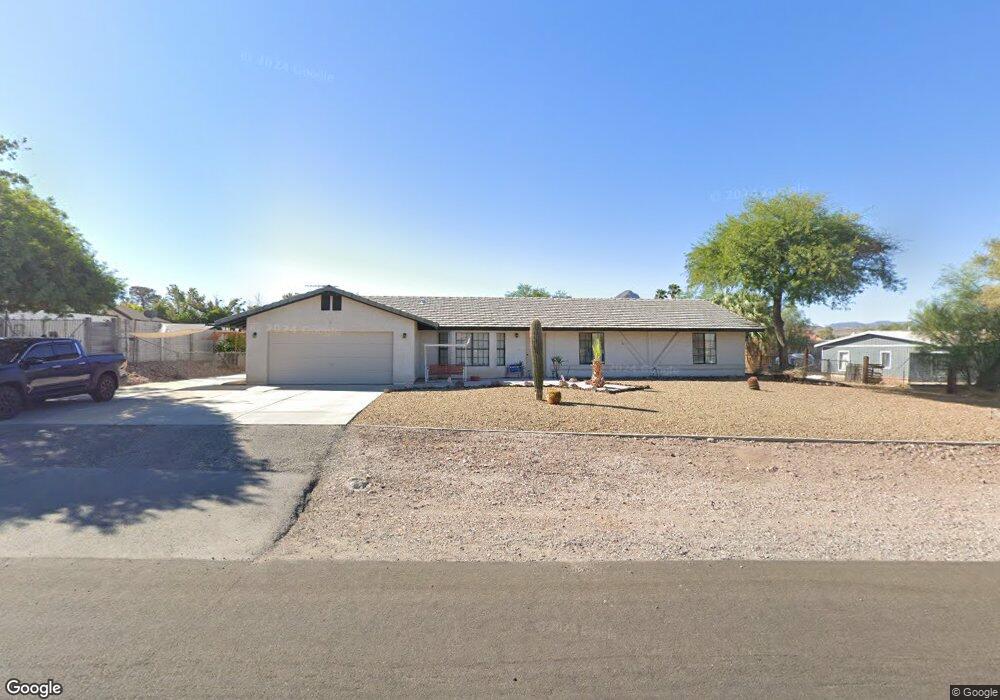
1621 Stirrup Dr Henderson, NV 89002
River Mountain NeighborhoodEstimated Value: $539,221 - $609,000
4
Beds
2
Baths
1,970
Sq Ft
$292/Sq Ft
Est. Value
About This Home
This home is located at 1621 Stirrup Dr, Henderson, NV 89002 and is currently estimated at $576,055, approximately $292 per square foot. 1621 Stirrup Dr is a home located in Clark County with nearby schools including John Dooley Elementary School, B Mahlon Brown Academy of International Studies, and Basic Academy of International Studies.
Ownership History
Date
Name
Owned For
Owner Type
Purchase Details
Closed on
Jun 29, 2017
Sold by
Tucci Fred S
Bought by
Tucci Fred S and Tvk Rink Family Trust
Current Estimated Value
Purchase Details
Closed on
May 18, 2012
Sold by
Rink Thomas J and Rink Vera J
Bought by
Rink Thomas J and Rink Vera J
Purchase Details
Closed on
Feb 10, 1997
Sold by
Rink Thomas J and Rink Vera J
Bought by
The City Of Henderson
Purchase Details
Closed on
Sep 15, 1994
Sold by
Tontsch William G and Tontsch Mary Ann
Bought by
Rink Thomas J and Rink Vera J
Create a Home Valuation Report for This Property
The Home Valuation Report is an in-depth analysis detailing your home's value as well as a comparison with similar homes in the area
Home Values in the Area
Average Home Value in this Area
Purchase History
| Date | Buyer | Sale Price | Title Company |
|---|---|---|---|
| Tucci Fred S | -- | None Available | |
| Rink Thomas J | -- | None Available | |
| The City Of Henderson | -- | -- | |
| Rink Thomas J | $155,000 | Nevada Title Company |
Source: Public Records
Tax History Compared to Growth
Tax History
| Year | Tax Paid | Tax Assessment Tax Assessment Total Assessment is a certain percentage of the fair market value that is determined by local assessors to be the total taxable value of land and additions on the property. | Land | Improvement |
|---|---|---|---|---|
| 2025 | $2,080 | $113,334 | $49,000 | $64,334 |
| 2024 | $2,080 | $113,334 | $49,000 | $64,334 |
| 2023 | $2,080 | $113,853 | $52,500 | $61,353 |
| 2022 | $2,020 | $102,099 | $45,500 | $56,599 |
| 2021 | $1,961 | $89,263 | $35,000 | $54,263 |
| 2020 | $1,901 | $96,242 | $42,000 | $54,242 |
| 2019 | $1,878 | $85,101 | $31,500 | $53,601 |
| 2018 | $1,792 | $81,005 | $29,050 | $51,955 |
| 2017 | $2,345 | $80,900 | $28,000 | $52,900 |
| 2016 | $1,678 | $74,433 | $21,000 | $53,433 |
| 2015 | $1,674 | $58,420 | $14,000 | $44,420 |
| 2014 | $1,625 | $54,433 | $14,000 | $40,433 |
Source: Public Records
Map
Nearby Homes
- 2120 Thoroughbred Rd
- 2413 Gold Camp St
- 2357 Mundare Dr
- 1549 Broken Bell Ln
- 2193 Red Alder St
- 1590 Mustang Dr
- 1586 Rusty Ridge Ln
- 1581 Latigo Dr
- 2181 Maple Shade St
- 1629 Lone Palm Ct
- 2269 Sky Island Dr
- 1554 Ward Frontier Ln
- 1557 Ward Frontier Ln
- 2509 April Breeze Ln
- 2560 Alias Smith Dr
- 2031 Buckeye Reef St
- 2169 Rio Rancho Pointe Place
- 2566 Velez Valley Way
- 2567 Land Rush Dr
- 2006 Darla St
- 1631 Stirrup Dr
- 1611 Stirrup Dr
- 1620 Tumbleweed Dr
- 1630 Tumbleweed Dr
- 1610 Tumbleweed Dr
- 1620 Stirrup Dr
- 1610 Stirrup Dr
- 2241 Thoroughbred Rd
- 1601 Stirrup Dr
- 2231 Thoroughbred Rd
- 1600 Tumbleweed Dr
- 2230 Roan Rd
- 1621 Tumbleweed Dr
- 1621 Sundown Dr
- 1631 Tumbleweed Dr
- 1611 Sundown Dr
- 1611 Tumbleweed Dr
- 2221 Thoroughbred Rd
- 1641 Tumbleweed Dr
- 1601 Sundown Dr