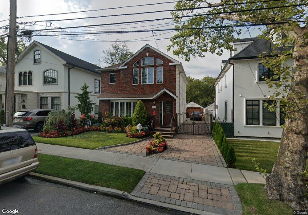
16211 12th Rd Whitestone, NY 11357
Whitestone NeighborhoodEstimated Value: $1,459,000 - $1,562,000
Studio
--
Bath
2,150
Sq Ft
$701/Sq Ft
Est. Value
About This Home
This home is located at 16211 12th Rd, Whitestone, NY 11357 and is currently estimated at $1,507,420, approximately $701 per square foot. 16211 12th Rd is a home located in Queens County with nearby schools including P.S. 193 - Alfred J. Kennedy, J.H.S. 194 William Carr, and Bayside High School.
Ownership History
Date
Name
Owned For
Owner Type
Purchase Details
Closed on
Feb 5, 2020
Sold by
Carbonara Peter and Carbonara Margherita P
Bought by
Lin Jin
Current Estimated Value
Purchase Details
Closed on
Feb 3, 1997
Sold by
Hewitt George E
Bought by
Carbonara Peter and Carbonara Margherita P
Home Financials for this Owner
Home Financials are based on the most recent Mortgage that was taken out on this home.
Original Mortgage
$165,000
Interest Rate
7.59%
Create a Home Valuation Report for This Property
The Home Valuation Report is an in-depth analysis detailing your home's value as well as a comparison with similar homes in the area
Home Values in the Area
Average Home Value in this Area
Purchase History
| Date | Buyer | Sale Price | Title Company |
|---|---|---|---|
| Lin Jin | $1,210,000 | -- | |
| Carbonara Peter | $225,000 | Commonwealth Land Title Ins |
Source: Public Records
Mortgage History
| Date | Status | Borrower | Loan Amount |
|---|---|---|---|
| Previous Owner | Carbonara Peter | $165,000 |
Source: Public Records
Tax History
| Year | Tax Paid | Tax Assessment Tax Assessment Total Assessment is a certain percentage of the fair market value that is determined by local assessors to be the total taxable value of land and additions on the property. | Land | Improvement |
|---|---|---|---|---|
| 2025 | $13,661 | $70,402 | $12,213 | $58,189 |
| 2024 | $13,661 | $68,014 | $12,044 | $55,970 |
| 2023 | $13,565 | $66,791 | $13,051 | $53,740 |
| 2022 | $9,434 | $77,820 | $16,320 | $61,500 |
| 2021 | $12,790 | $75,120 | $16,320 | $58,800 |
| 2020 | $12,418 | $67,320 | $16,320 | $51,000 |
| 2019 | $11,856 | $59,760 | $16,320 | $43,440 |
| 2018 | $11,346 | $55,659 | $13,006 | $42,653 |
| 2017 | $10,203 | $52,510 | $15,146 | $37,364 |
| 2016 | $9,815 | $52,510 | $15,146 | $37,364 |
| 2015 | $5,755 | $48,890 | $16,189 | $32,701 |
| 2014 | $5,755 | $47,232 | $16,981 | $30,251 |
Source: Public Records
Map
Nearby Homes
- 16207 12th Rd
- 16015 13th Ave
- 16008 12th Rd
- 160-32 11th Ave
- 16255 12th Ave
- 10-24 166th St Unit 3A
- 10-24 166th St Unit 7C
- 14-15 160th St Unit 5-94
- 10-10 166th St Unit 4A
- 10-01 162nd St Unit 4A
- 1009 166th St
- 9-20 166th St Unit 3B
- 9-05 162nd St Unit 6D
- 14-21 159th St
- 160-03 Cryders Ln
- 162-20 9th Ave Unit 2A
- 162-40 9th Ave Unit 7A
- 162-40 9th Ave Unit 3B
- 162-40 9th Ave Unit 8B
- 10-33 Burton St
Your Personal Tour Guide
Ask me questions while you tour the home.