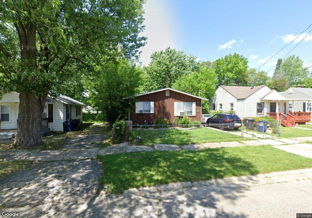
1622 Pettibone Ave Flint, MI 48507
South Side NeighborhoodEstimated Value: $50,654 - $59,000
3
Beds
1
Bath
954
Sq Ft
$57/Sq Ft
Est. Value
About This Home
This home is located at 1622 Pettibone Ave, Flint, MI 48507 and is currently estimated at $54,414, approximately $57 per square foot. 1622 Pettibone Ave is a home located in Genesee County with nearby schools including Neithercut Elementary School, Flint Southwestern Classical Academy, and International Academy of Flint (K-12).
Ownership History
Date
Name
Owned For
Owner Type
Purchase Details
Closed on
Aug 1, 2022
Sold by
Genesee County Land Bank Authority
Bought by
North Nicole Kristine
Current Estimated Value
Purchase Details
Closed on
Sep 2, 2020
Sold by
The Genesee County Land Bank Authority
Bought by
North Nicole Kristine
Purchase Details
Closed on
Dec 19, 2019
Sold by
Cherry Deborah L
Bought by
County Land Bank Authority
Create a Home Valuation Report for This Property
The Home Valuation Report is an in-depth analysis detailing your home's value as well as a comparison with similar homes in the area
Home Values in the Area
Average Home Value in this Area
Purchase History
| Date | Buyer | Sale Price | Title Company |
|---|---|---|---|
| North Nicole Kristine | $14,000 | None Listed On Document | |
| North Nicole Kristine | -- | None Available | |
| County Land Bank Authority | -- | None Available |
Source: Public Records
Mortgage History
| Date | Status | Borrower | Loan Amount |
|---|---|---|---|
| Closed | North Nicole Kristine | $0 |
Source: Public Records
Tax History Compared to Growth
Tax History
| Year | Tax Paid | Tax Assessment Tax Assessment Total Assessment is a certain percentage of the fair market value that is determined by local assessors to be the total taxable value of land and additions on the property. | Land | Improvement |
|---|---|---|---|---|
| 2025 | $1,079 | $15,800 | $0 | $0 |
| 2024 | $1,001 | $15,800 | $0 | $0 |
| 2023 | $979 | $13,300 | $0 | $0 |
| 2022 | $0 | $11,300 | $0 | $0 |
| 2021 | $992 | $10,000 | $0 | $0 |
| 2020 | $268 | $0 | $0 | $0 |
| 2019 | $851 | $9,000 | $0 | $0 |
| 2018 | $1,086 | $14,100 | $0 | $0 |
| 2017 | $1,057 | $0 | $0 | $0 |
| 2016 | $1,049 | $0 | $0 | $0 |
| 2015 | -- | $0 | $0 | $0 |
| 2014 | -- | $0 | $0 | $0 |
| 2012 | -- | $16,300 | $0 | $0 |
Source: Public Records
Map
Nearby Homes
- 1523 Waldman Ave
- 1741 Carmanbrook Pkwy
- 1814 Carmanbrook Pkwy
- 1727 Briarwood Dr
- 1410 Berrywood Ln
- 1225 Waldman Ave
- 1902 Crestbrook Ln
- 1209 Lincoln Ave
- 1607 Mulberry Ln
- 1418 Blueberry Ln
- 1228 Leland St
- 2107 Stoney Brook Ct
- 1416 Blackberry Ln
- 4101 Greenbrook Ln
- 1101 Lincoln Ave
- 1212 Crawford St
- 1102 W Atherton Rd
- 1826 Greenbrook Ln
- 1329 Huron St
- 1310 Huron St
- 1618 Pettibone Ave
- 1626 Pettibone Ave
- 1614 Pettibone Ave
- 1621 Lincoln Ave
- 1617 Lincoln Ave
- 1625 Lincoln Ave
- 1634 Pettibone Ave
- 1613 Lincoln Ave
- 1610 Pettibone Ave
- 1623 Pettibone Ave
- 1619 Pettibone Ave
- 1609 Lincoln Ave
- 1633 Lincoln Ave
- 1627 Pettibone Ave
- 1615 Pettibone Ave
- 1606 Pettibone Ave
- 1638 Pettibone Ave
- 1631 Pettibone Ave
- 1611 Pettibone Ave
- 1637 Lincoln Ave