Estimated Value: $245,000 - $287,000
4
Beds
2
Baths
2,100
Sq Ft
$127/Sq Ft
Est. Value
About This Home
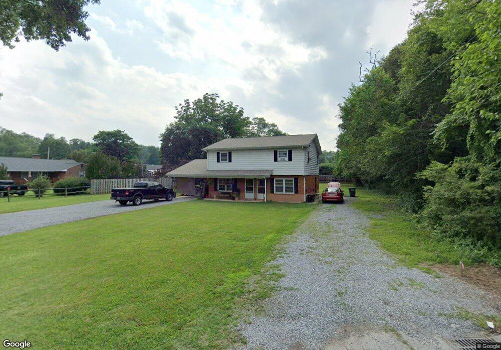
This home is located at 1624 E Riverside Dr Unit 1624 & 1626, Salem, VA 24153 and is currently estimated at $265,957, approximately $126 per square foot. 1624 E Riverside Dr Unit 1624 & 1626 is a home located in Salem City with nearby schools including East Salem Elementary School, Andrew Lewis Middle School, and Salem High School.
Ownership History
Date
Name
Owned For
Owner Type
Purchase Details
Closed on
May 4, 2021
Sold by
May Dale E and May Living Trust
Bought by
May Dale Edward and Dale Edward May Revocable Trus
Current Estimated Value
Purchase Details
Closed on
Aug 26, 2011
Sold by
Haynes Deborah Lynn
Bought by
May Dale E and May Margery F
Purchase Details
Closed on
Nov 4, 2008
Sold by
Sat Development Llc
Bought by
Haynes Deborah Lynn
Purchase Details
Closed on
Apr 16, 2007
Sold by
Beveridge Paul F and Beveridge Nancy T
Bought by
Sat Development Llc
Home Financials for this Owner
Home Financials are based on the most recent Mortgage that was taken out on this home.
Original Mortgage
$110,000
Interest Rate
6.23%
Mortgage Type
Purchase Money Mortgage
Create a Home Valuation Report for This Property
The Home Valuation Report is an in-depth analysis detailing your home's value as well as a comparison with similar homes in the area
Home Values in the Area
Average Home Value in this Area
Purchase History
| Date | Buyer | Sale Price | Title Company |
|---|---|---|---|
| May Dale Edward | -- | None Available | |
| May Dale E | $132,500 | Fidelity National Title Insu | |
| Haynes Deborah Lynn | -- | Title Source Inc | |
| Sat Development Llc | $141,000 | None Available |
Source: Public Records
Mortgage History
| Date | Status | Borrower | Loan Amount |
|---|---|---|---|
| Previous Owner | Sat Development Llc | $110,000 |
Source: Public Records
Tax History Compared to Growth
Tax History
| Year | Tax Paid | Tax Assessment Tax Assessment Total Assessment is a certain percentage of the fair market value that is determined by local assessors to be the total taxable value of land and additions on the property. | Land | Improvement |
|---|---|---|---|---|
| 2025 | $979 | $166,000 | $43,000 | $123,000 |
| 2024 | $877 | $146,200 | $39,500 | $106,700 |
| 2023 | $1,615 | $134,600 | $36,100 | $98,500 |
| 2022 | $1,584 | $132,000 | $34,400 | $97,600 |
| 2021 | $1,553 | $129,400 | $32,600 | $96,800 |
| 2020 | $1,495 | $124,600 | $32,600 | $92,000 |
| 2019 | $1,460 | $121,700 | $32,600 | $89,100 |
| 2018 | $1,404 | $119,000 | $31,000 | $88,000 |
| 2017 | $1,597 | $135,300 | $31,000 | $104,300 |
| 2016 | $1,597 | $135,300 | $31,000 | $104,300 |
| 2015 | $1,562 | $132,400 | $22,500 | $109,900 |
| 2014 | $1,562 | $132,400 | $22,500 | $109,900 |
Source: Public Records
Map
Nearby Homes
- 1410 Orchard Dr
- 1647 Margaret Ln
- 1943 Maylin Dr
- 2405 Carriage House Ct
- 2503 Gatehouse Ln
- 2513 Gatehouse Ln
- 2408 Wood Gate Ln
- 2404 Post Oak Rd
- 1930 McVitty Rd
- 23 Upland Dr
- 2403 Post Oak Rd
- 0 Keagy Rd Unit 918464
- 2391 Romar Dr
- 5319 McVitty Rd
- 1315 Keagy Ln SW
- 1318 Keagy Ln SW
- 303 Riverland Dr
- 180 Forest Dr
- 1002 Roanoke Blvd
- The Nantucket Plan at Simms Farm
- 1624 E Riverside Dr Unit 1626
- 1029 Tremont Rd
- 1600 E Riverside Dr
- 1021 Tremont Rd
- 1020 Apperson Dr
- 1015 Tremont Rd
- 1608 Brookland Dr
- 1601 Electric Rd
- 1008 Apperson Dr
- 1005 Tremont Rd
- 1028 Tremont Rd
- 1002 Apperson Dr
- 1600 Electric Rd
- 1016 Tremont Rd
- 1004 Apperson Dr
- 935 Tremont Rd
- 1715 E Riverside Dr
- 1000 Tremont Rd
- 1015 Apperson Dr
- 1037 E Riverside Dr