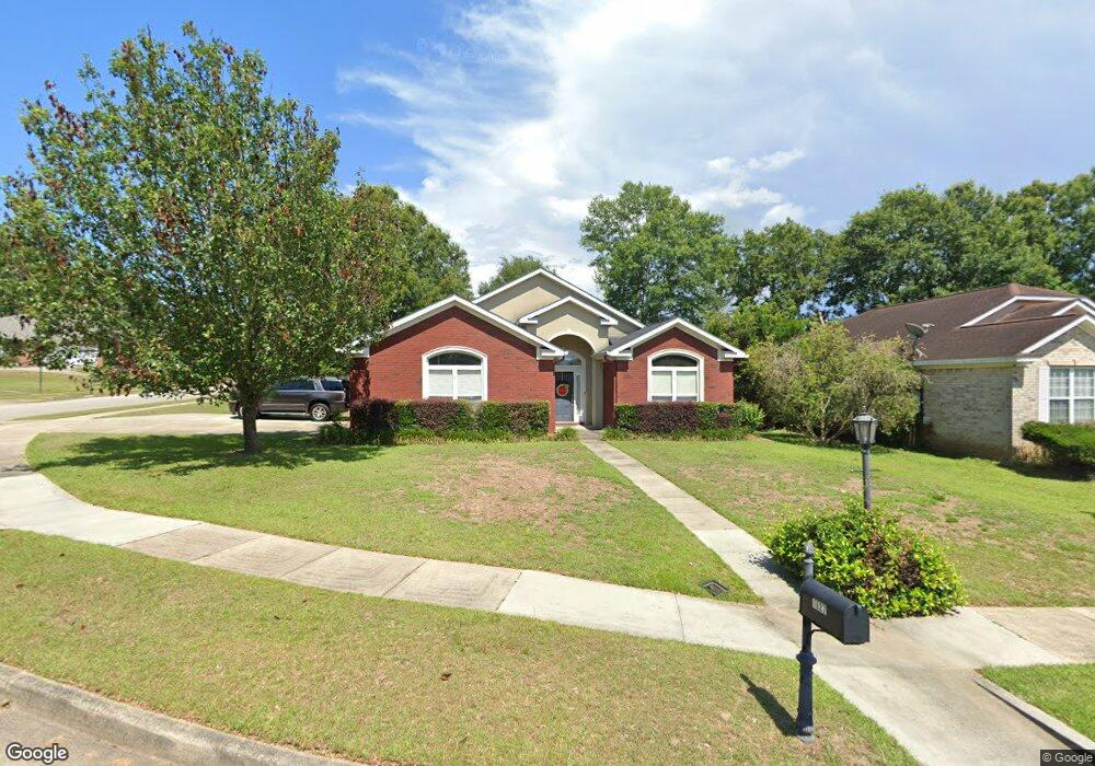
1627 Ashmoor Dr W Mobile, AL 36695
Second Creek NeighborhoodEstimated Value: $285,800 - $331,000
3
Beds
3
Baths
2,065
Sq Ft
$146/Sq Ft
Est. Value
About This Home
This home is located at 1627 Ashmoor Dr W, Mobile, AL 36695 and is currently estimated at $301,700, approximately $146 per square foot. 1627 Ashmoor Dr W is a home located in Mobile County with nearby schools including O'rourke Elementary School, Burns Middle School, and WP Davidson High School.
Ownership History
Date
Name
Owned For
Owner Type
Purchase Details
Closed on
Sep 19, 2018
Sold by
Buell Jane S
Bought by
Bush Margaret Neely
Current Estimated Value
Purchase Details
Closed on
Aug 12, 2008
Sold by
Farmer William M and Farmer Courtnay Shae
Bought by
Buell Jane S
Purchase Details
Closed on
Jul 21, 2004
Sold by
Jbl Properties Ltd
Bought by
Farmer William M
Home Financials for this Owner
Home Financials are based on the most recent Mortgage that was taken out on this home.
Original Mortgage
$141,784
Interest Rate
5.25%
Mortgage Type
New Conventional
Create a Home Valuation Report for This Property
The Home Valuation Report is an in-depth analysis detailing your home's value as well as a comparison with similar homes in the area
Home Values in the Area
Average Home Value in this Area
Purchase History
| Date | Buyer | Sale Price | Title Company |
|---|---|---|---|
| Bush Margaret Neely | -- | None Available | |
| Buell Jane S | $219,900 | Slt | |
| Farmer William M | -- | -- |
Source: Public Records
Mortgage History
| Date | Status | Borrower | Loan Amount |
|---|---|---|---|
| Previous Owner | Farmer William M | $141,784 |
Source: Public Records
Tax History Compared to Growth
Tax History
| Year | Tax Paid | Tax Assessment Tax Assessment Total Assessment is a certain percentage of the fair market value that is determined by local assessors to be the total taxable value of land and additions on the property. | Land | Improvement |
|---|---|---|---|---|
| 2024 | $1,067 | $23,180 | $4,500 | $18,680 |
| 2023 | $1,088 | $23,820 | $4,600 | $19,220 |
| 2022 | $1,100 | $24,060 | $4,600 | $19,460 |
| 2021 | $924 | $20,430 | $4,000 | $16,430 |
| 2020 | $943 | $20,820 | $4,000 | $16,820 |
| 2019 | $946 | $20,880 | $0 | $0 |
| 2018 | $1,022 | $21,080 | $0 | $0 |
| 2017 | $1,022 | $21,080 | $0 | $0 |
| 2016 | $1,018 | $20,980 | $0 | $0 |
| 2013 | $1,084 | $21,540 | $0 | $0 |
Source: Public Records
Map
Nearby Homes
- 7260 Pine Station Rd S
- 1735 Ashmoor Dr W
- 1484 Pebble Creek Dr
- 7361 Carson Rd S
- 1340 Wellsley Ct
- 1542 Stone Hedge Dr W
- 1337 Carson Rd W
- 1265 Hanover Ct
- 7691 Sweetgum Ct
- 0 Creekwood Place Dr Unit 7647963
- 7671 Creekwood Dr
- 1171 Newbury Ln E
- 2039 Creekwood Place Ct
- 1532 Ridgeland Rd W
- 1130 Jonathan Ct
- 1600 Fern Rock Cir
- 6939 Johnston Ln
- 6721 Stonebrook Dr N
- 0 Manchester Place Unit 7528070
- 1000 Choctaw Bluff Rd
- 1631 Ashmoor Dr W
- 1622 Parkmoor Ct
- 1626 Parkmoor Ct
- 1630 Parkmoor Ct
- 1639 Ashmoor Dr W
- 1628 Ashmoor Dr W
- 7320 Ashmoor Dr N
- 7310 Ashmoor Dr N
- 7338 Brookmoor Ct
- 7300 Ashmoor Dr N
- 7336 Adamoor Ct
- 1645 Ashmoor Dr W
- 1634 Parkmoor Ct
- 1623 Parkmoor Ct
- 1625 Parkmoor Ct
- 7290 Ashmoor Dr N
- 7348 Brookmoor Ct
- 7347 Adamoor Ct
- 1651 Ashmoor Dr W
- 7339 Brookmoor Ct