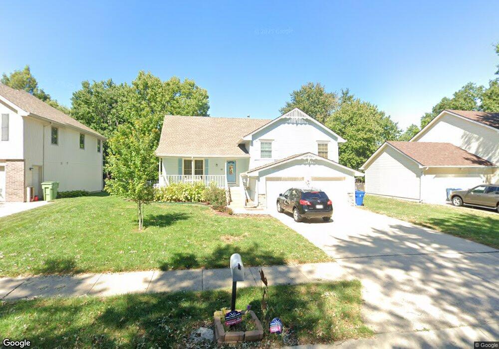
1628 Tudor Ln Liberty, MO 64068
Estimated Value: $335,834 - $386,000
4
Beds
3
Baths
1,852
Sq Ft
$195/Sq Ft
Est. Value
About This Home
This home is located at 1628 Tudor Ln, Liberty, MO 64068 and is currently estimated at $360,709, approximately $194 per square foot. 1628 Tudor Ln is a home located in Clay County with nearby schools including Alexander Doniphan Elementary School, Liberty Middle School, and Liberty High School.
Ownership History
Date
Name
Owned For
Owner Type
Purchase Details
Closed on
Apr 10, 2015
Sold by
Chase Noel G and Chase Peggy A
Bought by
Noel G Chase & Peggy Revocable Living Tr and Chase Peggy A
Current Estimated Value
Purchase Details
Closed on
Feb 14, 2001
Sold by
Schmit Joseph M and Schmit Lisa A
Bought by
Chase Noel G and Chase Peggy A
Home Financials for this Owner
Home Financials are based on the most recent Mortgage that was taken out on this home.
Original Mortgage
$127,960
Outstanding Balance
$46,083
Interest Rate
7.04%
Estimated Equity
$314,626
Create a Home Valuation Report for This Property
The Home Valuation Report is an in-depth analysis detailing your home's value as well as a comparison with similar homes in the area
Home Values in the Area
Average Home Value in this Area
Purchase History
| Date | Buyer | Sale Price | Title Company |
|---|---|---|---|
| Noel G Chase & Peggy Revocable Living Tr | -- | None Available | |
| Chase Noel G | -- | First American Title Ins Co |
Source: Public Records
Mortgage History
| Date | Status | Borrower | Loan Amount |
|---|---|---|---|
| Open | Chase Noel G | $127,960 |
Source: Public Records
Tax History
| Year | Tax Paid | Tax Assessment Tax Assessment Total Assessment is a certain percentage of the fair market value that is determined by local assessors to be the total taxable value of land and additions on the property. | Land | Improvement |
|---|---|---|---|---|
| 2025 | $3,500 | $50,050 | -- | -- |
| 2024 | $3,500 | $45,510 | -- | -- |
| 2023 | $3,560 | $45,510 | $0 | $0 |
| 2022 | $3,025 | $38,190 | $0 | $0 |
| 2021 | $3,002 | $38,190 | $6,650 | $31,540 |
| 2020 | $2,726 | $32,570 | $0 | $0 |
| 2019 | $2,726 | $32,566 | $6,080 | $26,486 |
Source: Public Records
Map
Nearby Homes
- 1601 Dunwich Dr
- 405 Wherritt Ln
- 1561 Parkside Dr
- 509 Belmont St
- 1232 Old Manor Rd
- 429 Pershing St
- 53 Fulkerson Cir
- 1768 Homestead Dr
- 1209 Liberty Drive Terrace
- 607 Glendale Rd
- 407 Glendale Rd
- 1856 Arbor Trail
- 1836 Green Meadow Dr
- 1515 Trumpet Ct
- 1010 Wellington Way
- 1829 Green Meadow Dr
- 1114 W Liberty Dr
- 1849 Arbor Trail
- 1845 Arbor Trail
- 1985 Longview Dr
Your Personal Tour Guide
Ask me questions while you tour the home.